Dreaming Of A White Christmas? Here Are The Odds
BOSTON (CBS) -- Are you "dreaming of a white Christmas"? I would think that most folks like the idea of waking up Christmas morning to a white blanket of mood-setting snow. But, would you believe, I conducted a Twitter poll and 40% said they would prefer a green/brown Christmas?! Really? Have you no Christmas spirit? Does snow mean nothing to you other than shoveling and snow blowing? Well, if you are one of those Christmas snow-haters, you'll be happy to know that our chances (in the Boston area) have been dwindling with time.
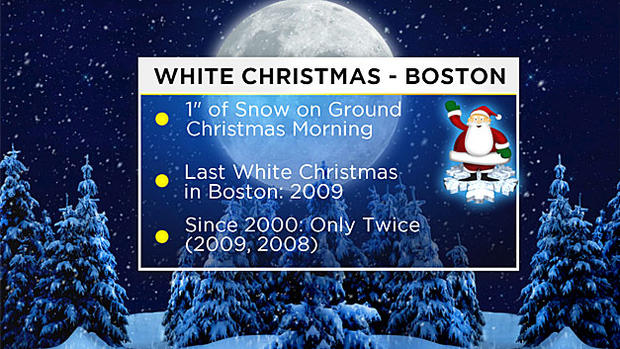
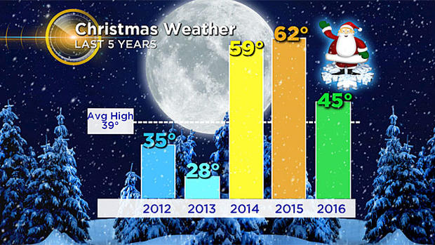
Since we began keeping records (in the late 1800s) Boston has averaged a fairly steady 20%, or 1 out of 5 years with a White Christmas. However, if you look at more recent years, since 2000, Boston has had only 2 years with a White Christmas, 2008 and 2009 (down to 13%).
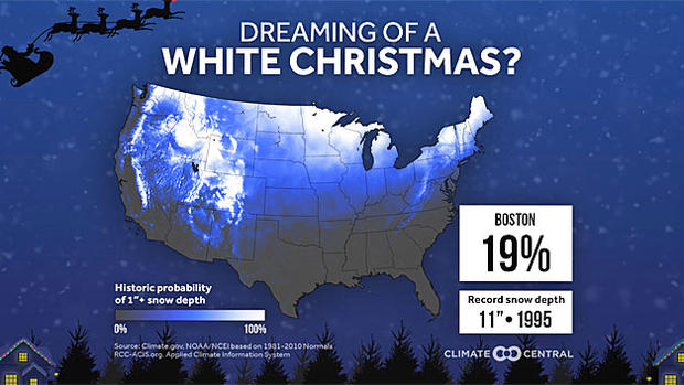
What exactly do we mean by "White Christmas"? The National Weather Service defines it as 1" or more snow on the ground Christmas morning. So, it could actually snow on Christmas Day (like it did back in 2002, 3.3"), but if there wasn't an inch or more on the ground when the daily snow depth report was taken, it doesn't count.
Still, it is sort of surprising, isn't it? Only twice in the last 16 years? And zero times since 2009? We are due!
So is this the year we get back on the White Christmas train? It sure started out promising…this is clearly one of the coldest Decembers in recent memory. With about 10 days left in the month, Boston is averaging nearly 2 degrees below the average. Combine the cold with the 6.1" of snow which fell in Boston back on the 9th-10th (the most snow to fall in any December storm since 2013) and it seemed we were almost a lock for a snow-covered ride for Santa right into Boston.
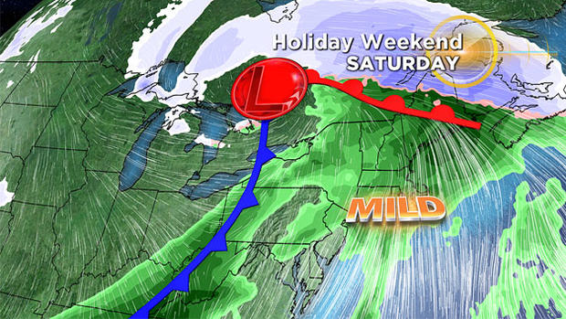
BUT…We've now gone a week without any snow reinforcements, and in fact, we have even had a few light rain events. Snow cover (especially in the City) has been disappearing day by day and the forecast this week is far from ideal. We jump well into the 40's on Tuesday, stay dry through Friday and then comes the nail in the coffin…Saturday. Just two days before Christmas, a storm system will pull up way west of New England (into the Ohio Valley) and a surge of warm, moist air will ride up into New England.
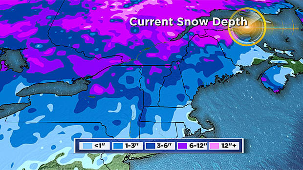
High temperatures on Saturday could reach near 60 degrees in parts of the area. Strong southwest winds along with periods of rain will likely eat away most, if not all the remaining snow anywhere near the City. The rain will extend all the way into central and parts of northern New England as well. Granted these areas have a lot more snow on the ground than Boston, but still, this will be a significant blow to the existing snow-pack in the entire region.
One last chance…There is one last possibility and that comes on Christmas Day. A second storm will likely form on the frontal boundary left from the Saturday storm. Conditions later Sunday and Monday will be cooler but the question right now is how much cooler. With this storm a week away, there is still a range of possibilities. At this writing I would say it is about 50-50 for chances of accumulating snowfall on Christmas Day...there is still room for a near miss out to sea or a track farther west and a change to rain. As always...stay tuned!
Follow Terry on Twitter @TerryWBZ