Beyond The Forecast: Hurricane Jose Draws Closer
BOSTON (CBS) -- Hurricane Jose had a window to intensify on Sunday, and it managed to do so as winds increased to 90mph. But that window will close as we head into Monday and beyond.
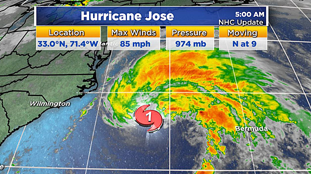
It is encountering some wind shear which is a deterrent to strengthening but that shear is slated to decrease as the storm travels over colder ocean water. So the chance of any significant hurricane striking New England is close to zero. Expectations are that the system will weaken to a tropical storm late Tuesday as it moves into rapidly cooling waters (in the 60s) and loses its heat engine source north of the Gulf Stream.
The latest projected track by the NHC steers the storm close to New England with some sharp turning on the approach. The precise path Of Jose is highly dependent upon when the curvature commences. It is entirely possible that Jose will move a bit faster and be close to the Buzzards Bay/Cape Cod area before it starts a more abrupt turn triggered by an approaching trough, or on the other hand a few more miles farther offshore. That last minute halt and turn will end up dictating the overall wind and rain impact for New England.
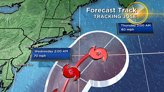
There is a slight risk that the approaching trough will not dig down enough to capture the storm which may produce a slowing and looping of the storm. Right now, my latest thinking is that would probably take place farther offshore.
So what does all this mean?
Some new guidance is suggesting a scenario meaning a blow from a strong tropical storm with the center passing near or just south of Cape Cod.
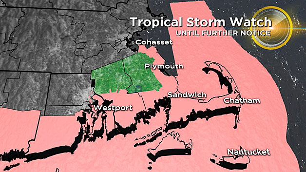
The National Hurricane Center has issued a Tropical Storm Watch for coastal Plymouth & Bristol counties, Cape Cod, Martha's Vineyard, Nantucket, coastal Rhode Island and Connecticut until further notice. This means that tropical storm force winds, heavy rain, moderate threat to life and property, and significant damage or power outages are possible within 48 hours. When/if it becomes certain that these impacts will occur, the watches will be upgraded to warnings.
However, it will look and feel much like an extra strong nor'easter around here, certainly nothing to take lightly. A few reasons for concern if the strong nor'easter scenario were to play out.
WIND:
Northeasterly gusts of 45-65 mph are expected over southeastern MA & Cape Cod And other parts of the South Coast in a tightening pressure gradient as high pressure builds across southern Canada.
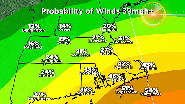
A few gusts to 70 are possible over the islands, particularly Nantucket. Less wind will occur farther northwest of Boston but gusts of 25-40 mph seems plausible in those areas.
COASTAL FLOODING/EROSION:
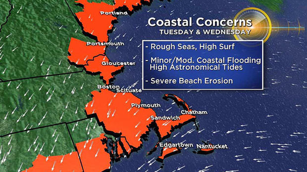
Perhaps the most significant threat from Jose is along the coastline. Due to astronomical conditions (namely the new moon), the scheduled height of the tides is around 11 feet. The northeasterly gales will increase that height for 3 or 4 high tide cycles occurring around noon and midnight on Tuesday and Wednesday.
The onshore winds will begin late Monday then ramp up in strength Tuesday, peaking on Wednesday. At least moderate and perhaps pockets of major coastal flooding cannot be ruled out along with significant beach erosion. Seas would be rough all week long, peaking late Tuesday and Wednesday with 10-25 ft swells just offshore.
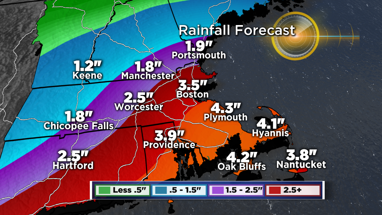
RAIN:
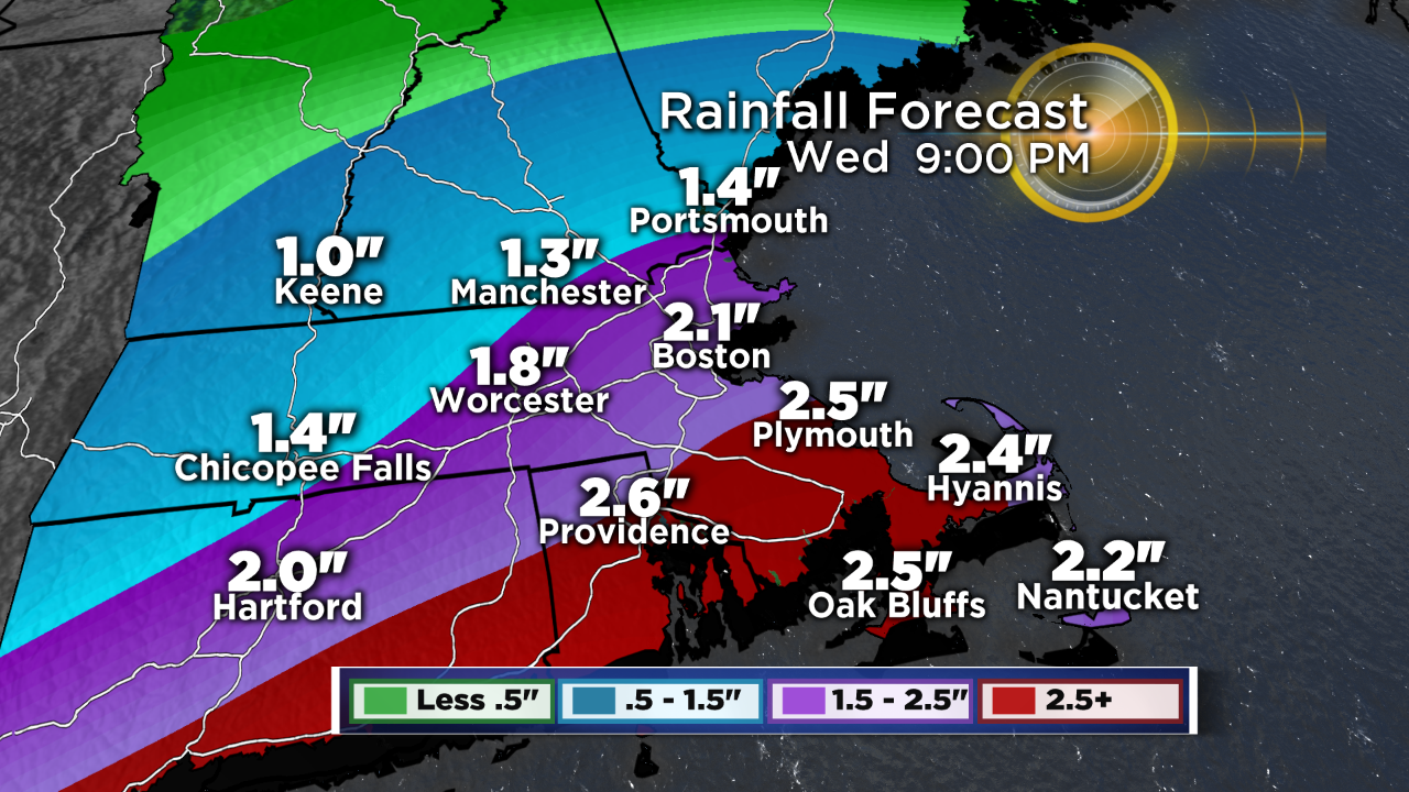
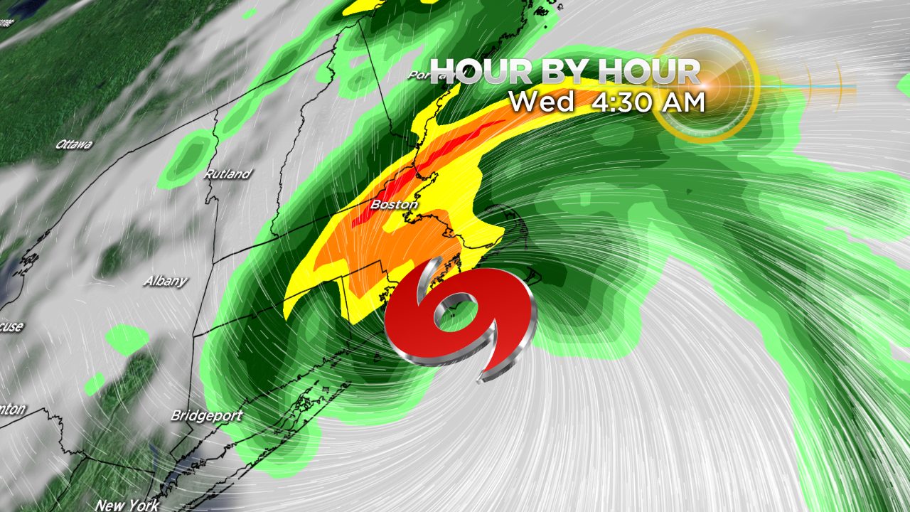
Some early, outer rain bands likely would arrive on Tuesday, spiraling in from Jose well to the south. Bands of tropical downpours would rotate off the ocean Tuesday night and Wednesday, likely leading some localized flooding.
Rain amounts over southeast MA could reach 2-3" just north & west of Boston up to to 3-5" over southeastern MA. Where the heaviest tropical bands set up, some isolated 5"+ totals will be possible.
TREE DAMAGE & POWER OUTAGES:
With all the leaves still on the trees, this raises the possibility of tree damage and power outages. There is always more risk when the trees are fully foliated.
With all this said, there remains an element of uncertainty pertaining to the precise track and the turning of Jose. Consequently, pay close attention to forecast updates in the next 24-48 hours for further clarification.
Coastal residents and boat owners should be thinking about and carrying out any necessary preparation. Stay tuned to WBZ-TV and CBSBoston.com for frequent updates over the weekend.
Follow Barry on Twitter @BarryWBZ.


