Early Spring Nor'easter On The Way To New England
BOSTON (CBS) - An early spring nor'easter is on the way to New England this weekend, 20 years to the date on the anniversary of the infamous April Fools' Day Blizzard. First and foremost, let me assure you that we are not forecasting a repeat performance from 20 years ago, when 25.4 inches of snow fell in Boston and 33 inches fell in Worcester. However, we are forecasting some snow accumulation for a large portion of our area as the calendar flips to April.
This is one of those storms when temperatures will hover right around the critical freezing mark for nearly the entire event. And it won't just be near 32 at the ground but temperatures will also be marginal aloft, several thousand feet up. So to sum it up, borderline temperatures!
Late March/early April snowstorms are never easy. The atmosphere is going through some complex transitions and changes. In order to get a big snow accumulation this time of year, things really have to line up perfectly (a la 1997) and that does NOT appear likely this go around.
So what is likely to happen? Let's break it down.
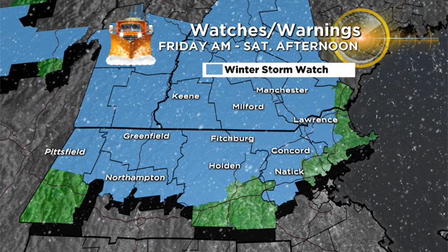
Friday Daytime:
Snow will likely begin to fall as early as dawn in westernmost New England. Throughout the morning, areas of light snow will be present mainly in central and western Massachusetts. It will likely take until afternoon before the snow spreads east and encompasses our entire region. Having said that, most of the snow that falls during the daylight hours of Friday will be low impact, more of a nuisance-type precipitation. I wouldn't expect much snow to stick or accumulate on roads before dark. Snow will likely mix at times with sleet and rain near the coast and areas south of the Massachusetts Turnpike.
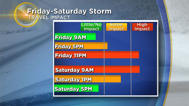
Friday Night:
This is when things start to get interesting.
The intensity of the precipitation will increase and at the same time, a surge of "milder" air will push in aloft from the southwest. Where the cold air hangs on, several inches of heavy, wet snow will accumulate. Most likely areas for this to occur (and best chance of plowable snowfall) would be towns north of the Mass Pike and with some elevation.
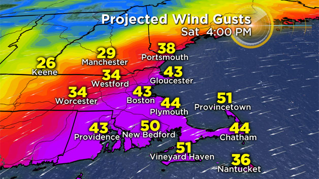
Included in the "most likely to see plowable zone" would be the Worcester Hills, the Berkshires and the Monadnock Region. Areas right at the coastline and south of the Mass Pike will gradually see a change to sleet and rain overnight. Winds will also steadily increase Friday night, especially along the coast and over Cape Cod where gusts to 50 mph are possible.
Saturday:
The wintry mess continues through Saturday morning, with rain to the south and near the coast, a mix just northwest of Boston and more snow in elevated areas and in central and northern New England. Winds continue to gust 25-50 mph (strongest at the coast) throughout Saturday, eventually turning from northeast to north-northwest as the storm passes by. The precipitation will likely end as mostly snow, tapering off from west to east in the afternoon, shutting off completely by evening.
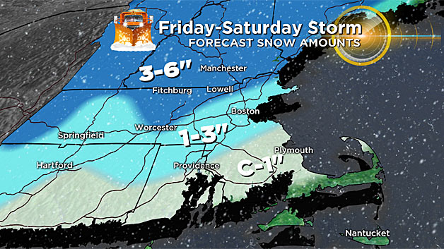
How Much:
A coating to an inch along the South Shore and South Coast, turning to slush then washed away by rain.
One-to-3 inches in and around Boston, including the North Shore (eastern Essex County), areas away from the Coast in northern Plymouth and Bristol counties and parts of Middlesex County as well.
Three-to-6 inches Route 495 points north and west including northwest Middlesex County, parts of the Merrimack Valley, northern Worcester County and a good portion of Central and Northern New England. Ski season lives on!
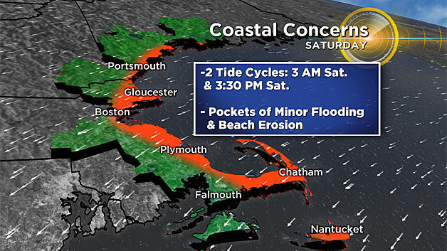
One final note - we will be watching the coastline for the possibility of minor coastal flooding during two high tide cycles - both on Saturday.
The onshore wind will build our seas 5-to-10 feet just off our coastline. Some pockets of splash over, minor beach erosion and flooding of vulnerable shore roads will result a few hours either side of the pre-dawn and afternoon high tide cycles.
Please, as always, stay tuned to updated forecasts on WBZ-TV, WBZ NewsRadio 1030 and CBSBoston.com.


