Weather Alert: Complex Nor'easter On The Way
BOSTON (CBS) - Snow, sleet, freezing rain, rain, thunder, damaging wind, flooding…you name it, we got it. A multi-faceted, complex nor'easter on the way for tonight and Tuesday morning.
Peak impact from storm will be from 8pm – 8am tonight. Heaviest precipitation and strongest wind will taper off by mid- late Tuesday morning.
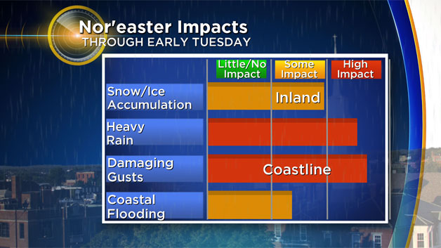
This one is truly all about location, location, location. Different impacts in each region of Southern New England.
The Snow/Ice Zone
Where: areas north and west of Boston
Ice is going to be a major component of this storm, with large amounts of sleet and freezing rain expected to fall. Temperatures from ground level through several layers of the atmosphere above are extremely borderline (within a degree or two of freezing) for most areas north and west of Boston. So, this will lead to a variety of precipitation types from snow to sleet to freezing rain…in short, a wintry mess. Areas from 128 to 495 will see just a coating to an inch or two of snow and sleet before eventually changing to mainly rain early on Tuesday.
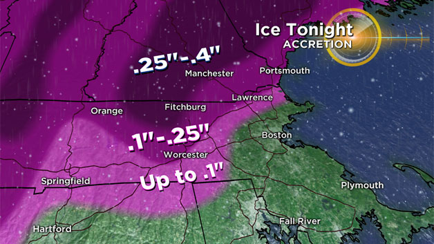
It gets more interesting north of the Mass Pike and around 495 and areas north and west. Here 2-4" of winter slop is likely…a crusty concoction of snow, sleet and some freezing rain to top it all off. The icy rain may also accrete up to .1"-.25" on some surfaces, making walking and driving quite treacherous. The snow/ice jackpot will be in northern Worcester County, The Berkshires and parts of Vermont and New Hampshire (mostly with elevation). In these spots we are forecasting 4-6" of snow and sleet and perhaps up to .4" of ice accretion. This could become a very serious situation in these areas, with ice weighing down tree limbs and power lines combining with a gusty northeast wind, there will no doubt be some significant tree damage and power outages.
The Heavy, Flooding Rain Zone
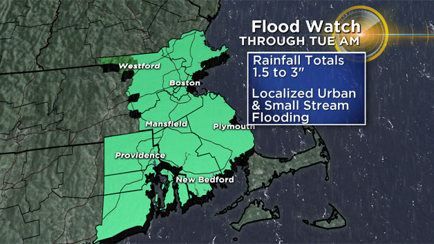
Where: Eastern MA
This system will be loaded with moisture, no doubt one of the juiciest storms in quite some time for drought-stricken Southern New England. A widespread 1-3" of rainfall is likely in all of Eastern Massachusetts, perhaps up to 4" locally. While this won't be a drought-buster (we have a long way to go), no doubt this will put a significant dent in our water shortage. The rain will come down in sheets overnight tonight and early on Tuesday. The large rivers can certainly handle the water, but many small streams could briefly overflow. There will certainly be loads of street and urban flooding, some very big puddles on the roadways for Tuesday morning's commute.
Strongest Winds
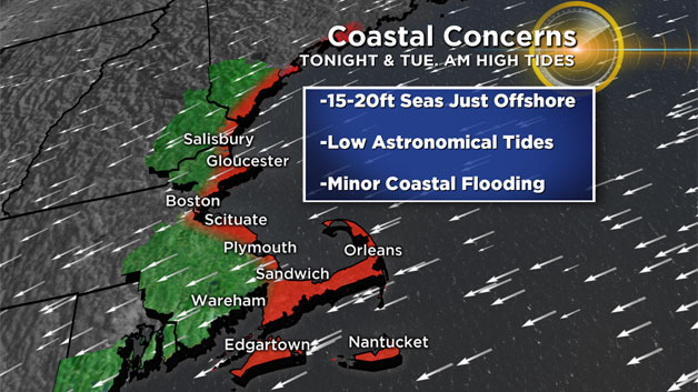
Where: Coastline, Particularly Cape Ann, South Shore, Cape Cod, Islands
This will be our most powerful wind event of the season this far. Wind gusts as high as 70mph are possible on the Outer Cape and frequent gusts to 60mph are likely on Cape Ann and all along the South Shore and Cape Cod. This will certainly lead to some tree damage and scattered outages. The peak winds will be just after midnight through early Tuesday morning, slowly decreasing during the day on Tuesday. Inland areas will also see gusty northeast winds 30-50mph at times overnight.

Coastal Flooding
Where: Spotty, Susceptible Coastal Locations
The great news with this storm: low astronomical tides. If this storm were coming during a higher tide cycle this would have been a much more severe coastal event. First timeframe to watch would be between 6p-10p Tonight…forecast is for minor coastal flooding as the storm will just be ramping up. Slightly more concerned about the Tuesday morning tide around 8am as the tides are a bit higher astronomically and the winds will have pounded the shoreline all night, leading to a bigger storm surge (3-4ft in spots). Again, mainly minor coastal flooding Tuesday morning with some splashover and washed out vulnerable roads. Seas will be very rough, building to 15-20feet just offshore during Tuesday morning.
This storm will no doubt have some surprises and curve balls. A system so loaded with moisture moving into a region with temperatures so close to the freezing mark means we need to be ready for anything over the next 12-18 hours. As always, stay tuned to WBZ-TV and CBSBoston.com for frequent updates.