A Look Back At New England's Year In Weather
BOSTON (CBS) -- The last day of 2016 brings us a light wintry mix over Boston, and some snow inland (coating to 2"). No major storms are in the forecast as we enter into the first week of 2017.
It's always interesting to look back at our year of weather. In my research, I realized we had a few more events than I remembered! Here are the biggest weather events for southern New England in 2016:
January 23-24 Blizzard
We had a very quiet 2015-2016 winter with below normal snowfall. But a couple blizzards impacted southern New England. The first was on Jan. 23-24 along south coastal Massachusetts onto Cape Cod. The system produced 6-12" of snowfall as 65-75 mph winds.
February 5th Snow Storm
A water-loaded snow storm brought 6-12" of pasty snow accumulation across most of southern New England. The strong winds created more damage and lots of people lost power.
February 8th Blizzard
This storm also gave the south coast & Cape Cod 6-12" of snow. Along with 65-75 mph winds.
April 3rd Snow
A late season snow storm gave areas away from the coast 3-6" of new snow. Strong winds lead to more damage reports, though.
April 4th Snow
The last snowfall of the season brought 4-8" inland across southeastern Massachusetts.
Quiet spring!
July 18th 22nd and 23rd brought severe storms through the area. There were numerous reports of wind damage and large hail.
The Drought
By the end of July, much of southern New England was under severe drought. As the weeks wore on, our rainfall deficit grew, and we were under extreme drought to wrap the summer season. Extreme drought conditions are still found over Massachusetts.
More on the drought here.
August 13th – 15thbrought a few rounds of severe storms.
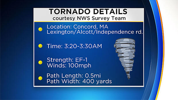
August 22nd Tornado
A t-storm moved through eastern Worcester County, then through central Middlesex County. Isolated wind damage was reported in Marlborough and Sudbury, then it produced a tornado. Concord was hit by the tornado, classified as an EF-1 by the National Weather Service. This was the first tornado warning since August 4th of 2015. First Massachusetts tornado since June 23, 2015 (Westminster/Wrentham). And, the first "nocturnal" tornado since July 11, 1970 (2:15am in Townsend).
More info on the damage here.
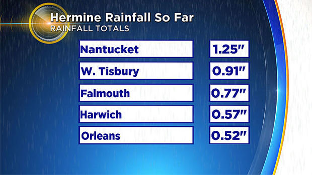
Post Tropical Cyclone Hermine
Labor Day weekend was threatened with Post Tropical Cyclone Hermine tracking up the coast. It produced nor'easter-like conditions with wind gusts up to 60 mph on the Cape. Isolated areas of damage and outages were reported. Sept. 11 brought severe t-storms that produced wind damage and hail across interior Mass. Some of us hoped for drought-busting rainfall across New England…instead the storm brought 1.25" of rain to Nantucket.
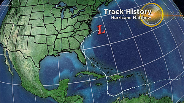
Hurricane Matthew
The WBZ Weather team kept a close eye on the progression of Hurricane Matthew in October. We had some beneficial rain as a cold front transported moisture from the storm. Damaging wind gusts up to 65 mph caused isolated tree and wire damage on Oct. 9 across southeastern coastal New England.
October 21st Flash Flood
Strong thunderstorms trained over the same area as a cold front moved through central, northeastern MA, northeastern CT and northern RI. Worcester had flash flooding in urban areas from 4 to 5.2" of rain in just 90 minutes according to SKYWARN spotters. Shrewsbury, Leominster, Fitchburg and Lunenburg also reported flooding. Behind the rain and storms, strong winds caused tree and wire damage as well as outages in isolated spots.
October 27th Snow
The first snow storm of the 2016-2017 season gave western Mass and hill towns 3-6" of wet snow. This weighed down power lines and trees and left thousands without power as the storm moved through.
December 17th brought some plowable snow to Boston and all over Mass., then the rain washed almost all of it away.
December 29th
Heavy snow fell across central and western MA. Ski resorts were in the jackpot zones of 1-2 feet of fresh snowfall!
A list of snow totals here.
2017:
The drought will continue to be a long-term focus. The rest of the winter will be slightly above normal for snowfall (Boston average about 44"), but back to a more typical winter.
In case you missed it, here is our winter weather prediction.
The WBZ Weather Team will be ready to keep you informed on whatever Mother Nature throws at us next year (and beyond).
Have a Happy New Year!