Coastal Storm To Bring Heavy Inland Snow and Wind
December is winding down, and most of it has run its course in typical style this year. Temperatures over the span of the month will end close to average. Snowfall will end close to average (in fact, even above average in spots). We've had some mild breaks and some solid cold snaps. Feels kind of nice after last year's unbelievable torch, which produced the warmest December on record in Boston. Now as we head into the final days, there's a good chance some will add to their snow tallies before closing the monthly ledger.
The setup calls for a rapidly deepening coastal storm during the day Thursday, and especially Thursday night. We could end up with 'bombogenesis', the rapid deepening of an area of low pressure by more than 24 millibars in 24 hours. The issue for snow lovers is that this low will take a track over SE Mass and hug close to the coast, flooding the lower levels with milder air. That makes it difficult for significant snowfall anywhere near the ocean. 'The coast is toast' as the saying goes for most of this system.
Inland, it's a different story! Borderline temperatures will cool as the storm gains strength, and keep many in the snowflake zone instead of rain. The intersection of this colder region safe from milder ocean air and the band of best lift on the edge of the storm will be where the most impressive snow totals occur. Where will that line be? That's the trick! Here I'll try to break down some of the details of the storm.
Timing - Thursday PM
The morning drive looks fine on Thursday, but clouds will be thickening up. As we head toward noon the first rain/snow showers should be moving in, with the rate of rain/snow increasing during the afternoon and evening. The peak of the storm should be Thursday late afternoon into the first half of the night as the storm wraps up and takes on that classic comma-head shape. A coastal front should form farther inland than usual - near I-495, separating the mild ocean air from the cold interior (with plenty of snowfall on the cold side). Our heaviest rain and snow will fall during this window.
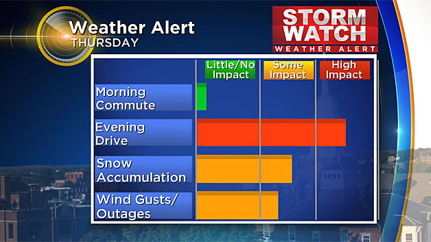
When it comes to question marks, the biggest one is how deep the low gets and in turn, how far east it can drag the snow line before it moves on. Anyone in the 128 corridor , Rhode Island, eastern CT, or SE Mass won't see much or any snow. The trend has been a bit farther west with the track, which means it's a rain storm for these spots. It now looks unlikely that a flip to snow to end will materialize, which was the only hope for snowfall in the 128 corridor or Metro Boston. We may still see the snow line come east during the evening out of the Worcester Hills, but not making much progress east of 495 as the storm heads north.
The coastal low heads into the Gulf of Maine and pounds much of interior Maine and New Hampshire Thursday night and Friday morning. All the rain/snow will be long gone around here by Friday morning, so crews should have ample time to work on the roads before the Friday morning drive.
Snow Totals
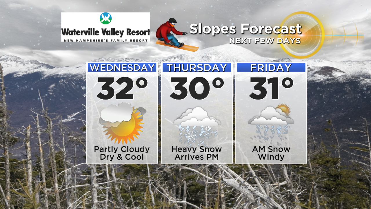
The bullseye for snow looks to be northern Worcester County to southern New Hampshire and northwards across most of New Hampshire and Maine. For these spots, a widespread 6-12" of snow looks reasonable with some locally higher totals for the more mountainous terrain - particularly up toward the Waterville and Mt. Washington Valley slopes where they could stack up 1-2 feet. What a gift for those at ski areas for the holidays! I have to say the timing is pretty great for anyone who enjoys the cold season. A hefty blanket of fresh snow for skiing, snowboarding, snowmobiling, snowshoeing, etc. And during vacation week/NYE holiday weekend. Pretty prime for winter enjoyment.
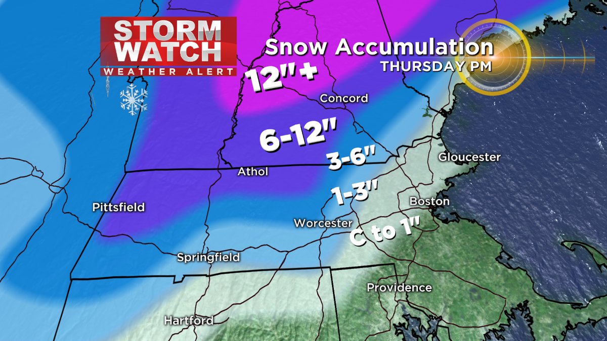
There should be an extremely sharp cutoff heading east toward the coast. The flip to snow may produce plowable snow into northern Middlesex County, and perhaps even into the Merrimack Valley if that band can drive eastward. Once you get to the North Shore, Boston area, or points farther south it's mostly just rain with no plowable snow expected.
As for snow-type, it should be on the wet side of a typical 10:1 ratio. Meaning, 1" of liquid could get you 10" of snow during a typical storm, and this one may end up more like 8:1 for most. Your 'bucket of slop' snow will be the stuff that falls near the coast at the end of the event. The more powdery snow will be found across interior Vermont, New Hampshire and Maine.
Strong Wind Gusts
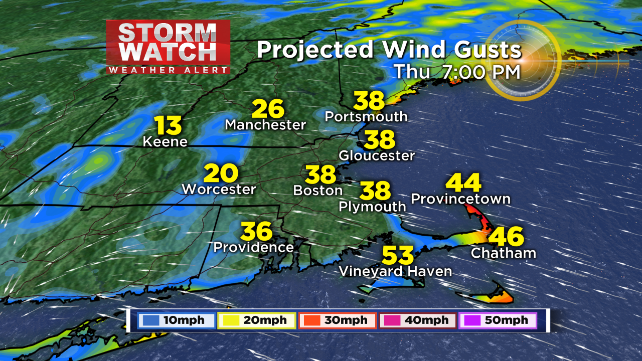
Since the storm will be strengthening rapidly, there will also be some gusty winds to contend with. Initially, these winds are southeasterly during Thursday afternoon (also the reason why we'll be raining to start in eastern Massachusetts). Gusts 30-50mph look likely there. Then I'd expect a lull Thursday evening as the low itself crosses right over us. But as soon as it starts to head north late evening and into the night, those winds will ramp up out of the northwest.
Initial winds during Thursday evening out of the E/SE
Those backside winds could gust 35-55mph, with isolated 60mph on Cape Ann Thursday night into early Friday morning. Some scattered power outages, especially where pasty snow sticks to wires and trees, are possible. Winds will stay gusty all Friday long as the storm spins off the coast of Maine, keeping a chilly feel in the air as we dry out.
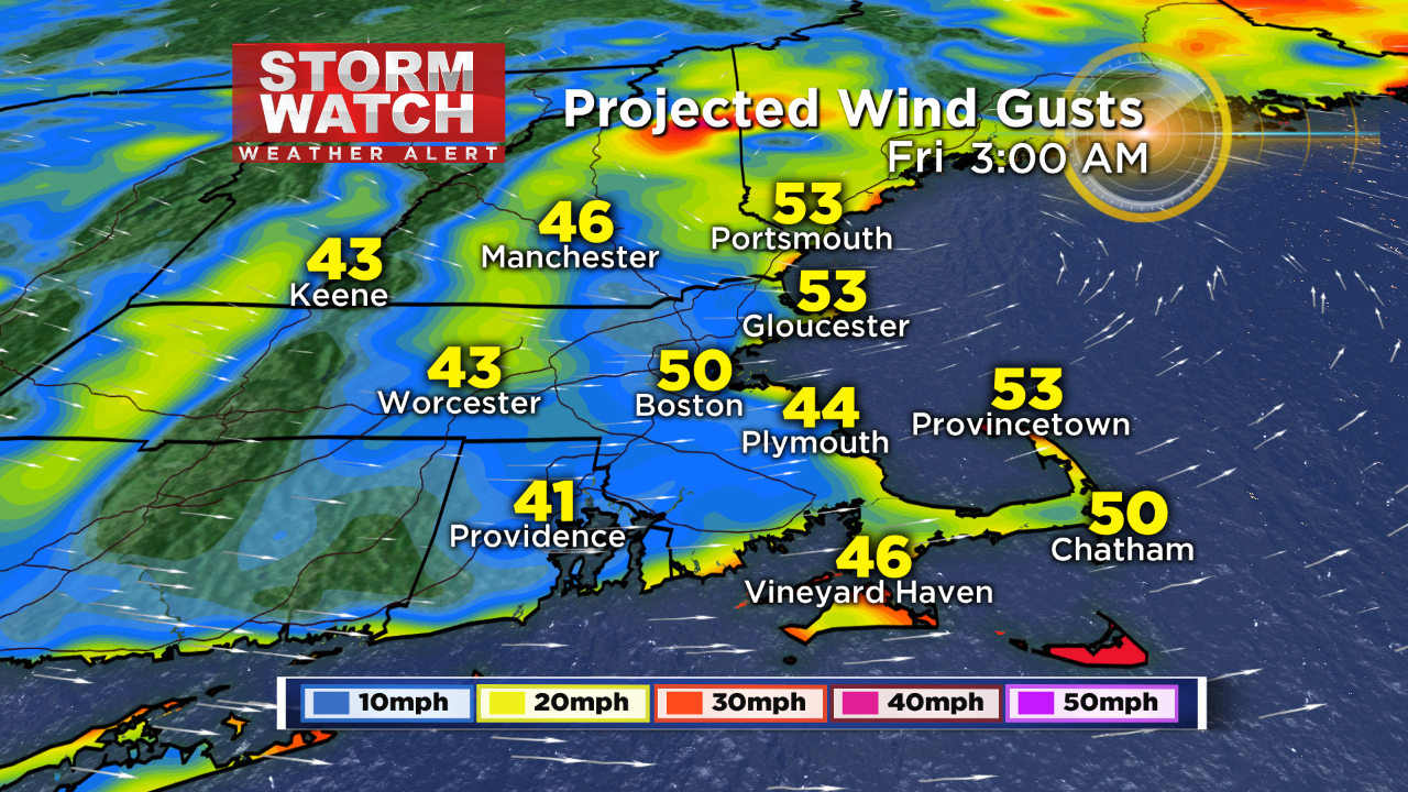
Backside W/NW winds strong across the region Thursday night into Friday morning. Gusts to or even over 60mph will be possible along the coast, especially Cape Ann.


