November Musings - When Will The Cold Arrive?
Find Eric Fisher on Twitter and Facebook
The leaves are starting to fall and time will indeed fall (back) this weekend. Baseball is over, the Patriots are in mid-season form, and plow operators are lining up accounts. Before you know it, Mariah Carey will be blaring on the radio. The season of change is upon us, but will we get another dose of late season warmth a la the past couple years, or will winter start knocking early? Here are a few thoughts on the weeks to come as get ready to carve up the bird and deck the halls.
For starters, our weather is really, completely, totally, boring for the next 7 days. As in, I actually told producers they can take time away from my weathercasts boring (a rarity, no question!). Pretty much nothing happening and seasonable temperatures are the general rule through at least Thursday of next week. We have a couple of weak disturbances coming through over the course of Saturday and Sunday. The first brings some scattered clouds and maybe a sprinkle over the high terrain. Sunday's brings a couple flurries/rain showers and a reinforcing shot of chilly air. But the majority of towns will not receive a drop of rain over the next 7 days. Zzzzzzzzzzzzzzzzzzzzzz
Rinse and repeat - this trough south of Alaska keeps on regenerating thanks to a strong Pacific jet stream, pumping up a warmer pattern for much of North America. Source: Weatherbell
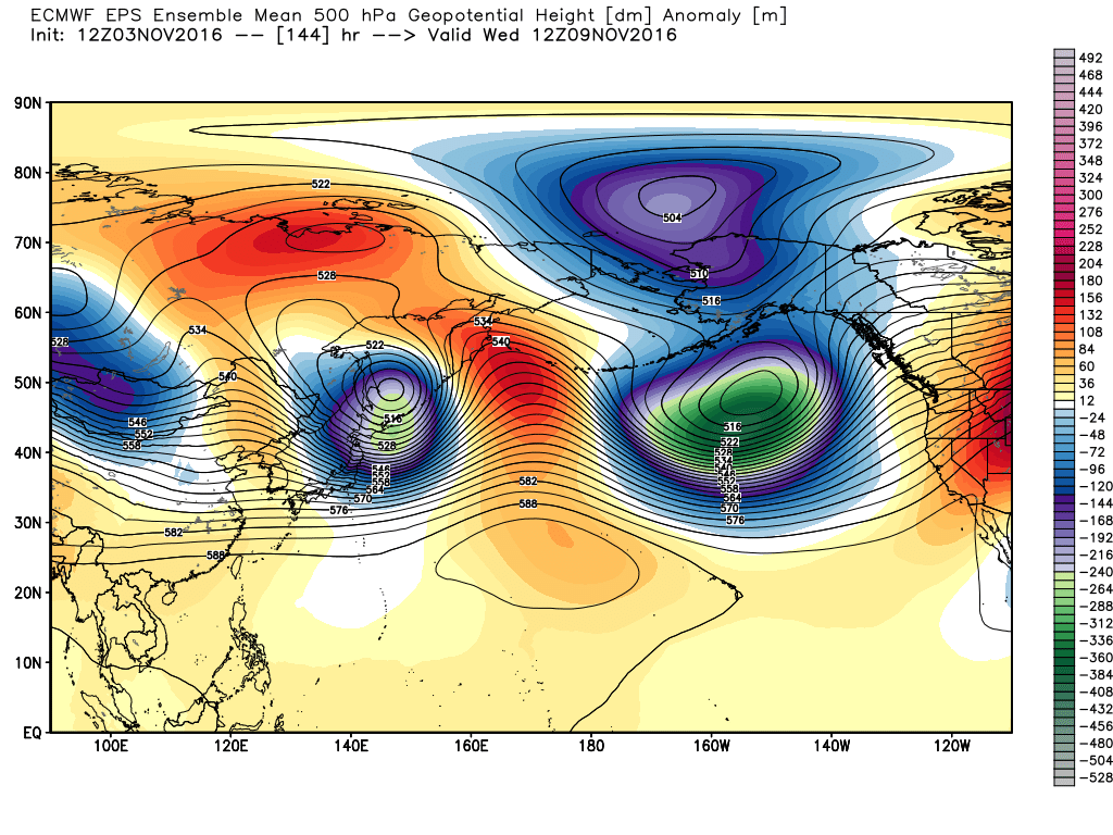
What happens at the end of that boring week? Well there are some interesting happenings in the jet stream, which can be traced back to the Pacific. A 'standing wave' of low pressure sitting over the northeast Pacific will continue to pump up a ridge over the western half of North America. Basically, jet energy continues to keep this deep trough in place over the ocean, and that storminess helps thrust mild Pacific air poleward and eastward into Canada and the U.S. The ridge that results is going to be a monster, reminiscent of what we saw in December of 2015, just farther west.
Departures from average this warm remind me of December 2015, though they were across the eastern U.S. at that time. Source: Weatherbell
Steep as this ridge is, 60s and 70s should be able to make their way into Canada next week. This will eradicate just about all snow cover from the Lower 48 and southern/central Canada by Thursday, outside of high mountain peaks (even that will be sparse except the Canadian Rockies). That will be important down the road, because it makes for a warmer 'source region' for cold air outbreaks down the road. Record highs should jolt their way into the northern Plains, Upper Midwest, and Canada during this time.
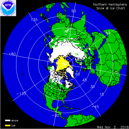
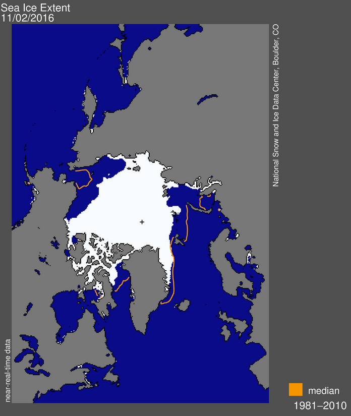
Current northern hemisphere snow cover from the NOHRSC and current sea ice extent from the National Snow and Ice Data Center
Speaking of 'source areas' - the roof is on fire, so to speak. While it's never really 'warm' around the north pole in cold season, temperatures have been at record levels above average. This has stalled any sea ice growth in recent days, a trend that continues into next week. We're at record low levels of sea ice by a wide margin to start November with little sign of any improvement in the next 7-10 days. The latest report pegged ice coverage as nearly 1 MILLION square miles less than the long-term average. Less ice = lower albedo (sunlight being reflected back into space) and more energy being absorbed by the water. It's meager, since there are only a few hours of sunlight around the arctic circle this year. But it can play a small role. More importantly, less ice overall makes for less ideal conditions to 'cook' frigid air for lower latitude invasions.
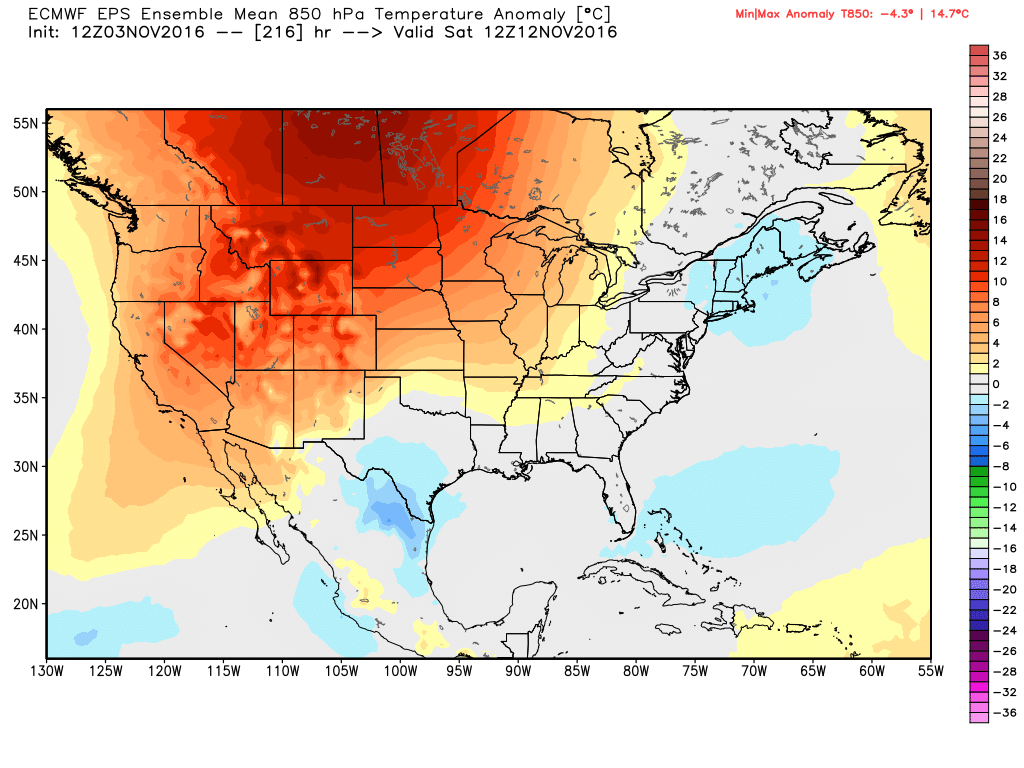
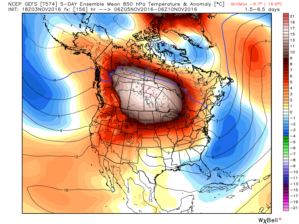
A pocket of chilly air looks likely toward next weekend (the 12th and 13th) but right now it doesn't appear to be particularly potent. The overwhelming signal across the Lower 48 is for warmth, especially west. Source: Weatherbell
For a long time, indications have been for a trough to start carving out room downstream of this ridge into the eastern U.S., starting next weekend. While it still looks like this will take place, it may not necessarily mean much truly cold air. Currently all the really brutal arctic cold is locked up across Russia, which has had a miserably cold and snowy run of it over the past 30 days or so. That harsh cold, which typically might be found around the pole this time of year, now has a more difficult road to reach us. You need cross-polar flow bringing it from Siberia all the way across the pole, across Canada, and then into the eastern U.S. The setup starting next weekend doesn't really look to make that happen. The source of our air will be from the north, but will also be exceptionally warmer than average for that region. The result is cooler weather, but nothing spectacular. We also have very little blocking over the North Atlantic (in other words, none of the 'coveted' -NAO) to keep cold air in place over the east. Without that, any blows of cold air would be fleeting this month.
When it comes down to it, there's no way the Lower 48 will end up with anything but a MUCH above average month of November in terms of temperature. There will be gigantic positive anomalies across the central and western U.S., and if that cold air can entrench itself in the east some mildly below or near-average temps for the month. We're on the cool side of things here in New England, and even have a small chance of notching our 2nd below average month of 2016. But I wouldn't expect the arctic cold to visit us before Thanksgiving.
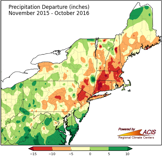
Rainfall deficits dating back over the past 12 months. Source: Northeast Regional Climate Center
How about the drought? There's still a very long way to go on that front. October was a good month for parts of the area, but we still have monster rainfall deficits going back over the past 12-18 months. You need months of stormy weather on end to make up for how much rain/snow we haven't seen in that time. And the first half of November is going to bring very meager rain totals, with some towns not even seeing a tenth of an inch. A digging trough would be a good sign for us, even without any major cold. It will help guide storminess our way to make up for the dry first half. But I'm not overly optimistic we'll be able to make up too much ground on the drought with such a slow start. Hopefully proven wrong with a couple of solid late month storms!


