Summer Drought Approaching Historic Levels
BOSTON (CBS) -- I was having a spirited debate with colleague David Epstein the other day about our current drought situation. I was making the case that this drought was nasty, but they never last for too long here in New England.
All it takes is one good tropical connection and we'll put a huge dent in this. Our lawns are brown, our gardens need a lot of watering, but it could be worse.
Now, many of you know David is an avid gardener, and so his opinions on the drought are a little stronger. He also pointed out the lack of work for landscapers who aren't mowing, or the golf courses that are drying out.
At the same time, beachside businesses are booming and it's been fantastic weather to enjoy outdoors. There are always two sides to the coin, although there's no doubt that the amount of water leaving our landscape under the hot summer sun every day is substantial, and we're going to pay the price in a few different ways.
So let's talk about it in a couple of different ways--where do we stand historically, and what's coming next?
For starters, how about that rain event Friday? Pretty weak. Most towns only picked up 0.1" to 0.3" of new rain. Nice to have, but certainly not going to help out our situation much. What robbed us of the best rain was convection (thunderstorms) off to our south. As the system was approaching, it was gathering tropical moisture from the south and drawing it poleward toward us.
But a large cluster of storms that developed off the Mid-Atlantic intercepted a lot of that moisture, acting as a bit of a wall. In the end, that also ends up leading to some sinking air motion on our side of the thunderstorm complex, which helps squash storms of our own. Long story short - it stinks. We really needed a widespread soaking and we were 50-75 miles away from getting it. The ocean got a solid watering over Long Island Sound and off Nantucket.
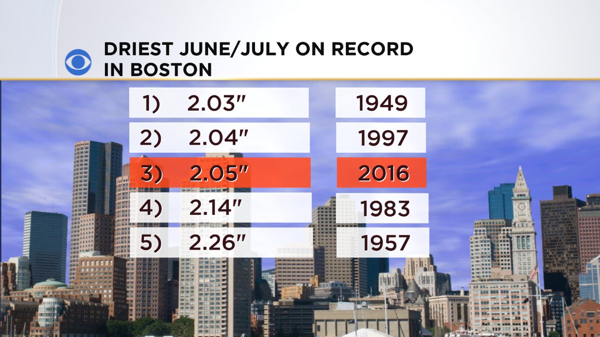
That being said, Boston now stands at just a touch over 2" of rain for the months of June and July combined. That makes it the 3rd driest June-July on record, unless we end up getting some rain on Sunday (possible). Each town/city is a little different because summer rain, by definition, is sporadic. Some towns get lucky and receive a few storms, others keep missing. For example, Worcester has seen ~3.5" of rain in the same time. Still dry, but not as bad. The driest area of all has been the space between the Pike and the New Hampshire border.
Some rain deficits are over 10" for the year now in this relatively small zone. We can easily see it - all the ballfields are burned out and trees are already starting to show stress. You can expect to see a lot of early leaf drop over the next several weeks as the least healthy of the trees start shedding ahead of schedule. It's typical to see leaves falling in August in any year, but it will very likely be much more widespread this time around.
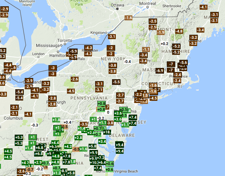
Departure from average rainfall June-July. Source: SERCC
There's quite a dichotomy between the haves and have nots over these past couple of months. The storm track has been extremely persistent - sending waves of storms and rain down into the Mid-Atlantic and bypassing New England. You can see from this SERCC map above that the largest departures from average over this time are right here at home, especially along and north of the Pike. It's a thin corridor but an important one if you're living in it!
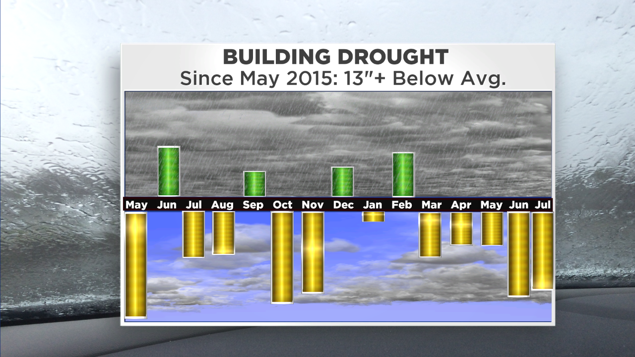
It's not just this year though. The drought started building last year, with a very dry July-November in particular. Winter brought average precipitation, but a lot of it fell as rain. That's not as helpful as snow, because it tends to just run off in winter. We're better off with a gradual release of snow melt in the spring to slowly keep the ground moist and steadily feed aquifers. Not much of that going on this past spring. The good news is that at least it wasn't hot in June to kick off summer.
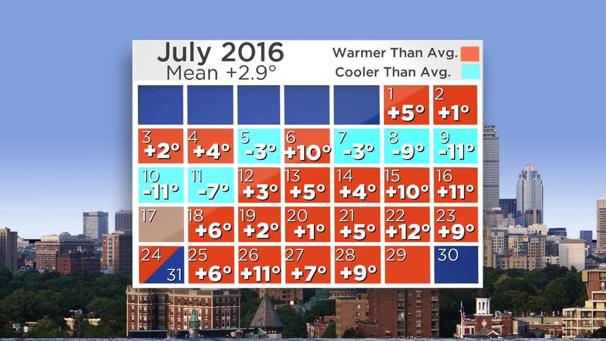
But July has featured a very toasty second half. As I write this, Boston is looking at its 8th warmest July on record, dating back to 1872. With a couple days left that may change a place or two in the standings, but a Top 10 finish looks likely. That's almost entirely due to the stretch that began on the 12th. We've had 18 straight days of above average temperatures in Boston, and 12 days of 90+ heat this month. That's way more than usual, but not enough to get a Top 5 standing for July 90s. For the year, we're sitting at 13 days of 90+ heat, which is the average number for an full year in Boston. We'll see how many we end up in August/September.
What's on tap? Well, a little rain, at least. This weekend it's another setup that's sure to frustrate those rain dancing in their backyards. An open wave of low pressure will approach from the west and jam up against high pressure settling over eastern New England. The result is that more stable, marine air will get pushed in from the east, and keep the higher instability away from (just) us here locally. Areas of storms and locally heavy showers look likely across New York, southern Vermont, and even western Massachusetts/Connecticut. But that easterly flow will probably keep any significant rain away from eastern Mass, Rhode Island, and eastern New Hampshire. Almost as if rain was going out of its way to miss our little corner of the globe.
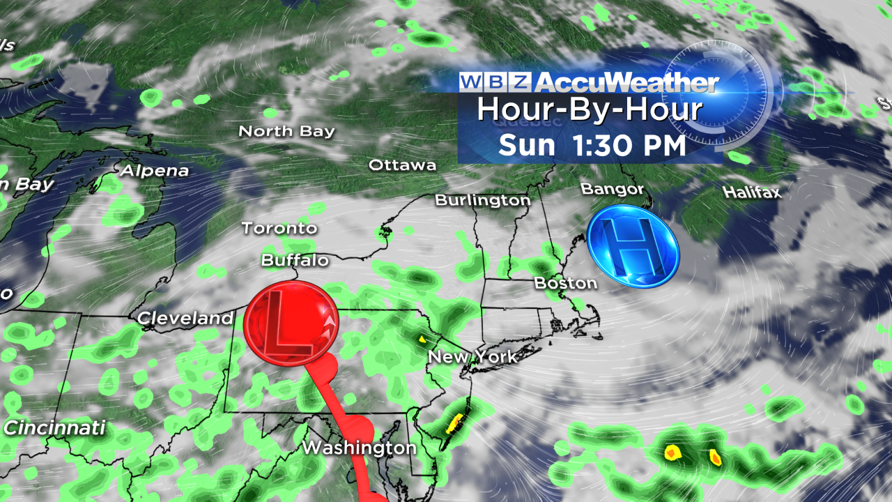
IF we can get some decent downpours going, the best shot looks like Worcester County up through southern and central New Hampshire. The timing for this would be Saturday night into the first half of Sunday. The setup doesn't change much on Monday - still high pressure holding the best rain chances at arm's length from us to the west and north. If we're lucky, we'll be able to squeeze out at least a few showers on Monday. At the very least it's going to be much cooler and less sunny, which will give plant life a break. Highs will stay in the 70s both Sunday and Monday, and possibly into Tuesday as well.
So what will it take to break the drought? Look to the tropics! We don't want to get creamed by a hurricane, but it would be real nice if one could get closer to the U.S. shoreline and get a plume of tropical moisture entrenched into the eastern seaboard. Tropical systems don't have any problem producing 4"+ rain totals (naturally, it would flood at this point because the ground is so hard). But the tropics will start heating up in August and we'll be open to the potential of at least tropical rain over the next few months. There are no great rain chances over the next 10 days, but hopefully down the road we'll break the trend and get a solid soaking. Until that happens, this drought will likely go deeper as the dog days roll on.