After A Very Mild Winter, Will Summer Sizzle?
BOSTON (CBS) - The automatic reaction of any true New Englander after a mild winter: "We're going to pay for this." Instinctively, we are always looking over our shoulders. There are few I've come across that simply believe the easy life is going to keep on rolling. And so we've been inundated with questions about how crappy this summer is going to be. There are two separate camps - the 'cold and wet' camp and the 'melt your face off' camp. But certainly, we can't pull off another comfortable and sunny summer like the last two, right? Especially after such a weak winter, right?
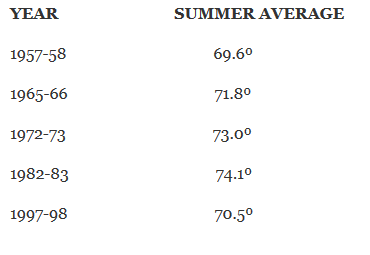
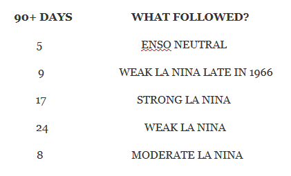
To either stoke fears or ease them, I started to dig into some data. A good starting point was to look at past strong or very strong El Nino years, and seeing how they evolved over time. There are only a handful of them on record, so the sample size is manageable. Below are the strong/very strong event years, the average summer temp (over all of June/July/August), the number of 90+ degree days we saw in each, and how El Nino weakened and La Nina picked up. By the way, the average temp for a Boston summer is 70.5º
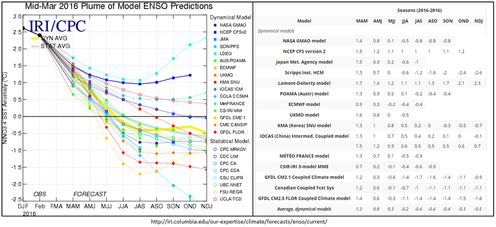
From here we ask, how will this El Nino exit? That's still a debatable question. After zeroing in on La Nina a couple months ago, the spread among guidance has grown. It's now all over the place, with solutions ranging from a strong La Nina by summer to El Nino holding on through the year. From observational data, it certainly seems that El Nino has been weakening. And more often than not, El Nino does transition to La Nina. I'd place a bet on at least ENSO neutral, if not a weak La Nina, taking shape by mid to late summer.
But here's a problem - there's no strong, obvious trend between how El Nino exits and our summers here in southern New England. The table above shows that we've had hot summers with a weak La Nina setting in, hot summers with a strong La Nina, and a typical summer with a moderate La Nina. Not exactly a screaming signal. However, 4 of the 5 strong to very strong events had at or above average summers here in the Boston area. Only 1957-58, which went ENSO neutral, turned in a below average summer in terms of temperature. So we can at least give some weight to the idea that the summer following El Nino increases the odds of above average temperatures in the summer. Intuitively this makes sense, since El Nino helps release tremendous amounts of heat into the atmosphere. There's more warmth in the overall global circulation to work with, and while that doesn't translate to every area having above average temperatures, it does increase the chances to get atypical warmth.
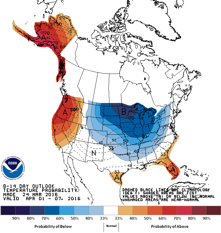
So that's a little look at the El Nino piece. But what if we just look at very warm winters. What typically happens when New England exits an unusually mild winter season? Below is a list of the Top 10 warmest winters, departure from average the following summer, and how many 90+ days we saw in each of those summers.
YEAR SUMMER DEPARTURE 90+ DAYS
2001-02 +1.8º 24
2015-16 ? ?
2011-12 +1.7º 12
1932-33 +0.1º 15
1990-91 +2.3º 24
1931-32 +0.6º 4
1912-13 +0.3º 9
1948-49 +3.6º 21
1936-37 +0.9º 13
1952-53 +1.4º 14
While there's quite a bit of variability in here year to year, especially when it comes to 90+ days, there is a clear pattern. All of these easy street winters were followed by warmer than average summers, including the 2nd warmest on record (while the warmest on record followed a strong El Nino winter, 1983). The top 4 warmest all had plenty of 90+ days. So now we can say that coming out of either a strong/very strong El Nino and/or a Top 10 warmest winter, all but one summer came in above average. Now we have a stronger signal to work with!
On top of all of this, I've been keeping an eye on the similarities between this El Nino event and the 1982-83 event. It's not perfect, since no two El Ninos are alike. But this one has much more closely tracked along 1982-83 than 1997-98. Unfortunately, we only have three very strong El Ninos on record to compare, which is less than desirable. But let's run with it for a bit.
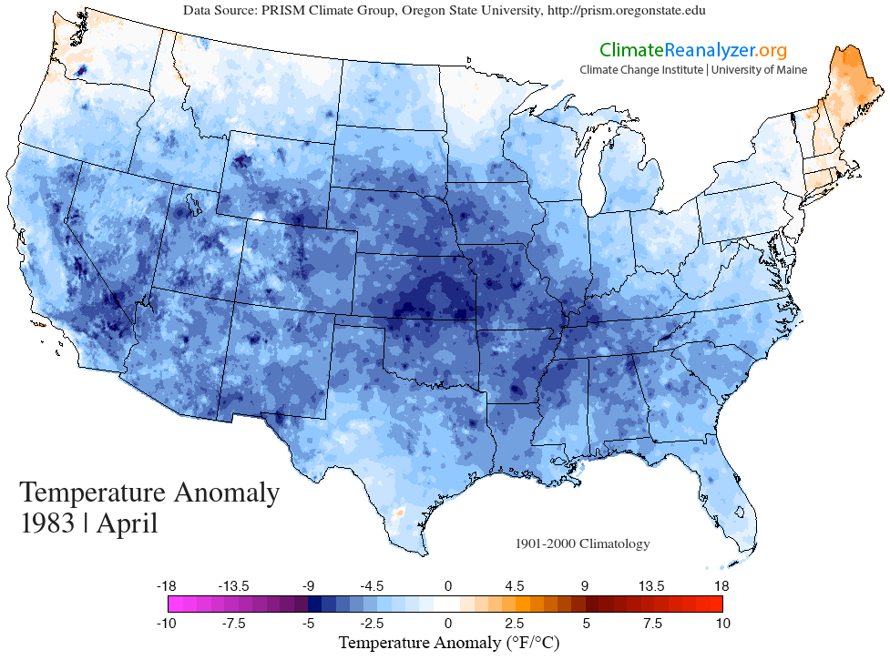
1982-83 came in just outside the Top 10 of warmest winters, so it's not far off of what we've seen or from what we're building a case with. I also find it interesting that with a cold outlook for much of the middle of the country this April, 1983 also switched to chilly weather in April! It was a brief switch, as heat roared back and brought us the warmest summer on record immediately following this chill.
There's one final element here, which is overall climate change. We know that the world is warmer overall than it was 60 years ago. This doesn't mean every year is warmer than the last, or that cold goes away. Obviously we saw that the last two winters! But in the larger scheme of things, it does increase the odds that a season or year will be warmer than average compared to previous decades. And 2016 has been blowing away records for global heat during the first three months, setting records for departures from the norm in January, February, and (coming soon) March. We can see that there's more heat to go around currently than there has ever been in modern times. Again, it's just taking a probabilistic approach here. Another check mark toward a warmer potential.
Conclusion:
I think it's very likely that this summer will end up warmer than the last two we've enjoyed. 2015 and 2014 both had a dearth of 90+ days (10 and 5 respectively) and had plenty of low humidity breaks from the heat. We should kick it up a notch this summer and have a higher risk of heat waves and also more humidity than the last two.
I also ran some rainfall numbers for all these summers, and found very little correlation or pattern among the years. They vary widely from as little as 4.15" for the entire three months, to 17.42". There was equal distribution between the drier summers and the wetter ones. Much of our summer rain has to do with tropical activity. There are always hit or miss thunderstorms around, but where the tropical moisture heads can dictate whether it's a very wet summer or not. Even storms making landfall on the Gulf Coast can have their moisture entrained into mid-latitude systems and eventually dump rain here in New England.
On that topic, we're also going to have to keep a close eye on the tropics this summer, which have been exceptionally quiet over the past few years. There are still record smashing streaks for lack of hurricanes on the East Coast, including 10+ years without a hurricane in Florida and also 10+ years without a 'Major' Cat 3+ hurricane making landfall (Wilma in 2005 is the last storm for both of these streaks). With El Nino going away and wind shear relaxing across the tropical Atlantic, coupled with warmer than average sea-surface temperatures, conditions should be right for more hurricanes to fire up and threaten the east this summer. Hopefully none come visiting, but I expect a more 'eventful' season than the past few. Good time to think about emergency preparedness as we approach the warm season.