Heavy, Wet Plowable Snow Forecast For Sunday Into Monday
BOSTON (CBS) - The idea of a late season nor'easter Sunday night and Monday has not been received all that well.
If the potential storm were a political candidate, the race would be over before it even got started. It seems the overwhelming majority are ready for spring and are done with winter. Snowblowers and shovels have been stowed away, sweaters and winter jackets put in the closet, and in many towns, spring sports are getting an early start.
If only it were that easy. If only we could just vote the storm down. Sorry Old Man Winter, we are moving on with our lives, spring is officially starting Sunday at 12:30 a.m. and we have voted you off the island. You have lost in a landslide, try again next year.
But alas, this is New England where so often winter gets the last laugh. Still, it is fairly rare for a major snowstorm to occur this late in the season. In fact, looking back at nearly 150 years of weather records in Boston, there has only been one time in our history when Boston has received a storm of 12 inches or greater after March 20th. Who could forget the April Fools storm in 1997 when 25.7 inches of snow fell during that late season shocker.
Storms of 6 inches or more have only happened 6 times (post-March 20) in Boston's history, again the last time being 1997. Even the snowy city of Worcester has only had 12 occurrences of 6 inches or more this late in March.
So, history tells us a major snowstorm is quite unlikely at this point, but this winter has been anything but "typical."
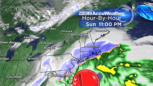
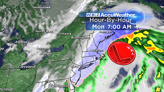
There is still a good deal of uncertainty with regards to the exact track and impacts from this coastal storm Sunday night. However, we are starting to hone our forecast as more and more good model data is becoming available the closer we get to the event.
This will likely not be a blockbuster storm. I highly doubt anyone will see a foot of snow or more. I also don't think the winds or coastal flooding will measure up to some of the other big storms we have had this winter. Winds will be strongest on the Cape and Islands (gusting to 50 miles per hour) and the coastal flooding should be minor for the most part.
Having said all that, it also doesn't look like a miss. We're likely in for a good thumping of heavy, wet snow. The exact area where the heaviest snow bands set up is still a bit of a question mark, but it appears the most likely location will be somewhere near the coast, in eastern Massachusetts. As of right now, Boston looks like it could be right in the bulls-eye.
As for what we know now:
TIMELINE
Light snow will arrive during Sunday afternoon, nothing all that important until after 4 p.m. So any plans you have Sunday morning or early afternoon should be just fine. Between 4 p.m. and 7 p.m., snow will develop, become steady, and overspread the entire area.
The peak of the storm (snow and wind) will fall between 7 p.m. Sunday and 7 a.m. Monday.
Snow should taper off from west to east during Monday morning, long gone by lunchtime.
HOW MUCH?
Right now, best estimation is for a wide swath of 4-to-8" of heavy, wet, plowable snow from Worcester-to-Boston and just about all of eastern Massachusetts.
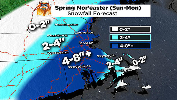
Slightly lower amounts, 2-to-4" are expected in extreme southeastern Massachusetts (including the Cape and Islands) due to some mixing with rain and generally heavier and wetter consistency, 2-to-4" also is the forecast for northwestern Worcester County and points well to the north and west.
WIND
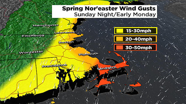
Highest winds will be over the Cape and Islands, gusts to 50 miles per hour there late Sunday night. For the rest of the area, the winds likely won't be a very big issue, gusting to 30 or 40 miles per hour along the immediate coastline and dropping off quickly as you head inland.
Some scattered power outages are possible given the heavy weight of the snow and some gusty winds.
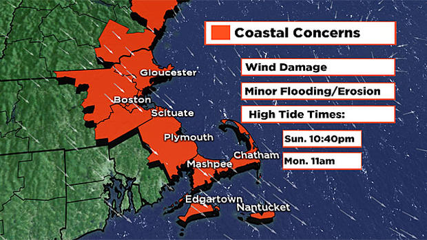
COASTLINE
Only expecting minor coastal flooding. Tides aren't very high astronomically and the storm will be a quick mover, not giving the seas much time to build. High tides to watch include Sunday night around 10:30 p.m. and Monday morning around 11 a.m.
WILL SCHOOL CLOSE?
Perhaps the second most popular question of the day after how much? Despite the storm ending during Monday morning, I would suspect if we get what we are currently forecasting (4-to-8") that there will be numerous school closings. Don't take this as an excuse not to do your homework! This forecast can and likely will change to some degree!
There is still room for a little zig or zag east or west in the storm track. We will be refining this forecast all weekend. As always I would urge you stay tuned to WBZ-TV, WBZ-AM Radio and CBSBoston.com for frequent updates.
Follow Terry on Twitter @TerryWBZ