Heavy, Wet Snow In Southern New England Likely Sunday Night
BOSTON (CBS) - Any long time, hearty New Englander should know that here more than anywhere it ain't over till it's over.
Sure, some years we get lucky and our last snowflakes fall in the early days of March. But need I remind you of a little storm in 1997 on April Fools' Day? Or, perhaps you were here back in 1977 when a freak snowstorm arrived on May 10, dropping more than a foot of snow on Worcester?
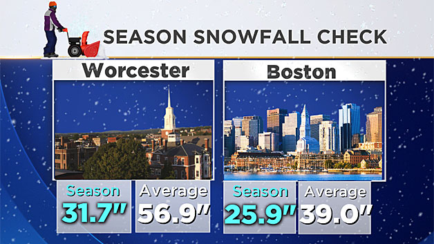
I'll say this though, this year did feel different than most. While we aren't challenging any records for least amount of snow, it's been warm, I mean really warm. Since last fall, a combination of atmospheric factors, not the least of which has been a record El Nino, have combined to give us one of the warmest stretches in our recorded history. Given that, it's certainly comes as no surprise that Boston has managed just over 25 inches of snow to this point, well over a foot below the average. And, oh by the way, about 7 feet below where we were at this point last year - incredible!
March can be a strange and fickle month though. The transition from the cold, dark days of winter to the flowery bloom of spring isn't always a smooth ride. Our atmosphere is going through several changes. The great Peter Brady may have said it best here:
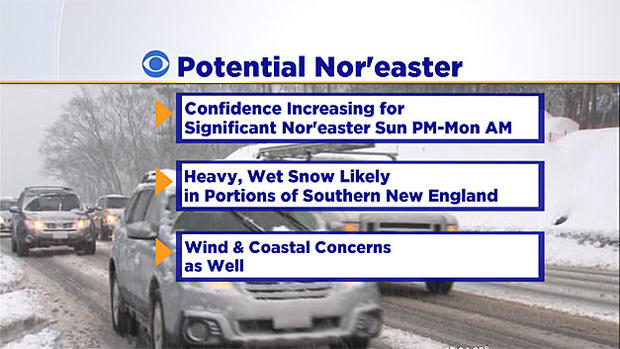
You get the point. Despite the incredibly mild winter and lack of snow to this point, we can't close the books on winter just yet. It's true that by the calendar, spring will begin this Sunday at 12:30 a.m. (the Vernal Equinox) but at the same time, a powerful storm will be emerging from the Gulf of Mexico, headed up the East Coast and most likely straight for New England.
Let me start by saying this forecast is far from being locking in.
The energy from this storm is still in pieces thousands of miles away in northwestern Canada. It will likely be another 24-to-48 hours before we can confidently forecast the track and impacts from this storm. But the chances of a complete miss are dwindling, the "cone of uncertainty" is shrinking and nearly every solution has a path that will affect New England in one way or another.
TIME FRAME:
Some light snow could start as early as Sunday afternoon.
The brunt or peak of the storm is likely to come overnight Sunday night into Monday morning.
The storm will be a fairly quick mover, cruising by our latitude by Monday afternoon and likely long gone by the afternoon commute.
TRACK:
A miss out to sea is now very unlikely, something less than 10-percent.
An "inside runner," a track well to our west, bringing mainly rain to our entire area is also unlikely, less than 10-percent.
The final solution probably lies somewhere in the middle. The center of the storm is likely to track somewhere between our coastline and just outside of the "benchmark" (40N 70W).
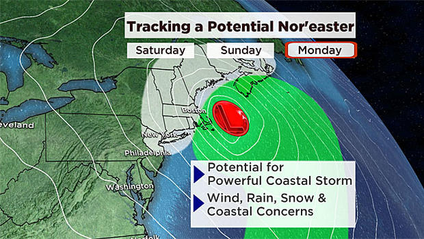
A benchmark storm would mean a good deal of snow for just about our entire area, while a coastal track would bring rain into eastern Mass. and push the heavy snow farther inland. This is still very much TBD.
IMPACTS:
Snow:
Whatever the track, there is likely to be some heavy, wet snowfall somewhere in New England from this storm. Where that band of snow sets up, there could be some power outages from the weight of the snow combined with gusty winds. It's way too early to get into snow amounts, but 6-to-12 inches is a real possibility somewhere in southern New England.
Wind:
There will almost certainly be some significant wind in southern New England Sunday night and Monday. This may be a nor'easter-type event with strong, gusty east-northeast winds along the coastline. Even as the storm passes by and the winds shift to the north and northwest, winds will likely remain very strong and gusty. Winds to 50+ mph are a real possibility near the coastline.
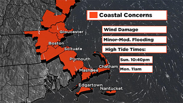
Coastal Concerns:
Astronomical tides are not all that high. High tide cycles to watch: Sunday night between 10 and 11 p.m. and Monday morning around 11 a.m. With a track near or just off our coast, minor to moderate coastal flooding is likely during those time periods. Beach erosion is also a concern.
Clearly there are still numerous questions surrounding this event.
At this point, best thing you can do is stay tuned to forecast updates for the rest of this week and, of course, over the weekend. Make preparations for a potential nor'easter Sunday night and Monday. If you are scheduled to travel during that time, you may want to consider altering those plans, or at the very least begin to prepare for an alternative.
As always we will keep you updated on WBZ-TV, WBZ NewsRadio 1030 and CBSBoston.com.
Follow Terry on Twitter @TerryWBZ