East Coast On The Storm Watch This Week
BOSTON (CBS) - One of the more recent blog posts I put together was about how winter was slowly taking the reins. A little colder, some more of that biting mid-winter wind, a few more snowflakes. The progression continues this week with the few inches we picked up Sunday night and the coldest stretch of temps we've seen since last February. Then our attention turns to the end of the week, where the first major snowstorm of 2016 may be lurking. I'm sure by this point you've seen all sorts of hoopla and snow maps and all those sorts of things that fly around when a storm is on the table. The point of this post is to look at the knowns and unknowns, what we're most confident of, and what we should be on the lookout for as the weekend draws near.
Confidence Is Higher Than Usual
Let's start with arguably the most important element - that confidence is unusually high for a major event this many days in advance of its onset. This isn't one of those 'may or may not develop' situations or 'timing is key' situations. It's more of a 'all the players are coming together, how will they manifest themselves?' kind of situation. All the dynamics you could want for a big snowstorm in the east are at nature's disposal. And more remarkably, almost every single model and most ensemble guidance are all on board. That's definitely a red flag for a potent system.
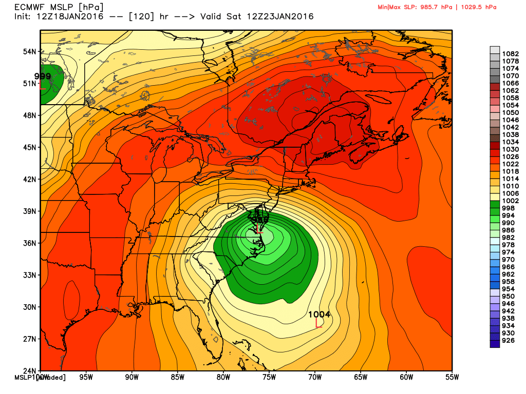
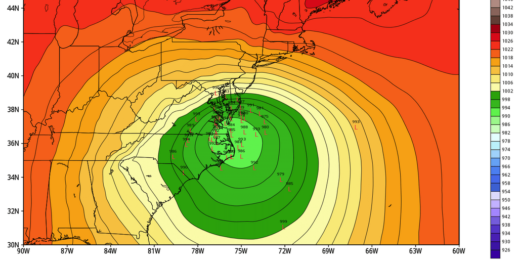
The ECMWF model currently shows a pretty classic snowstorm setup for the Mid-Atlantic into New England. Strong high anchored over SE Canada will help slow the system down and keep the cold air in place. Source: Weatherbell
Unlike any other setup so far this season, we have an ample supply of cold air out ahead of the storm. And we also expect a strong area of high pressure to keep it in place. That's been a major missing ingredient to date. The old adage of 'forecast the high, forecast the storm' works here. The strength and exact placement of that high will help determine the speed and movement of our storm. It will likely slow it down and produce a multi-day event.
We have phasing of the 2 streams (polar and subtropical), a storm potentially becoming vertically stacked and cut off...or in other words a storm that will become all wrapped up and mature along the East Coast. Really, everything we need is in play. Like any good dinner recipe, it starts with the ingredients.
Very Large Snow Totals Are Possible
A slow moving and dynamic storm? You bet there will be some big time snow totals. The question is - will those big totals get into New England? Right now the best bet for some serious snow (for the sake of this writing, let's say 'serious snow' is over 18") is in the Mid-Atlantic region. The places I'm most interested in are from Virginia to the DC area, West Virginia, Maryland, central/eastern PA including Philly, and northward into the NYC metro area.
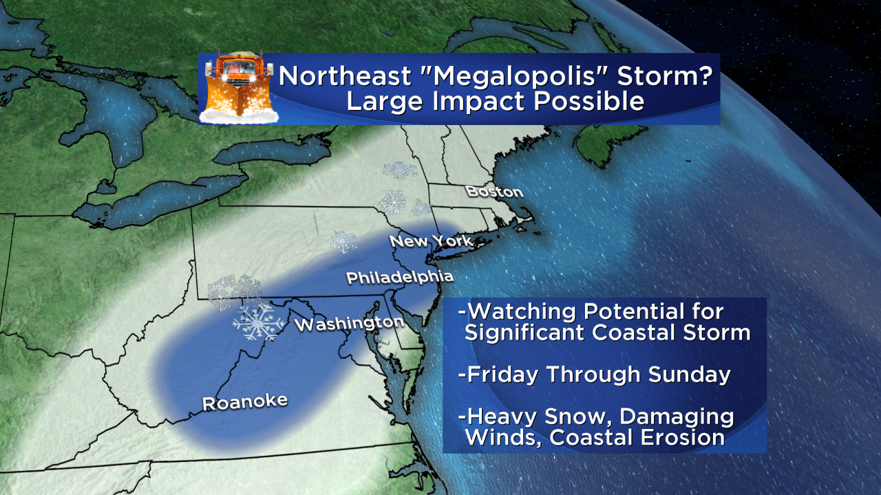
Shaded in blue, the areas that currently have the highest risk for major snowfall Friday-Sunday.
Where does that leave New England? Well this is different than the run of storms we had last year. Almost all of those 'bombed out' or rapidly developed right here off our coast. Home grown! They barely affected anyone else. So we had many rapidly intensifying events producing prolific snowfall rates. That won't be the case here. This storm will be undergoing that stage in the game down off the North Carolina/Virginia coast. So what comes this way is a little more in question. On the one hand, we could be under the influence of this for a long time - perhaps 36-48 hours from early Saturday through Sunday. On the other, the snow rates likely won't be as high as they could be south of us, and a mature storm has other issues to contend with like how the dry slot develops, where the arm of heavy precip will set up shop, etc.
Right now I certainly think we have a good shot at our largest snow event of the season, but I don't think it would be up there with those insane 24-36" snowstorms we had last winter. A lot can change over 4-5 days, but that's how it looks at the moment.
Coastal Concerns High For Erosion and Flooding
Probably the most concerning element of this storm in New England (as well as New Jersey up to Long Island) is the potential for serious flooding and erosion at the coast. Current signs point to a slow moving storm that could even cut off completely for a time and stall/loop around, which is a recipe for long duration strong winds. This on its own can produce issues, but we also have a full moon on Saturday. So right at the height of the storm, we get some of the highest astronomical tides of the month. When you put together a long fetch and duration of onshore winds and already high water levels, you've got problems.
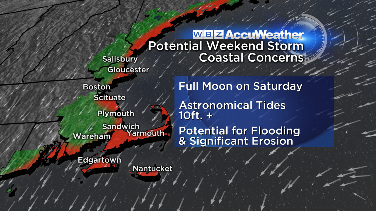
So with the disclaimer that certainly this could change a bit in the coming days, I'd advise anyone along the coast to stay up to speed on the flooding/erosion impact. Potential is there to really chew up some of the shoreline over multiple tide cycles.
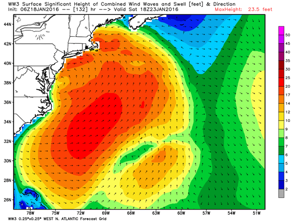
NOAA's wave model showing a lot of chop in the Atlantic this weekend and an onshore flow for us here in New England. Source: Weatherbell
What's Most Likely To Change?
As is almost always the case in this forecast range, it's the track. It's always the track. There's EXCELLENT agreement on the early stages, with a powerhouse low forming near the Delmarva. So how about after that? Looking at ensembles (multiple members of one model suite, all perturbed slightly), most of the clustering is found on the NW side of the track. This suggestions that the storm may try to hug the coast more instead of tracking farther out into the ocean. That kind of track does make sense with well above average ocean temps and a sharp baroclinic zone (big temp spread over short distance) forming for the storm to move along. If this ends up being the case, we'll have more of a rain/snow line in play for the I-95 corridor. The ocean is still quite 'warm' for this time of year, and a powerful storm would push coastal fronts inland. That puts DC/Philly/NYC/Boston on the edge of snow/rain/both.
There is very solid agreement for a storm this far in advance, with a cluster of solutions west of the 'mean.' Source: Weatherbell
There are also still several ensemble members with little to nothing in New England. I don't really see this as a likely scenario right now, but it does go to show the uncertainty that's still in the forecast. I'd like to see a little more agreement between all those members before really clamping down on the impacts here at home.
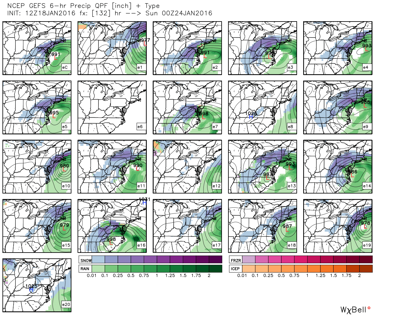
Overall model agreement across the board is high, but there are still some that aren't fully on board or which take different tracks. Seen here is the GEFS. Source: Weatherbell
Your Bottom Line
Don't go re-arranging your life yet.
I can tell by the emails/tweets we get that there's always a lot of trepidation when a storm is in the offing. We don't put info out there to freak everyone out. It's to try and put the best stuff we have at the time out there so people can make well informed decisions. If you have flights, parties, travel concerns, etc in New England this weekend I'd just keep abreast of any changes in the forecast over the next couple of days. More clarity will likely come on Tuesday, with an even better picture by Wednesday. Up until that point I hope this outlines the potential hazards so you know what may be coming, and then you can put any plans or changes into action as the forecast confidence grows!


