Eye On Weather: El Niño A Big Player In Winter Outlook
Find Eric Fisher on Twitter and Facebook
BOSTON (CBS) – By this point, you have probably heard all manner of things blamed on El Niño. We've all seen the headlines, many of them not so scientifically accurate (Godzilla El Niño!). But there's no doubt that a powerful El Niño has been helping to shape weather across the globe over the past several months.
Read: Eye On Weather Special Reports
A coral bleaching event is underway, fires are raging in Indonesia, and the Atlantic hurricane season was held in check with high shear over the Gulf of Mexico and Caribbean. These are all expected impacts from a strong El Niño. Around here, we've all noticed the lack of a winter feel this December, which is off to an incredibly mild and snowless start. A slow beginning to winter here in the Northeast is a hallmark of strong El Niño events.
So what actually is this phenomenon? Not just 'the Niño' (in Spanish it actually means 'the boy child') El Niño is a phase of ENSO – the El Niño Southern Oscillation. In an El Niño situation, trade winds reverse in the equatorial Pacific and start blowing west to east toward the Americas. This brings extremely warm water from the general vicinity of Indonesia toward the eastern Pacific. As warm water builds at the surface, it acts as a cap to prevent colder water underneath from upwelling. What results is a large pool of well above-average water that can impact much larger global circulations. The opposite end of the spectrum is La Nina, when this region of water encounters a period of cooling.

Source: NOAA Climate.gov
The warmer-than-average sea surface temperatures lead to increased evaporation rates, which in turn leads to more warm and moist air rising in the equatorial Pacific. This energizes the subtropical jet stream, which then helps to direct this mild and moisture-laden air toward the U.S. The end result is often a stormy southern tier of the country and fewer intrusions of the polar jet stream diving down from Canada and delivering shots of arctic air. In fact we've been seeing it in action all week as an atmospheric river originating in the tropics has been spraying the Pacific Northwest with huge amounts of rain and snow. Meanwhile, the country has been basking in amazingly widespread December warmth.
So El Niño Is Here - What Will It Mean For Us?
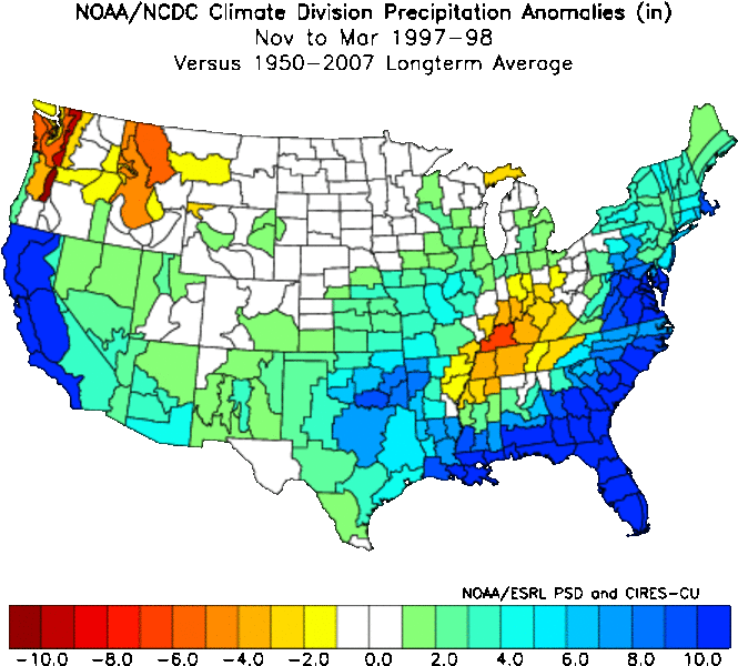
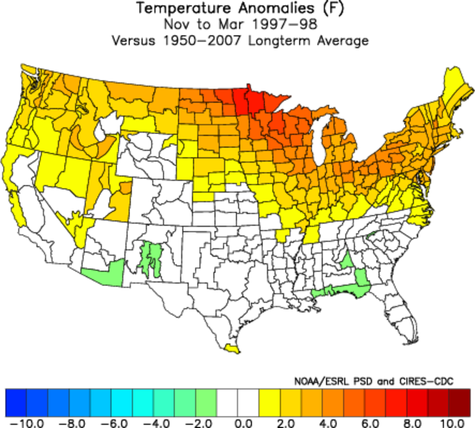
In general, this setup leads to a milder than average winter with less snow than average in southern New England. There have been 6 'strong' El Niños on record (3-month values of the Nino 3.4 index of +1.5ºC of greater). The signal isn't as strong as, say, the one for a stormy pattern in the southern U.S. But we do see that the strongest events feature below average snow. In the especially strong 1997-98 El Nino, the city picked up a measly 25.6″. Sounds like just one of the blizzards we had last winter! This and the warm November setup are indicators in the corner for below average snowfall.
STRONG EL NINOS
Year Snowfall (Seasonal) Winter Avg Temp (DJF)
1957-58 44.7″ 32.2F
1965-66 44.1″ 32.1F
1972-73 10.3″ 31.5F
1987-88 52.6″ 32.0F
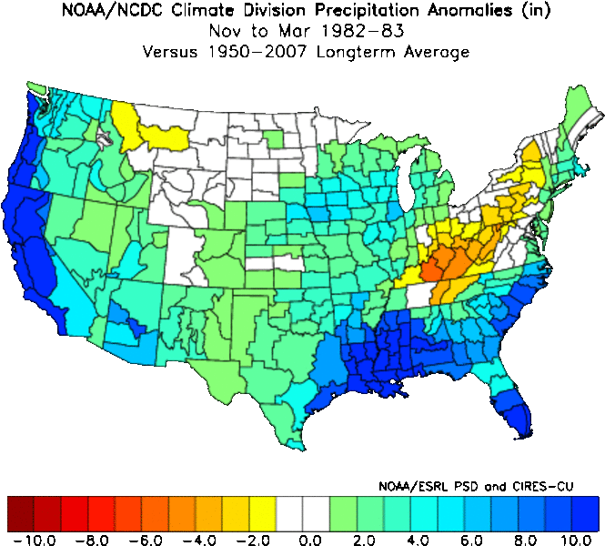
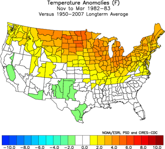
1982-83 32.7″ 34.5F
1997-98 25.6″ 34.8F
In terms of temperature, every one of these winters were above average (average winter, DFJ, temperature is 31.3F since observations moved to Logan Airport in 1936). It's interesting to note that the two strongest El Niños, which were also the most recent, had well above average winter temps in the Boston area. 1997-98 produced the 8th warmest on record in the city. It's believed that strength of the El Niño has a lot to do with the results…not just whether or not it exists. So having an extremely strong one in place helps produce a clearer picture for us. Keep in mind that seasonal temperatures are averaged over three months. Just because we expect it to be a warmer than average winter doesn't mean that there won't be your typical cold shots of arctic air. They just likely won't be as persistent as what we saw in the last two winters.
Where Does The Current El Niño Stand?
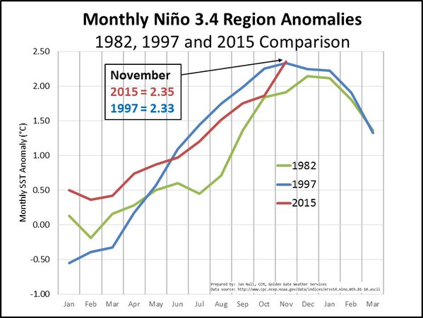
Indications are that the current El Niño has peaked and is starting to decline. It reached a max (record) anomaly in late November for region 3.4, and the SOI (Southern Oscillation Index) has fallen sharply since then. So the one we're seeing now is peaking earlier than the very strong events of 1982-83 and 1997-98. A weakening trend is expected to continue as we head deeper into winter, and this may help open the door to a second half recovery to more typical winter conditions here in New England. That remains to be seen, but signs are certainly there for a colder and more active situation in January and February...perhaps all the way into March. This is where our highest snow chances will present themselves.
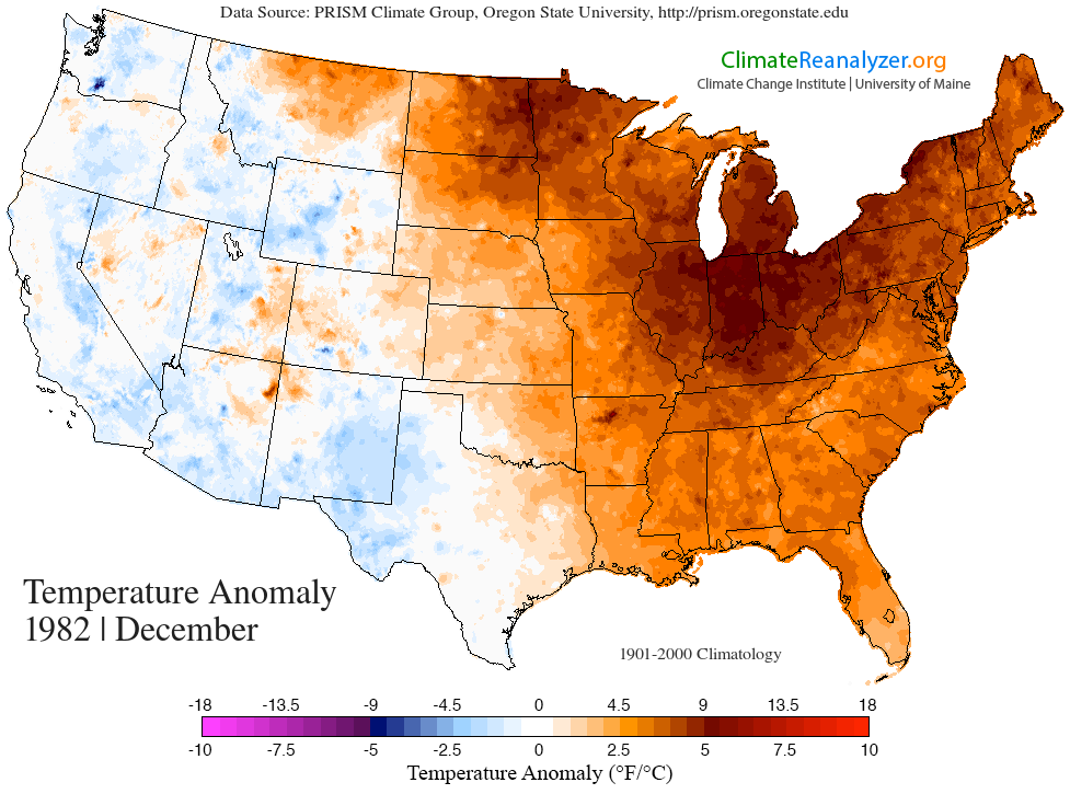
No two events are the same, and El Niño is not the only factor that goes into the outlook. We can't say that it has all the answers. But when looking for similar setups (analogs), this one resembles 1982-83 most closely. That season saw a mild November, a very warm (and strikingly similar) December, and ended up with 32.7" of snow in Boston; 63.4" in Worcester, and 46.4" of snow at Bradley International Airport in Windsor Locks, CT. All below average, but not by much. A good portion of that snow came in a huge Northeast blizzard February 10-12th. This kind of idea mirrors our outlook for the 2015-16 season.
While we're off to a VERY slow start, a strong storm or perhaps two should help us recover to near average snow totals. Winter is not canceled! It's just biding its time.
Join the WBZ-TV Weather Watcher Network. Apply here.