Hurricane Joaquin Track Still Not Certain
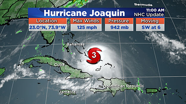
BOSTON (CBS) - Hurricane Joaquin strengthened rapidly Wednesday evening becoming a major Category 3 storm, the second to attain major status this season in the Atlantic.
View: Hurricane Tracking Maps
The reason for its quick intensification? Warm water and a lack of wind shear.
Just like cars need gas to run, hurricanes use warm water as their fuel - and the water Joaquin has been wobbling over is 84-to-88 degrees! Wind shear is something that hurricanes don't like. Wind shear is the change in wind direction with height in the atmosphere; increased wind shear means the convection and tops of the clouds get blown off. A high wind shear environment is not conducive for hurricane strengthening, whereas low wind shear means the hurricane can "do its thang," so to speak.
The latest forecast track from the National Hurricane Center has shifted east from when we last updated you Wednesday. There are a few reasons for this, primarily, some of our most "trusted" weather guidance has also shifted east AND several of the dozens of hurricane models are split, from a landfall near the Carolina coast to out to sea.
In other words, there remains considerable uncertainty with the track of Joaquin.
Right now, the Bahamas are being battered with hurricane force winds, rainfall that could exceed 15 inches in some spots, along with a storm surge that could raise water levels as much as 5-to-8 feet. Hurricane Joaquin will slowly meander near the Bahamas through Thursday night before taking that all important turn to the north.
No matter what path Joaquin takes, there will be high surf up and down the East Coast.
If Joaquin tracks closer to the eastern seaboard and takes a turn for New England, the results would be quite different. While Joaquin would weaken considerably, flooding rain and damaging wind would be possible, along with a surge at the coast. I can't emphasize enough how critical the exact track will be in determining specifics details on what we can expect here at home.
This is a high stakes forecast. But this is what we do. Our entire team will stay on top of the very latest track and update you here and on WBZ-TV until there's a more concrete solution.
Follow Danielle on Twitter @DanielleWBZ4