Tropical Storm Erika: U.S. Impact Or Out To Sea?
When the internet is full of storm track graphics and satellite loops, you know it's tropical season.
And for the casual observer, it's really tough to cut through all the noise and figure out what the heck is going to happen. There's always inherent uncertainty in a tropical forecast. But the effect gets amplified when you see tons of squiggly lines on TV, 'worst case scenario' images being posted, and forecasts from all manner of sources from seasoned meteorologists and government agencies, to any weather enthusiast with access to a computer. You might say 'well isn't this just one more of those?'. Yes. But hopefully I can clear up any confusion as to what this storm is all about. If not, feel free to ask any questions!
http://www.ssd.noaa.gov/PS/TROP/floaters/05L/imagery/rbtop_lalo-animated.gif
For starters, Erika is a fairly large storm. The circulation has been much more robust than Danny last week, even though it's battling some of the same environmental factors. It has had to fend off some dry & dusty air, and there's westerly wind shear that's been blowing across the storm. Wind shear is bad for storms (and good for us) because tropical systems like to be 'stacked.' They're heat engines, and they like a constant vertical transport of heat from the surface upwards to keep its storms firing and circulation intact. When you have high wind shear, it throws everything off and keeps a system from intensifying. Wind shear has been quite high over the Caribbean (record levels), which is very often the case during El Nino years. It's tough to get tropical formation in the Caribbean during a significant El Nino.
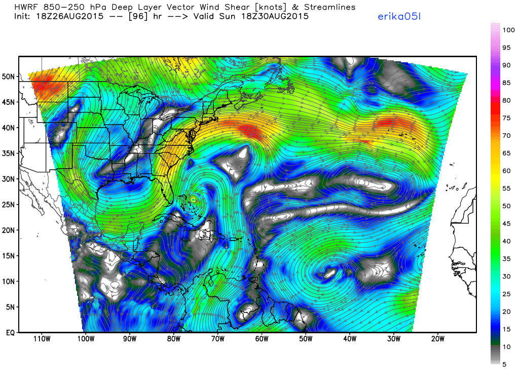
Wind shear guidance on Sunday afternoon. Notice the little pocket east of Florida that Erika could flourish in. However, conditions right along the coast are more hostile, and the steering currents would eventually take Erika out to sea away from New England. Source: Weatherbell
Erika will keep battling this through Thursday and into Friday. But IF the storm can survive into the Bahamas, it will move into a more favorable area for development. The circulation will find itself underneath a ridge of high pressure, where wind shear is lower. Not only that, but the water is VERY warm around the Bahamas and off the coast of Florida. This means that if Erika can just barely crawl its way into the Bahamas, it will have the opportunity to get its act together in a hurry. A situation like this can be quite difficult to forecast and also difficult to prepare for. You may have a storm that looks ragged and nearly finished off, but then 24 hours later you have a strong hurricane. It doesn't take much this time of year.
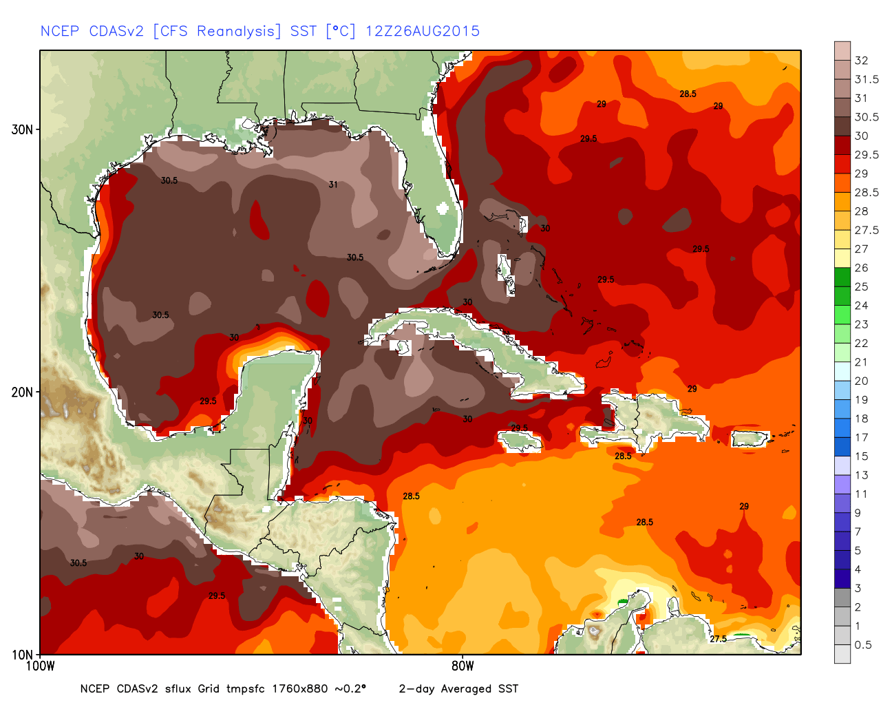
Sea surface temperatures along the southeast coast. Temps around 30-31C can help translate to rapid intensification (in the absence of strong wind shear). Source: Weatherbell
So considering these factors, anyone in the Bahamas should be preparing for a possible hurricane. Before that, tropical storm conditions will move through the Leeward Islands, Virgin Islands, and likely graze Puerto Rico at the very least.
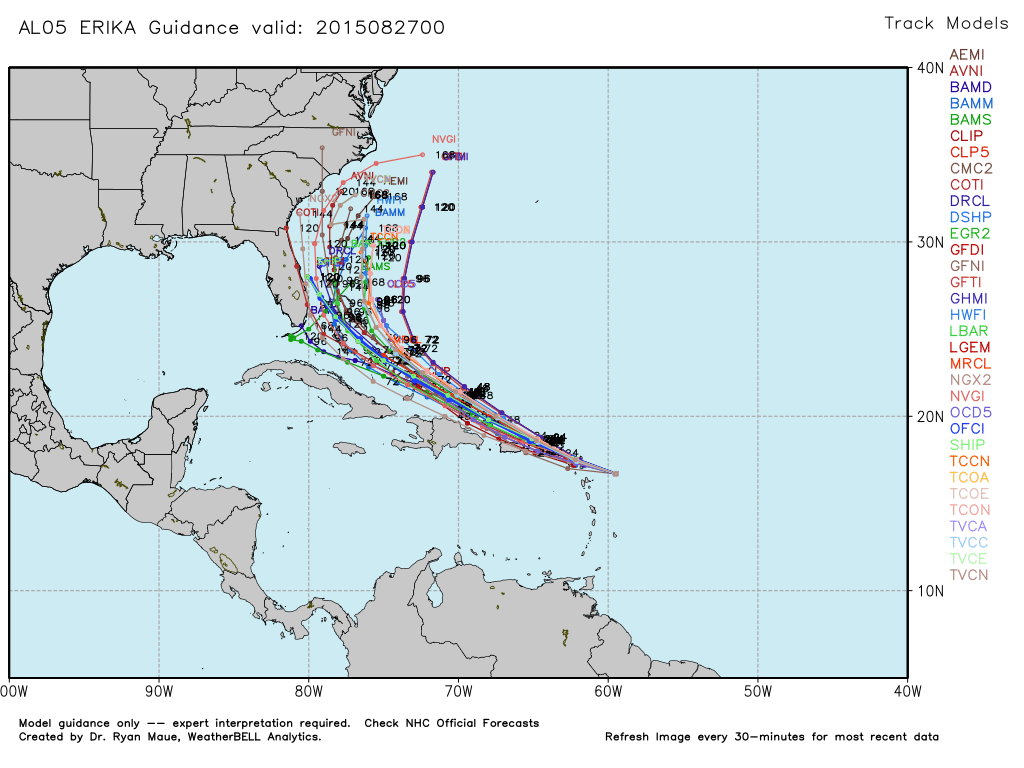
Will Erika strike the U.S.? That part of its story is still unclear. Models have been trending toward a strong re-curve, taking the center of the storm very close to the southeast shoreline...but not making landfall. Since we're talking early next week, this scenario is not set in stone yet. Anyone from Florida to North Carolina should be keeping a close eye on the storm's progress and any forecast updates over the next couple of days. Even a glancing blow from a strong hurricane could bring heavy rain to the coast, heavy surf, and erosion.
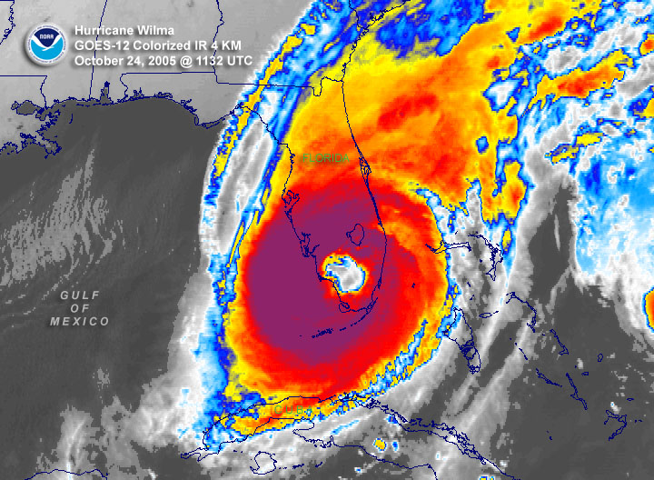
Hurricane Wilma makes landfall in October of 2005. Source: NOAA
*An amazing sidebar to a potential landfall is that Florida hasn't seen a hurricane come ashore in TEN years! The last to do so was Hurricane Wilma in October of 2005 (also the last 'Major' Cat 3+ hurricane to strike anywhere in the U.S.). That's a record stretch by a long shot, and incredible considering Florida's vast shoreline and tropical location. To put this into perspective - I wasn't even a meteorologist yet when Florida saw it's last hurricane. Still a college geek just hoping to get a job someday.
In New England, the current thinking is that any impact is unlikely. A strong ridge in the jet stream will be building over the Northeast, blocking Erika from lifting northward into our waters. Indications are for a sharp re-curve, which would take Erika just off the Florida coast late Sunday night/Monday, drift slowly for a couple of days very near/parallel the southeast Atlantic coast, and then sharply veer out to the east into the open ocean.
It's never wise to write off a tropical system a week in advance, so we'll be keeping a close eye on it through the weekend. Slight changes in intensity and track can have tremendous impacts. Just look at some of the Katrina info that's floating around the internet this week. A storm that was supposed to ride up into Florida for a 2nd sunshine state landfall ended up being adjusted all the way west to New Orleans. But for now, the highest risk looks to be in the Bahamas and then the SE coast of the U.S..
Stay tuned.


