El Nino Is Here. What Will It Mean For New England?
Find Eric Fisher on Twitter and Facebook
Okay, now that we've got that classic out of the way, let's talk about the current buzz surrounding this phenomenon. Not just 'the Nino' (in Spanish it actually means 'the boy child') El Nino is a phase of ENSO - the El Nino Southern Oscillation. In an El Nino situation, trade winds reverse in the equatorial Pacific and start blowing west to east. This brings extremely warm water from the general vicinity of Indonesia toward the eastern Pacific. As warm water builds at the surface, it acts as a cap to prevent colder water underneath from upwelling. What results is a large pool of well above-average water that can impact much larger global circulations. The opposite end of the spectrum is La Nina, when this region of water encounters a period of cooling.
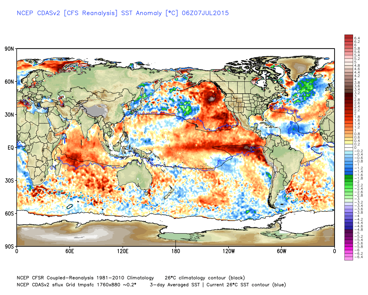
Current SST anomalies. Incredible warmth building in the Pacific, with colder than average Atlantic temps. Source: Weatherbell
Currently, we're seeing significant warming that began several months ago in this particular region. Not only have we seen extremely strong westerly wind bursts pushing more warm water toward South America, but forecasts have all come in line to project more warming ahead. In fact, the general model consensus is for a strong El Nino, perhaps even an all-time record strength event as we head into the fall and winter. To be fair, that doesn't mean it's a slam dunk. Last year models did a fairly poor job of predicting how things would evolve for 2014-15. But now that we're actually seeing conditions mirror the expectations, it's a more solid bet that a strong El Nino is on the way.
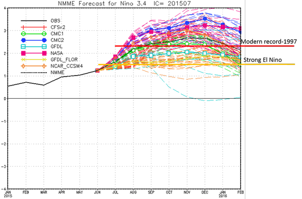
NOAA agrees, issuing an outlook on Thursday which said there's a 90% chance that El Nino will continue through the winter of 2015-16, and an 80% chance that it will last into the spring of 2016. They also point out that a significant El Nino in excess of +1.5ºC in El Nino region 3.4 is expected. No doubt, this will have some consequences on weather over a large part of the world.
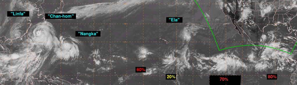
Typhoons and tropical waves lined up across the Pacific on Thursday afternoon. Source: NWS Ocean Prediction Center
For starters, it's helping to light up the Pacific tropical season. Cyclones have been lining up all across the ocean and putting on quite a show from space. Meanwhile in the Atlantic, all is quiet. That's a telltale sign of El Nino, because the warmer Pacific waters lead to the production of an active subtropical jet stream and strong wind shear over the tropical Atlantic. Not only has wind shear over the Caribbean been at record high levels, but it's been even stronger than the average wind shear seen in January! This is putting a cap on any hurricane development, and nothing is expected in the MDR (main development region) anytime soon. To go along with El Nino issues, sea-surface temperatures are also cooler than average and there's a ton of Saharan dust flying over the Atlantic. All good news from the U.S. perspective.
In terms of our day to day weather, El Nino starts to have a bigger Lower 48 influence heading into the fall and winter. You've probably seen the headlines about California, because El Nino tends to bring much wetter than average weather to the state (and in the case of the record setting 1997-98 El Nino, epic flooding). It also keeps an active subtropical jet blowing across the southern tier of the U.S., with above average precipitation and cooler than average temperatures there. In New England, the picture isn't quite as clear. Will we see an impact? If there's a strong El Nino, absolutely. But it's a lot harder to predict.
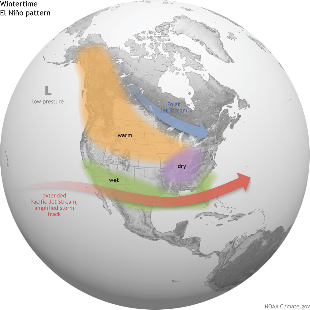
Source: NOAA Climate.gov
In general, this setup would mean a milder than average winter with less snow than average in southern New England. There have been 6 'strong' El Ninos on record (3-month values of the Nino 3.4 index of +1.5ºC of greater). In all of those years, Boston has seen below average snowfall. In the especially strong 1997-98 El Nino, the city picked up a measly 19.5". We had several individual storms that produced more than that last year!
STRONG EL NINOS
Year Snowfall (Seasonal) Winter Avg Temp (DJF)
1957-58 44.7" 32.2F
1965-66 44.1" 32.1F
1972-73 10.3" 31.5F
1987-88 52.6" 32.0F
1982-83 32.7" 34.5F
1997-98 25.6" 34.8F
In terms of temperature, every one of these winters were above average (average winter, DFJ, temperature is 31.3F since observations moved to Logan Airport in 1936). It's interesting to note that the two strongest El Ninos, which were also the most recent, had well above average winter temps in the Boston area. 1997-98 produced the 8th warmest on record in the city. It's believed that strength of the El Nino has a lot to do with the results...not just whether or not it exists. So we'll need to monitor how this situation progresses over the next several months.
The other likely outcome of El Nino will be a record warm year for the globe. Temperatures to date are already well above average for the Earth as a whole, and odds are 2015 will go down as the warmest year on record.
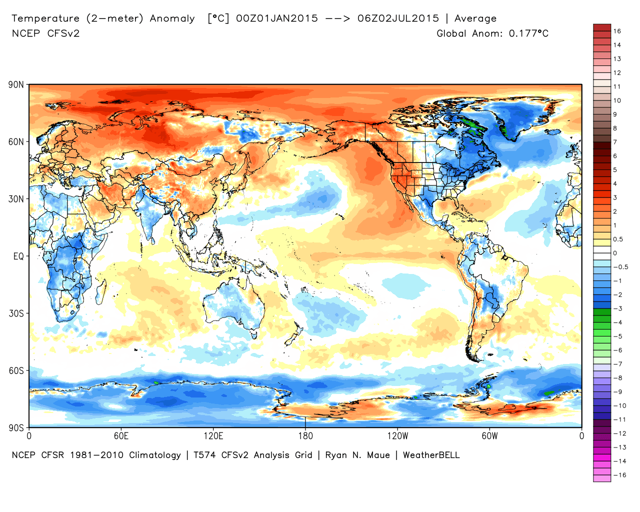
Year-to-date temperature anomalies. Source: Weatherbell