Climbing Out Of The Deep Freeze
Find Eric Fisher on Twitter and Facebook
We've checked off quite a bit on our winter notables list. Snowiest month, coldest month, snowiest stretches, most consecutive days with accumulating snowfall, a couple Top 10 snowstorms, a pair of blizzards, to name a few. Still waiting on that pesky snowiest season on record accolade, but I suppose there's still some time to finish the job. Let's just say quite a few people want to start talking about when all of this ends, and we may have some improving news on that front.
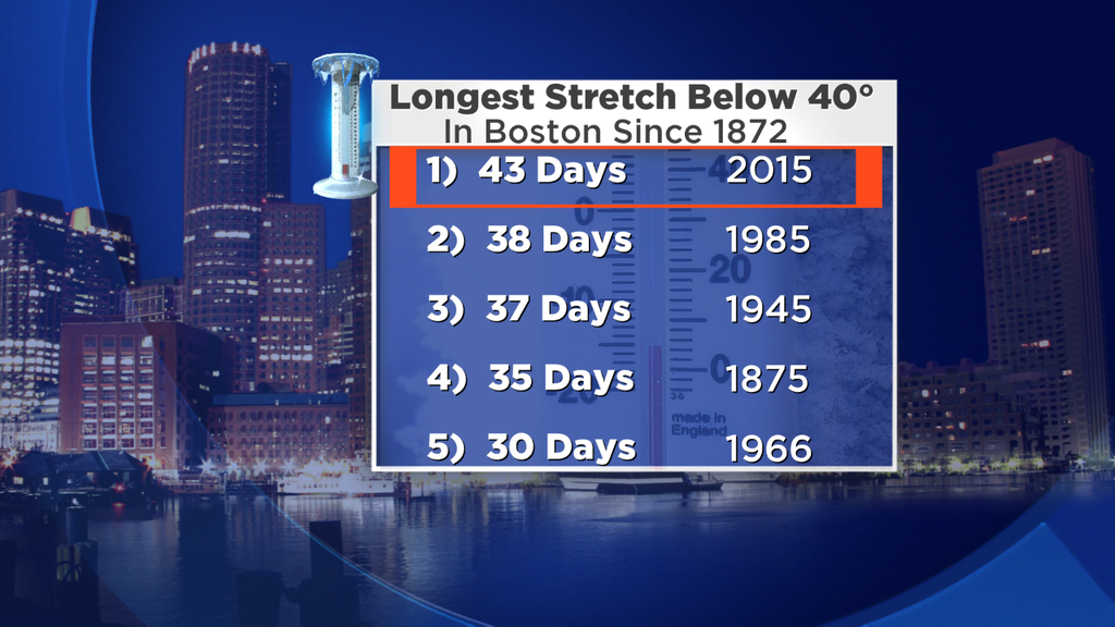
In the short term, how about a shot at 40 degrees today? The last time it happened in the Boston area, the Patriots were still finishing their AFC Championship champagne. It was January 19th, it hadn't even really snowed yet this winter, and some were wondering if it would be the season without snow at all. We know how that story ends. Well today we should finally reach that Mt. Everest of winter 2015 temperatures again. It's not much, but it's a start. Let's just skip over the two very chilly days in the 20s for Thursday and Friday for the sake of our sanity, and get to the pattern change stuff.
For this weekend, it's the same general idea we've been living with over the past two months. Trough in the jet stream hanging out over the Northeast. BUT, it's a drier trough. Less vigorous energy diving down and not bombing out near the coast, and so all we get are passing clouds and a couple chances for snow showers/flurries Saturday through Monday. All the while, highs will make it into the 30s. The 30s! It's been tough to even string together 3 days of temps in the 30s for the better part of the last 7 weeks, so no complaining. With the increasing sun angle that's comparable to early October, it'll help to slowly decrease our snow pack - the ultimate goal. PLUS we get Daylight Saving Time as we 'Spring Forward' early Sunday morning. Twilight until 7pm? Yes please.
That brings us to next week, which is looking like what the doctor ordered. Again...not a whole lot of big storminess is lurking out there. Through Thursday we may stay mainly dry with highs in the 30s and 40s, and that's precisely what we want. Releasing some of the 4-6" of liquid equivalent that's locked up in our snow pack during the day, and slowing that process down at night. The 30s and 40s feel excellent at this point, and I'm sure more than a few Boston Marathon trainers will be happy to run without their faces freezing.
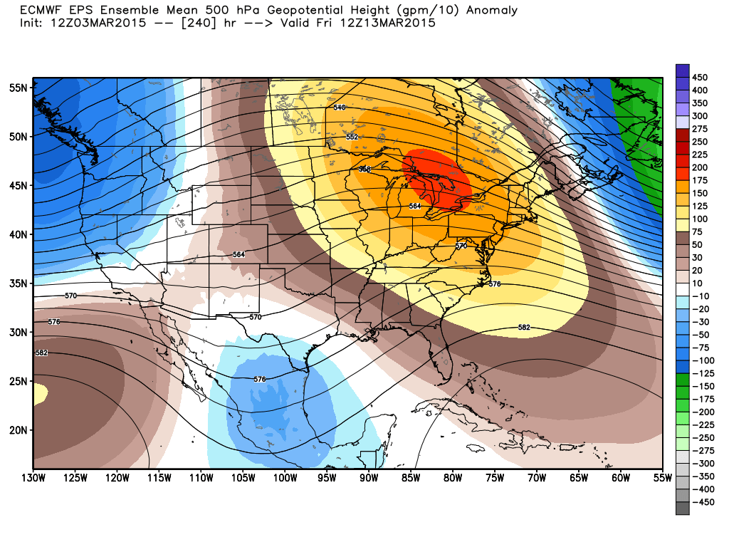
ECMWF Ensemble Mean 500mb height anomaly at the end of next week. Shows a ridge building eastward into the Northeast. Likely not a permanent feature, but should allow for a reprieve from the arctic express we've been dealing with! Source: Weatherbell
Things get more interesting in the middle of the month. Most models have been strongly hinting at a ridge developing in the middle of the country, and that's where the highest probability of some real warmer temperatures will be. However, there's a decent chance that some of that warmth and ridging will be able to build over the Northeast, at least for a little while. At the same time some potential rain events will start to crop up toward mid-month, too. I think this is the first time I've written 'warmth' and 'rain' in the same blog since December.
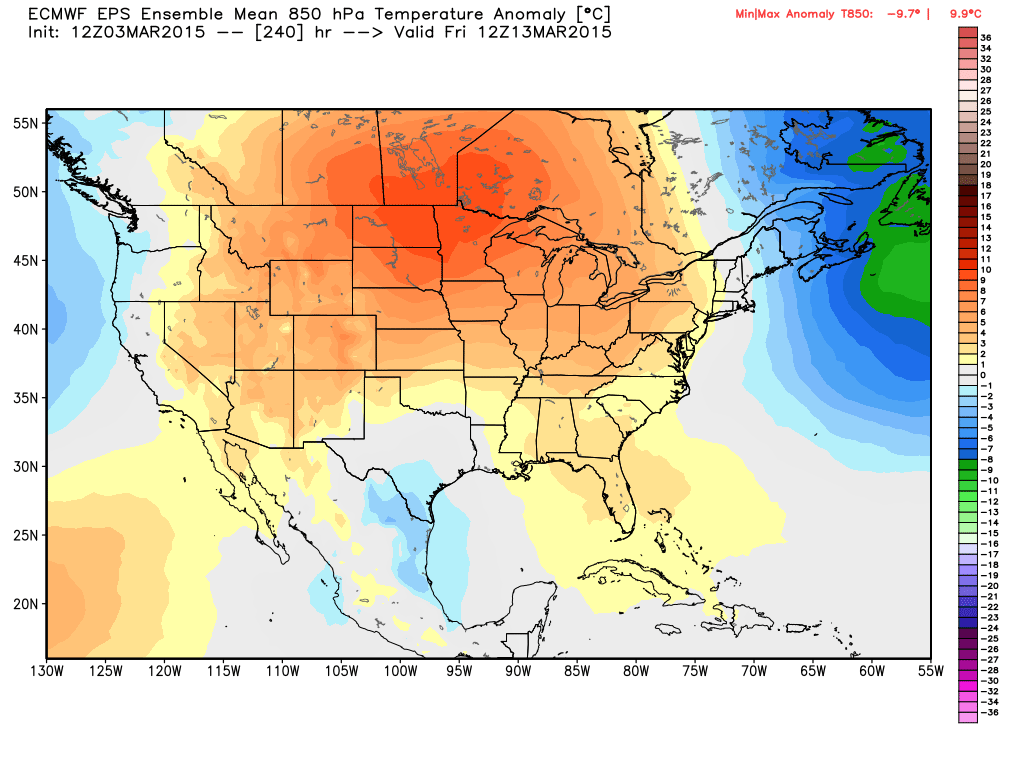
ECMWF Ensemble mean 850mb temp anomaly. Basically, we look at these to see where warmer than average air masses are aloft, which can many times mix down to the surface (that depends on the exact setup...sometimes inversions or a cold ocean wind can put a stop to this). The middle of the nation is definitely expecting a warm-up...and we'll get one relative to what we've been dealing with too. Source: Weatherbell
I'm not 100% bullish on a real 'torch' scenario with us seeing strikingly warm temperatures with this pattern flip, but I do think it's going to start to feel a whole lot better. Keep in mind that by next weekend, the averages in Boston are a high of 47 and a low of 32. I can't even remember what that feels like. So even *average* temps by that time frame would feel most excellent. If we can actually achieve a few days of above average readings, that means 50s for us. People would hug each other in the streets, dogs and cats would call a truce, and spontaneous flash mobs would break out to celebrate the occasion.
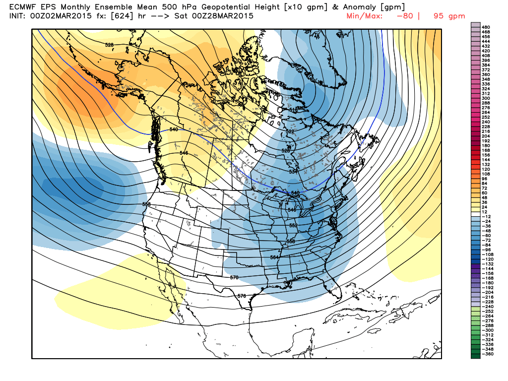
Return to the same old game? ECMWF weeklies show a strong trough signal returning to the eastern U.S. to end the month and start April. Would bring more storminess and colder temps. Source: Weatherbell
This warmer pattern may not be able to hold for long as the ECMWF weeklies and CFSv2 hint at some colder than average temps and troughing returning to the Northeast for the end of the month, but it's definitely something to still look forward to and a sign of hope that winter is slowly running out of gas. Even a 'below average' day at the end of the month is still in the 40s...and not racing forward into very warm temps will hopefully keep our flooding concerns at a relative minimum over the next month. Something we'll be keeping a close eye on.

CFSv2 sub-monthly look at temperature anomalies for the end of March and start of April. At least 'average' isn't so cold anymore by this time frame. Source: Weatherbell