Another Powerful Storm Threatens New England
BOSTON (CBS) -- I have officially run out of ways to discuss and describe this winter. By now you have likely been hit with a thousand different numbers and graphs.
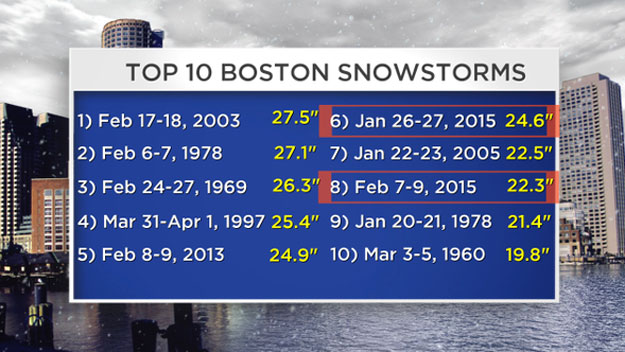
Top 10 snowiest winter. Two top 10 storms in the last three weeks. Snowiest February on record. . . yadda yadda yadda. . . the beat goes on and on.
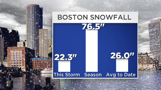
The history books are literally being rewritten over the last 3 weeks. I find it incredible to think that just 20 days ago we had just 5" of snow for the season and now we are completely and utterly buried. We are dumping snow in "snow farms" and in the Atlantic Ocean. Day and night dump trucks are hauling snow out of the city and yet we just cannot keep up.
More than once I have woken up and wondered if the last few weeks had really happened. I mean really? More snow in 17 days than in any 20, 30 or 40 day stretch in history? More snow in 17 days than we get in a full season and a half?
What is more believable, that or the Patriots winning their fourth Super Bowl thanks to a rookie most of us have never heard of making a miraculous interception with seconds to go from the 1 yard line? You could have told me this whole story three weeks ago and I would have said you are nuts.
Well, 6 feet of snow later and one Patriots parade through the streets of what looked like Alaska and what do you know. . . miracles do happen. Records are made to be broken. Or should I say shattered, annihilated, destroyed…
We have clearly passed the fun and pretty stages of snowfall here in Southern New England. We have also blown right through the disruptive and downright annoying level as well. We are reaching DEFCON 1 in a hurry.
Your grandparents can no longer tell you any stories about how high the snowbanks were "in their day" or tell you that "you have never seen a real winter". You are now living it. We are in THAT story. We are the lead to the national news. It isn't in Buffalo or North Dakota, it is right here, in our backyards. And unfortunately there is more to the story…
Currently a rather disorganized storm is bringing rain and snow showers to the Pacific Northwest. Over the next few days, this storm will innocuously slide eastward along the U.S./Canadian border. Not really making headlines for any precipitation but ushering in some very cold, Arctic air behind it.
During the day on Thursday, as this weak storm nears New England, it will get a real shot in the arm from a digging jetstream. The storm will then transfer its energy off the Mid-Atlantic coastline (stop me if you haven't heard this a dozen times this winter already) and blow up into a very powerful ocean storm.
Here is where two possibilities still exist.
#1) We catch just the beginning stages of this rapid development and get "fringed" by some light, but likely plowable snow in Eastern Massachusetts. This is currently the more likely scenario, however we cannot rule out. . .
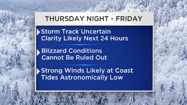
#2) The whole system isn't quite as progressive and it literally explodes in the perfect spot (the sweet spot, 40/70) for New England storms. We feel the full rage of this nor'easter, get blizzard conditions Thursday night into Friday, strong and damaging winds and a boatload of new snow.
Clearly the second option would cause MAJOR problems. With no place to put the snow and wind gusts which could exceed 50-60 mph I cannot even imagine the mess we would have on our hands. The next 24 hours of model runs will be critical in determining the final track, timing and ultimately the significance of this event in southern New England.

We are nearing the breaking point and a storm like this one could potentially hurdle us right over the edge. Please don't take this as "hype", this is a very serious situation. Of course, our team will keep you updated as the forecast becomes more clear.
One thing is certain, this pattern is going nowhere. The snow and cold are here to stay in New England, likely for at least the remainder of February. There is no thaw, no pattern change, no immediate relief in sight. Storm or no storm, later this week some of the coldest air thus far will pour down from Northern Canada. If it isn't snow records, we will likely challenge some low temperature records over the weekend.
Hang in there, stay safe and stay tuned…
Follow Terry on Twitter @TerryWBZ