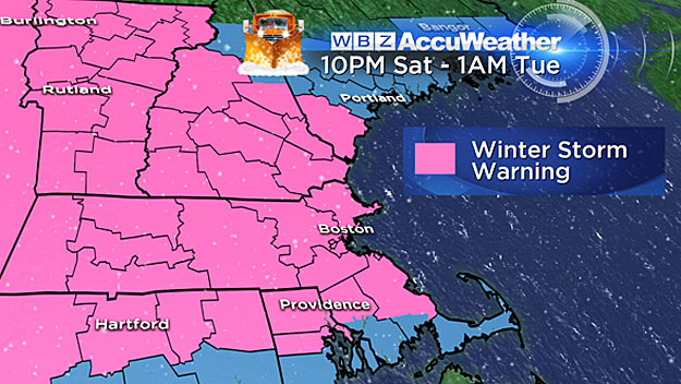
Travel Headaches, School Closings Likely During Four-Day Snowstorm
BOSTON (CBS) – Yes. The snow is still coming.
Perhaps you woke up and logged on hoping to see some breaking news from the weather office reading, "snow called off, significant warm up now expected!"
Not happening.
Check: Weather Blog | Current Conditions | Share Photos
We're about to add to our heaping piles of snow in a major way in the next three to four days.
Get ready for more travel headaches, more cancelled schools and another several rounds of shoveling and snow blowing.
We are in for several days of snow, beginning Saturday afternoon and lasting through early Tuesday.
Watch Barry Burbank's Latest Forecast
Let's break it down day by day, flake by excruciating flake.
Saturday
Let it begin. First flakes will fly by Saturday afternoon. This first impulse of snow is the weakest of the bunch. By Saturday evening there will just be a coating to an inch. Very low impact.
Saturday Night Into Sunday Morning
The snow picks up and our first significant burst of snow arrives. Steady, light to moderate snow arrives around midnight and by 7 a.m. Sunday morning, expect an average of about 1-3" for all of Southern New England.
Sunday 7 a.m.-5 p.m.
Slow and steady, the snow continues. Flakes fall mainly lightly, with most of the accumulation happening north of the Mass Pike. Expect an additional 1-to-3 inches to fall during this timeframe (again mainly north). Storm total accumulations by 5 p.m. Sunday will be 1-to-3 inches south of Mass Pike and 3-to-6 inches north of it.
Sunday Night 5 p.m.- Monday Morning 7 a.m.
The "storm" begins to organize a bit and by Monday morning we will be in the most significant portion of this event. Snowfall will be moderate to heavy at times late Sunday night and Monday morning. Several more inches are expected in this time frame. Storm total accumulations by 7 a.m. Monday will likely be 6-to-10 inches north of the Pike and 3-to-6 inches south of the Pike.
Monday 7 a.m.-5 p.m.
The peak of the storm arrives Monday. I expect another round of school cancellations on Monday and a treacherous morning and evening commute. Many towns will top the foot mark by Monday afternoon. Storm total accumulations by 5 p.m. Monday are expected between 8-to-14 inches from Plymouth to Providence and all points north, 4-to-8 inches from Cape Cod north to Plymouth and 2-to-4 inches on the islands.
Monday Night 5 p.m.-Tuesday Morning 7 a.m.
The final act from this seemingly never-ending snow barrage brings several more inches overnight. Finally by Tuesday morning the snow will begin to taper off and all the accumulation will be done by 7 a.m. Just some lingering light flurries near the coast Tuesday morning.
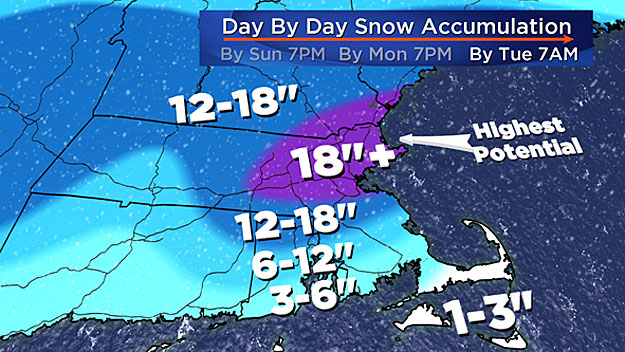
FINAL STORM TOTALS
Expect 10-to-18 inches from Plymouth to Providence and all points north, 5-to-10 inches from Cape Cod north to Plymouth and 2-to-5 inches on the islands.
In the "Jackpot" zone expect the highest snow totals to be just to the north of Boston in parts of Essex and Middlesex Counties due to a coastal front and ocean enhancement. If there is to be a 20 inches total somewhere in this storm (certainly possible) it would most likely be in this zone.
Winds
Not a major concern this time. There will be a persistent east-northeast wind for the duration of the storm, peaking from Sunday night through Monday night. Gusts will top out between 40-to-45 miles per hour at the coast in this time period.
Coastal Concerns
Tides are astronomically low. This is not going to be a coastal flooding event. However, with several days of onshore winds over multiple tide cycles, significant beach erosion in likely.
What's Next
Brutal cold, perhaps record-breaking cold, could roll in late in the week. Thursday night through Sunday looks to be absolutely uninhabitable outdoors. And believe it or not there could be another snowstorm Thursday and/or Friday.
Waving the white flag. Uncle!


