Snow, Ice, Rain In Saturday Night Forecast
BOSTON (CBS) - This has been one of the quietest stretches of weather over the holidays in recent memory. Other than some heavy rain during Christmas Eve, there has essentially been no real weather disruption or complication during any of the hustle and bustle of the last few weeks. Heck, it was nearly 60 degrees on Christmas afternoon, hard to top that. No snow, no ice, no travel concerns.
Download: CBS Boston Weather App
With no weather to be concerned about, I suspect that many folks had checked themselves out of watching the weather report for the last few weeks, one less thing to worry about. Now, as we all emerge from the haze of the holidays, the family gatherings, the food and merriment, it is time to check back in. Right on cue, Mother Nature has a little shot of winter to bring us all back to reality.
Check: Interactive Radar | Weather Blog | Current Conditions | Share Photos
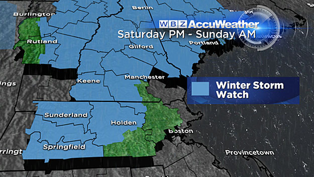
It won't be a major storm, it isn't a nor'easter, but just enough to make for tricky travel and a bit of a mess on Saturday night.
Here is your hour by hour forecast:
Saturday daytime (through 4 p.m.)
Skies will be clouding up, temperatures will be cold, highs only in the upper 20's and low 30's, dry conditions.
4 p.m. - 7 p.m.
Snow begins. First in Connecticut and western Massachusetts, then to Worcester County, and finally to the coastline by 6-to-7 p.m. With temperatures generally below freezing, the snow should be able to stick on roads fairly quickly. There could be a quick inch or two in the first few hours, especially in parts of Worcester County and the Berkshires.
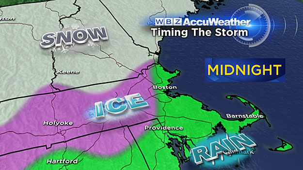
7 p.m. - Midnight
The snow is short lived. Warmer air begins to move in at upper levels of the atmosphere during this timeframe. Snow changes to rain south of the Mass Pike by 9 p.m., washing away any trace of the white stuff. North of the Pike, the cold air right at ground level will be tougher to scour out. So, the transition here will be slower and more gradual from snow to sleet and freezing rain. Areas within 495 and 128 will warm above 32 degrees first and likely be all rain by 9 or 10 p.m. Farther west in parts of western Middlesex County and northern Worcester County, the cold air will initially win out and hold firm. Temperatures will likely hover near or just below 32 through midnight, meaning a real sloppy mess with several inches of snow and a layer of ice on top.
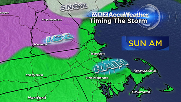
Midnight - 7 a.m. Sunday
Mild air really starts to flow in after midnight. Any remaining pockets of snow and ice in southern New England change over to plain rain. The freezing line lifts well north into central New England. By dawn, it will be all rain and temperatures will continue to rise.
After 7 a.m. Sunday
Periods of showers, a few heavy through midday, becoming more isolated in the afternoon. Very mild with highs in Boston and southeastern Massachusetts likely topping 50 degrees! To the north and west, temperatures minimally will get over 40, perhaps even higher. Needless to say, any snow that fell from Boston and areas south will be long gone. Farther north and west, where higher amounts of snow and ice occurred overnight, the evidence will remain but it will be severely compacted by the rain and turned to slop.
ACCUMULATIONS
So how much snow?
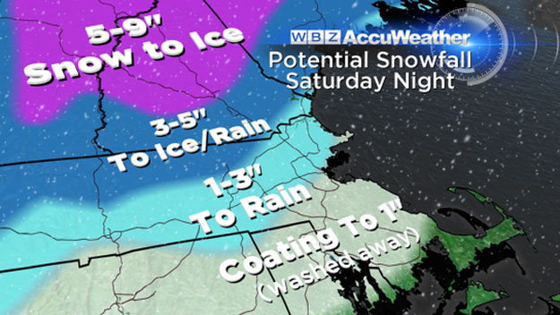
South of the Pike (including Boston):
A quick coating to an inch, washed away quickly, before midnight, by rain.
Nearby suburbs to the north and west of Boston (128-495 area):
One-to-3 inches of snow with a little sleet on top. Most of it gets eaten up by milder temperatures and rain overnight and on Sunday.
Farther north and west, including the Worcester Hills, western Mass, southwest NH:
Three-to-5 inches of snow with a more significant layer of ice on top, likely a plowable situation Saturday night. Again, severely compacted by rain Sunday morning.
Green and White Mountains of VT, NH, ME:
Five-to-10 inches of snow with a crusty, icy layer on top. So it is a good news-bad news storm for the ski areas. They get some much needed natural snow, but it doesn't end well with ice and even some rain during Sunday.
Follow Terry on Twitter @TerryWBZ
MORE LOCAL NEWS FROM CBS BOSTON