Major Winter Storm Threatens Holiday Travel
BOSTON (CBS) - We will squeeze in one more mild day on Tuesday, perhaps even nicking 60 degrees again for the second day in a row, a noteworthy accomplishment for any late November.
Check: Latest Forecast Maps
But that is it. Any dreams of Indian Summer, or a late fall golf outing, are going to down the drain quick.
Check: Interactive Radar | Weather Blog | Current Conditions | Share Photos
A major winter storm is beginning to take shape and it is set to arrive on one of the busiest travel days of the year. This one will affect travel up and down the entire East Coast on Wednesday with heavy rain and wind along the coast in most of the major cities and significant snow in the nearby western suburbs.
TIMELINE
This storm is coming right out of the Gulf of Mexico and riding south to north up the Coast.
The first drops and flakes will arrive in the Washington DC-Baltimore area before dawn on Wednesday.
It will get going in Philadelphia and New York City just after sunrise.
Download: CBS Boston Weather App
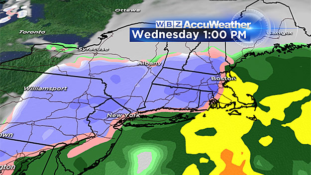
As for southern New England, expect it to start mainly as rain during the mid-to-late morning, say between 9-11 a.m. The rain will change over to snow rapidly in parts of Worcester County and western Massachusetts, within a few hours of the storm's arrival.
Gradually during Wednesday afternoon the change from rain to snow will creep eastward towards the coast, eventually making it all the way down to the Cape Cod Canal well after dark.
The storm will "peak" from late afternoon through about midnight - this is when the majority of snow accumulation will occur along with the strongest winds and highest travel impact.
TRAVEL DELAYS
Likely the biggest story with this event is the poor timing.
There will almost certainly be delays piling up by Wednesday afternoon and evening. I think that during the daylight hours, even as the rain changes to snow, it will initially have a hard time sticking to the roads.
Three days of very mild weather ahead of the storm will heat the surface to a good degree. It will likely be after dark when the snow really begins to stick and accumulate, leaving about a 4-to-6 hour window of real good accumulation from Boston north and west.
After midnight, the precipitation will gradually diminish from west to east and it will be long gone by Thanksgiving morning. The sun will be peeking out by the time the high school football games begin, albeit over a very snowy landscape for most cities and towns.
HOW MUCH SNOW?
The "jackpot" with this event could be twofold.
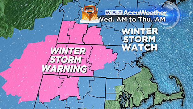
First, where it is snowing for the longest, in Worcester County and points westward.
Second, there will likely be some heavy banding right on the west side of a coastal front (this is a very common feature with nor'easter events in southern New England). With this event this could set up not too far west of Boston, perhaps between routes 128 and 495 or right around the 495 belt.
What is the jackpot with this storm?
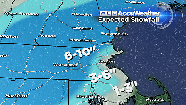
Something on the order of 6-to-10 inches, again in parts of Worcester County and central and western Middlesex County.
To the east, closer to Route 128, the snowfall amounts will begin to drop off quickly and dramatically, from 6-to 3-inches.
Right along the coast and in Boston, all the snow accumulation will happen at the tail end of the storm, likely about 1-to-3 very wet and sloppy inches.
Nothing over Cape Cod and the Islands.
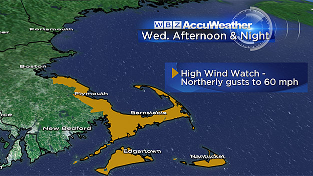
WIND AND COASTAL ISSUES
As you might expect, winds will also be an issue - strong northeast winds at the coast (nor'easter) and somewhat lighter and more northerly winds farther inland.
By Thursday morning, the winds will shift to the northwest and stay gusty.
I am not anticipating a major coastal flooding threat for a few reasons.
First, tides are not that high, astronomically speaking. In addition, this is a quick moving storm, affecting just one high tide cycle, not leaving enough time for seas to build significantly.
The high tide of greatest concern would be around 2 a.m. Thursday.
Follow Terry on Twitter @TerryWBZ
MORE LOCAL NEWS FROM CBS BOSTON