Arctic Front Making Presence Felt!
Find Eric Fisher on Twitter and Facebook
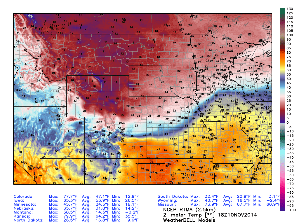
RTMA (Real-time meso-analysis) of temperatures Monday afternoon. Pretty easy to spot the front! Some major temperature extremes on either side. Source: Weatherbell
Storms are exciting, no doubt. The lead-up to a major snowstorm can be stressful but exhilarating stuff for weather fanatics. And a big thunderstorm outbreak? Always captures attention with ease. But for my money, I'll take a really sharp front. Love watching the extremes of nature so close together, with polar air just miles away from a summer-like feel. Then watching temperatures plummet within minutes and changing the entire feel of the world around you. Yeah, that's the good stuff! And that's been on display over the past 24 hours. At one point on Monday, the gradient was in the area of 60ºF over just 160 miles!
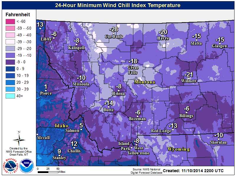
Montana wins the cold award for this outbreak. Wind chills of -10 to -30F are expected, with actual air temperatures in the single digits either side of 0F. Source: NWS Great Falls, MT
This has been a classic arctic front to watch come crashing down out of Canada, complete with a 'mid-winter strong' area of high pressure (around 1050mb!) helping to bring all that frigid air southward. To me, that high has been the most impressive feature. It brought shocking change to the Front Range of the Rockies, which certainly rivals (if not defeats, gasp!) New England when it comes to temperamental weather. Highs in places like Denver, CO reached the low 60s before crashing into the 10s within a couple hours. Many towns saw their thermometer readings drop 30º in an hour or less! Imagine living in the days before forecasting...when you'd be outside and all the sudden get stuck in snow and dangerous cold out of nowhere. At least we can see this coming nowadays.
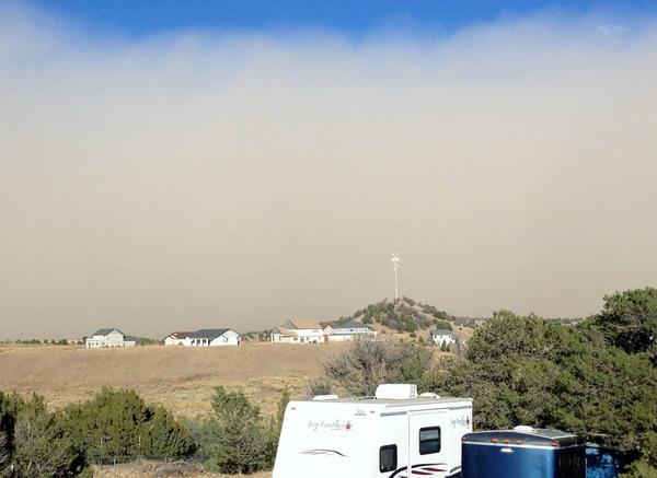
A dust storm roars through Trinidad, Colorado on Monday. Credit: Nancy Carpio
The strong winds (gusting 30-50mph) behind this arctic front helped kick up a wall of dust, producing a haboob as the cold air rushed south. This dust storm picked up in Colorado and roared right on down to Texas and Oklahoma. Good times - get hit with a blast of dirt and the coldest air since last winter right behind it. Must have been delightful.
Now we watch this winter air mass slide eastward over the next few days. It won't move as quickly as it did on Monday, but by Thursday night nearly the entire country, save a few spots in the southwest, will feel more like late December or January. We don't get into the action until Thursday around Southern New England, so the moral of our weather story is to head out and enjoy the moment! Tuesday is definitely our last great chance to go outside to enjoy or finish up some yard work. Wednesday features more clouds and some showers, and then it turns cold for as far down the road as we can see.
Does It Get Cold This Time of Year? Of Course! But....
The interesting thing about this cold air outbreak isn't necessarily tons of record lows being set, but the longevity of it that's expected. All signs point to very long lasting cold with reinforcing shots pouring down out of Canada again and again. So once we go cold, we don't really come out of it. The brunt of this will be felt in the Midwest and possibly the Southeast, where the largest departures from average should live. In fact, the persistent cold may be enough to reach historic levels. We'll have to see where the final numbers end up, but much of the Midwest/Southeast is already running well below average for the month of November, and that's *without* all this cold ahead. The pattern is expected to hold through at least the end of the month.
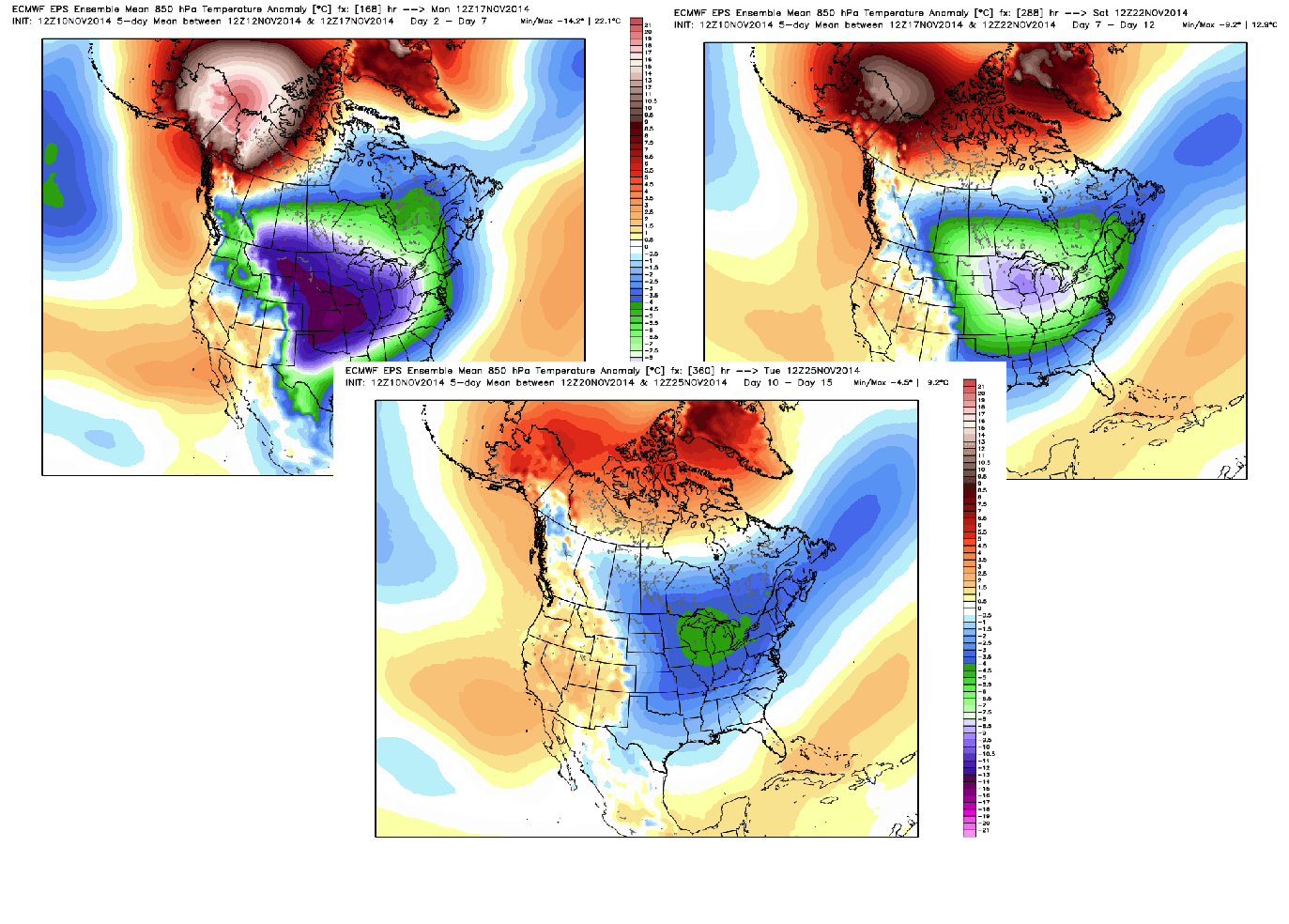
I put together this collection of ECMWF EPS weeklies that came in on Monday. These are ensemble mean 850mb temperature anomalies, which basically translates to 'the departure from average of the air temperature a few thousand feet up over a 5-day chunk of time.' Whether you look at days 2-7, 7-12, or 10-15, the theme stays the same. This cold isn't going anywhere. The Midwest gets in on the most impressive, consistent cold. Source: Weatherbell
Looking back at the books, there are only a couple of years that show up with a similar magnitude of early-season cold. The Novembers of 1976 and 1880 both had numerous cold air outbreaks filtering in across the U.S. So for context, should all the forecasts verify, we're talking about the kind of November cold that's only been seen a couple times in the last 130+ years. At the very least, we should be able to squeeze out some Top 5 coldest Novembers ever recorded in the Midwest.
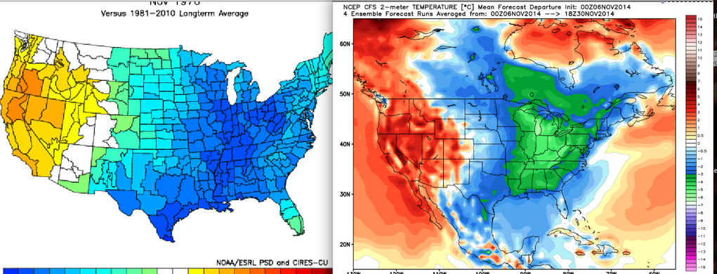
(Left) November of 1976, (Right) forecast through rest of the month. Source: Joe Bastardi
How About Us?
We get to watch everyone else deal with this stuff for a couple more days. The cold air begins filtering in Wednesday night, and should hold Thursday in the low/mid 40s for highs. On Friday, a relatively weak system sliding out to sea may bring us some snowfall. At the moment, it doesn't look like a high impact event. But it's something we should keep an eye on. The weekend may as well be late December, with highs in the 30s and the coldest nights since late last winter (20s). We'll probably nab our first 32º reading in Boston, which would be a week late vs. average. And we'll also have to watch for potential storminess Sunday into Sunday night. Models have been very inconsistent on their handling of this feature, so confidence is low on how it will unfold. But the potential is certainly there for a snow event in some parts of New England; a cold rain elsewhere. Definitely pay attention to forecast updates as we move closer to the weekend. Either way, it'll be cold...and what's on tap for next week? You guessed it, cold! Again probably not record-breaking stuff, but enough to get good use out of your winter gear early and often this year.
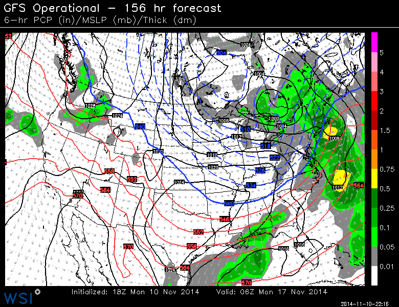
Sunday setup intriguing. Will be cold enough for snow in many areas, if we can get a storm to come close enough to the coast. Solutions range from 'out to sea' to a benchmark low pressure at the moment. Source: WSI Energycast