The '92-93 Connection (Winter Preview?)
Several times in the past few months, I've seen the year 1992 come up. Coincidence? Maybe. But with the DELUGE of interest in the upcoming winter lately (why rush??), I figured I'd give it a deeper look to see if we could find some potentially useful information. And yes, I'm hoping it'll be more accurate than this FAKE article that for whatever reason keeps making the rounds. Know your sources! I know it's hard to believe, but there are people even less trustworthy than Meteorologists out there.
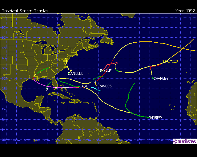
The 1992 Atlantic Hurricane season. Notable for Andrew, but not much else after that. Source: Unisys
The first time I can recall hearing 1992 in a weather discussion, it was in reference to the early stages of the Atlantic Hurricane Season. This year was the only time since 1992 where the first three storms of the season ALL became hurricanes. In 1992, it was Andrew, Bonnie, and Charley. This year, it was Arthur, Bertha, and Cristobal. And like in 1992, both of the 'A' storms made landfall as hurricanes (Andrew being much more notable/infamous than Arthur).
 Tropical Atlantic Satellite Loop
Next up, interestingly enough, is the LACK of activity here at the peak of 2014's hurricane season. Yesterday, September 10th, was the peak of the Atlantic season. You can almost always count on something spinning somewhere in the basin this time of year. The switch is flipped, the water is warm, and shear is low. Not so much this time around. On the 10th, there was no activity in the Atlantic basin other than a couple of 'invest' areas. No hurricanes, no tropical storms, not even a tropical depression. That's the first time there's been no activity on September 10th since, you guessed it, 1992.
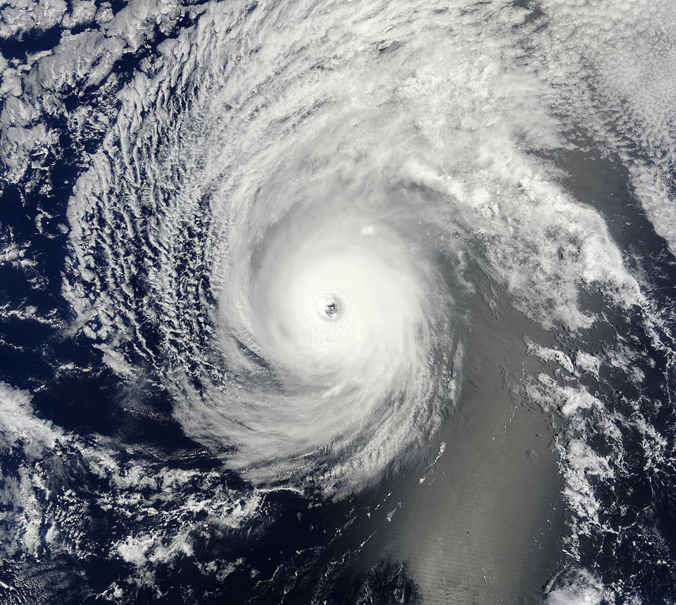
MODIS image of Hurricane Iselle from 3:40 pm EDT August 4, 2014. At the time, Iselle was a Category 4 hurricane with 140 mph winds. Image credit: NASA.
How about even MORE weird tropical trivia? Much was made about Hurricane Iselle's approach to Hawaii back in early August. It was the first time Hurricane Warnings were hoisted for Hawaii since Iniki in...yep....1992. Iselle did weaken to tropical storm status before making landfall on the Big Island on August 8th, 2014.
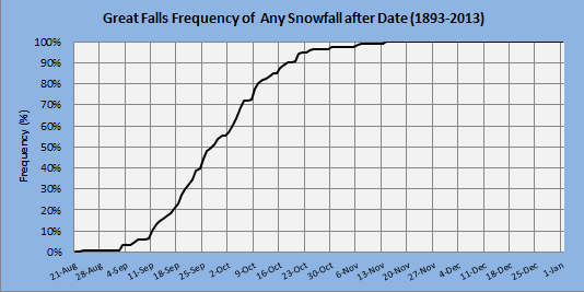
Chances of snow this early, even in parts of Montana, are pretty slim. Source: NWS Great Falls, MT
On the complete other side of the spectrum (and country), early snow is flying in Montana. This after Calgary got absolutely buried over the past couple of days. Sure it's Canada and they're known for being friendly, not having a warm climate. But the average high in Calgary is 65º this time of year and there are still leaves on the trees. This is similar to our 'Snowtober' event back in 2011. And how about Montana? Those lovely high peaks are picking up plenty, but if you think it's early to be talking snow you're right. It was the earliest snow has fallen in Great Falls, MT since 1992! And it was much earlier....falling way back in August that year.
So we've got a few things to go on here. Not exactly an open and shut case, but interesting for sure. So for giggles, let's take a look back at how the winter shaped up after that quiet hurricane season and early cold blasts visited the U.S.
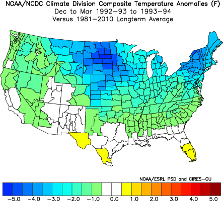
Source: NCDC
Hmmm that looks familiar doesn't it? In fact, it looks a lot like last winter. Bitterly cold air across the Midwest in the winter of 1992-93, and a very cold Northeast to go along with it. The depth of the cold wasn't *quite* as bad as what we saw in 2013-14, but still enough to get Americans grumbling. How about precipitation?
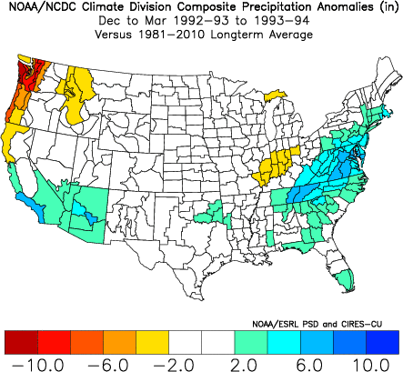
Source: NCDC
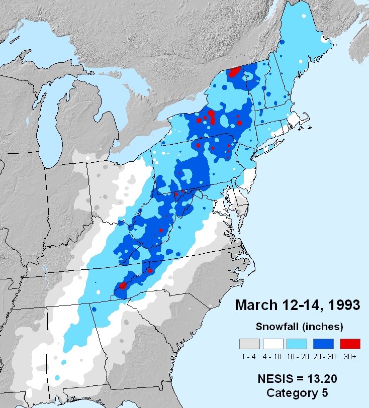
Look at that East Coast! You bet, it was a snowy one. These numbers are slightly skewed, but for a good reason. What happened in March of 1993? The original Superstorm, also known as 'The Storm of The Century.' This was a monster that absolutely buried the East Coast, especially areas near the Appalachians. Destructive and epic, this was the type of storm that many who lived through still remember well. An insane 60" of snow fell on Mt. LaConte, TN! The surface pressured dropped even lower than Hurricane Hugo in parts of the Carolinas (for instance, Charlotte and Columbia). Over 100 people were killed, over 10 million customers lost power, and at one point every major airport on the East Coast was shut down. So yeah, that helped raise the snow totals a bit.
Source: NOAA
So can we say, with any sort of confidence, that we'll repeat with a cold winter and a blockbuster storm or two? Well there are certainly limitations in long-range forecasting. If it was easy, people would be making millions of dollars making commodity bets with their forecasts. Trust the Farmer's Almanac? Sorry, but they'd be doing the same thing if they could actually get it right every year (this summer was supposed to be a scorcher across the U.S. - whoops!). So no, I can't tell you beyond a shadow of a doubt what's going to happen this winter.
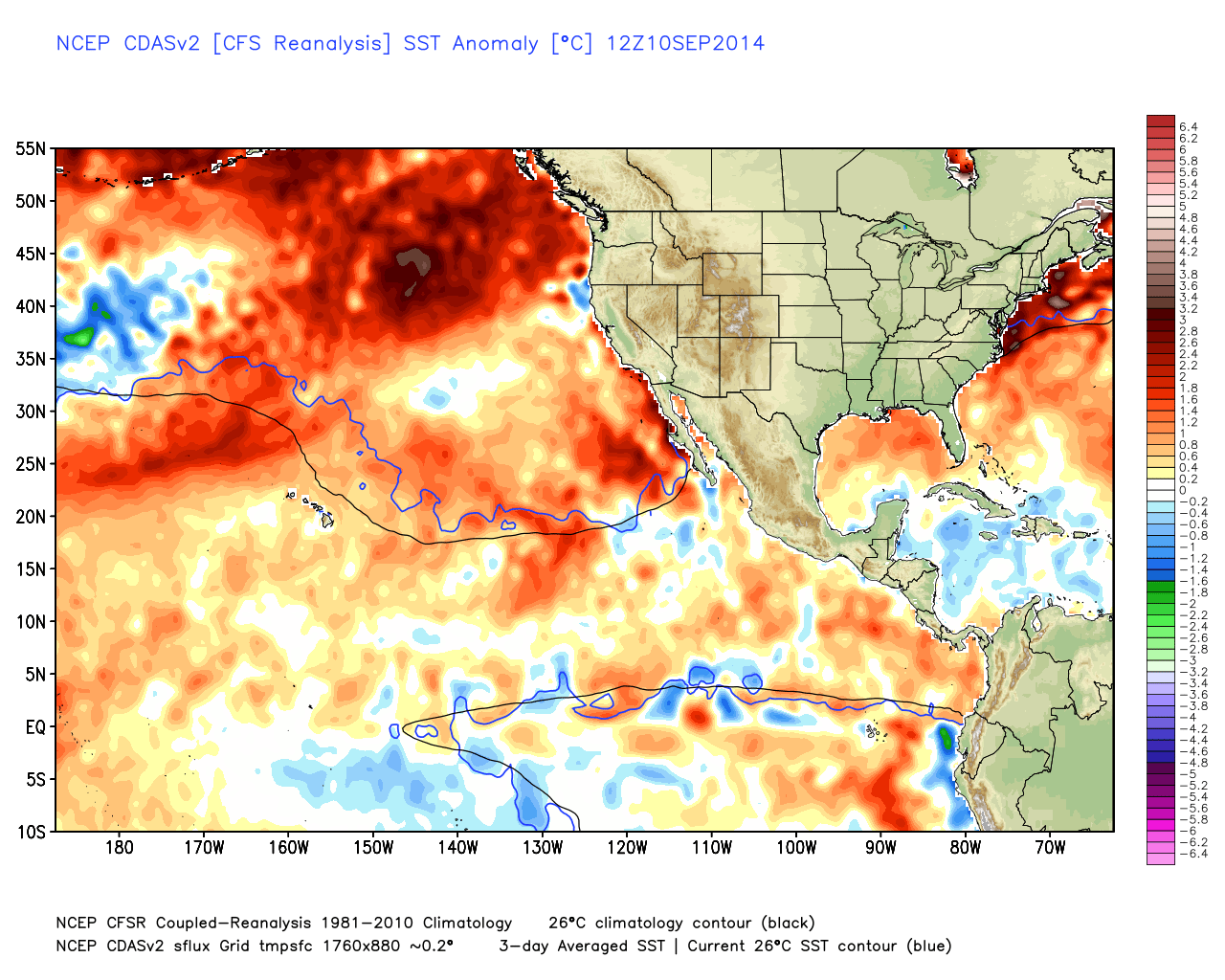
Current Sea-surface temperature anomalies. Notice the huge area of well-above average water off the NW coast. Source: WeatherBell
What we can do is look for signals (sea ice, ocean phases, etc) and make educated predictions. One thing that's still in place from last winter is a pool of very warm water in the northern Pacific (when you hear about the PDO - Pacific Decadal Oscillation - this is what we're talking about). As the name suggests, these patterns can last a long time and can greatly influence the jet stream circulation around the globe.
This pool of warm water should help build a strong ridge over either the West Coast or Alaska heading into this winter (a +PNA, or Pacific North American Pattern). Exactly where this semi-permanent ridging develops will be key as to who gets the coldest winter. If it forms right along the West Coast - expect a dry and warm winter there with big cold pushes coming down into the Midwest and Northeast. If it sets up farther west and toward the Gulf of Alaska, those cold blasts may be far harsher to our west than here locally.

Source: NOAA/ESRL
There have been a lot of questions about El Nino coming in as well. NOAA is still predicting a slightly better than 50/50 shot of a weak/moderate El Nino late this fall and winter. Looking at the region in question, water temperatures are almost identical in the equatorial Pacific right now as they were at this time in 1992. We had a weak El Nino in the winter of 92/93...barely above average water. There are very few who think a major event is coming, and we should stay with above average water. So all things told, conditions there are very similar to the 1992/93 winter.
One other thing we can say about winter is that it's tough to get a REALLY cold winter AND and REALLY snowy winter. Typically, if it's going to be frigid here in New England, the reason is because of strong Arctic highs that blast down from Canada and keep us in a bitter north-northwest flow. Those same strong highs (often over 1040mb in the winter) can keep the storm track suppressed to our south and east, with the big ones developing out to sea. So a colder than average winter doesn't really load the dice in favor of a snowy winter. There have been years with numerous big storms that actually ended up above average (when your average highs are in the mid 30s anyway, it doesn't really matter if it's much colder...there's plenty to work with).
So we'll see where all this goes in a couple months. In the meantime - enjoy the fall! I don't see any major cold outbreaks heading our way through September, so there's no rushing the raging furnaces and penguin walks to the bus stop. Hopefully we'll get in a nice long stretch of pleasant weather before whatever decides to head our way arrives.


