A Better Looking Weekend Forecast!
Find Eric Fisher on Twitter and Facebook
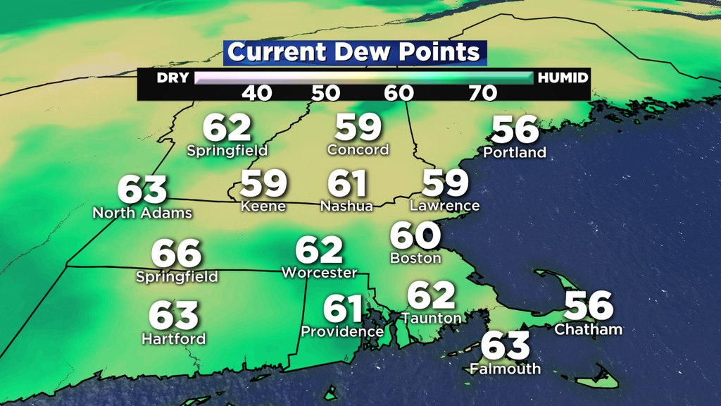
May is a month when the feel of summer visits from time to time, and the humidity that's taken up residence is a reminder of that! There's a huge plume of moisture that extends down to the tropical Pacific, and that's been channeled up the East Coast. Ahead of the front collecting and focusing all that moisture is deep southerly flow, bringing low 60s dew points into southern New England. Bottom line - bad hair day season is here.
Friday looks much like today, but with a few slight changes. There should be a little more cloud cover, a little more wind, and a slightly higher chance of showers during the afternoon/evening. Highs again will top out in the upper 60s to mid 70s, with a very sticky feel to the air. Some southeasterly wind gusts could top out around 30mph, particularly near the coastline. As for the rain, the highest chance of showers is across Western Mass, and will move into Worcester County during the afternoon/evening. There's just a slight chance of showers farther east. I don't think it'll be enough to cancel any afternoon/evening baseball games or outdoor events, but have rain gear handy just in case some showers pop wherever you are.
 Water Vapor Loop
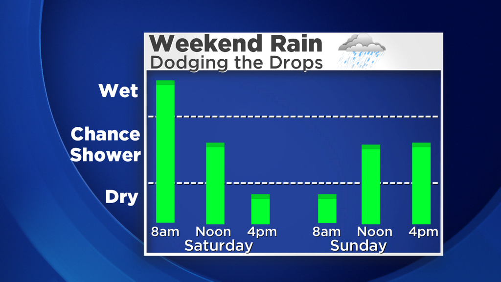
As this whole system plods along, it will finally bring a high likelihood of showers by the overnight across the whole area, and then drag a band of steadier, heavier rain through late in the overnight and into Saturday morning. This should end up being a very thin, slow-moving band of rain that dumps 1-2.5" of rain across WMass but lesser totals for towns to the east. I'm thinking as little as .25" for the Cape, with the upper end of the range closer to 1" in the Worcester area. Boston should be close to 0.5" for the event. So not enough to cause any major issues, but it should be enough to water the lawn and any fertilizer you may put down.
Here's the good news - the timing of this front looks a little faster, and it should move this band off rain offshore by midday. As we head into the afternoon skies should brighten up from west to east, and temperatures will hop up into the 70s. A very salvageable Saturday! So the best bet for now looks to be a slow morning around the house, before the sunshine returns. Now that we're into graduation/wedding/bbq season, I'm sure this will make more than a few people happy.
Sunday is looking a little less gloomy, too. The morning is expected to be the best time to be outdoors. As we head toward noon and beyond, clouds should fill in quite a bit and there will be some scattered showers around. Not expecting widespread rain, and not expecting a washout. Just some drops to dodge during an unsettled 11a-7p time frame. Highs should manage the 60s to near 70.
You want a little more good news? Your TGIF sunset is at 8:00pm, and sunsets will stay at 8pm or later all the way through August 4th. That's 12 weekends of grilling, spending time at the beach, or taking in a baseball game with beautiful late day sun lending a helping hand. These long days don't hang around for too long, so soak them in while we can!
A cold pool of air aloft should rotate in for Monday and Tuesday, which produces instability and a high chance of showers/storms. Not expecting severe weather, but some hail storms and gusty winds could be a result in any storms that do develop. Highs should stay a little below average for this time of year, in the lower 60s.