Final News & Notes on A Record Cold March
Find Eric Fisher on Twitter and Facebook
The final numbers are in from various National Weather Service offices, etc on March, and the news won't come as too much of a shock. It was cold out. Almost all month long. And if you think it was bad here, it was actually even worse just a stretch to our north and west. Let's take a peek at some of the specifics and then we can put this baby to bed and head onward to spring.
New England:
Cold yes, but unusually so. In fact, many New England cities endured their coldest March ever recorded! Caribou, Bangor (tie), Montpelier, Mount Mansfield, and Rutland all ended up in the top spot. Just over the border into New York, Massena also saw its coldest March ever recorded. Not far behind were Portland, Burlington, and right here in Worcester. Those three cities saw their 4th coldest March since records began. Boston was a laggard - it was the 19th coldest in the Hub. However, I always take Boston cold records with a grain of salt. There's a substantial Urban Heat Island effect, the station is now on the water (it used to be downtown back in the day), and it tends to be a poor representation of the area (even for places as nearby as Newton and Belmont, etc). It would be interesting to take out the first 30 years of records or so and see where we'd stand with this year's numbers. Below is a breakdown of a few of these cities.
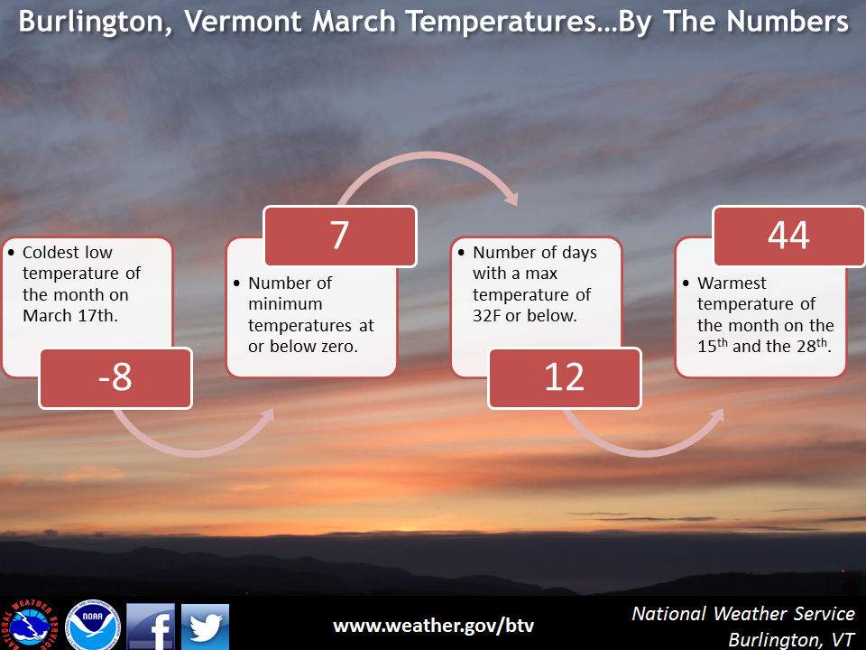
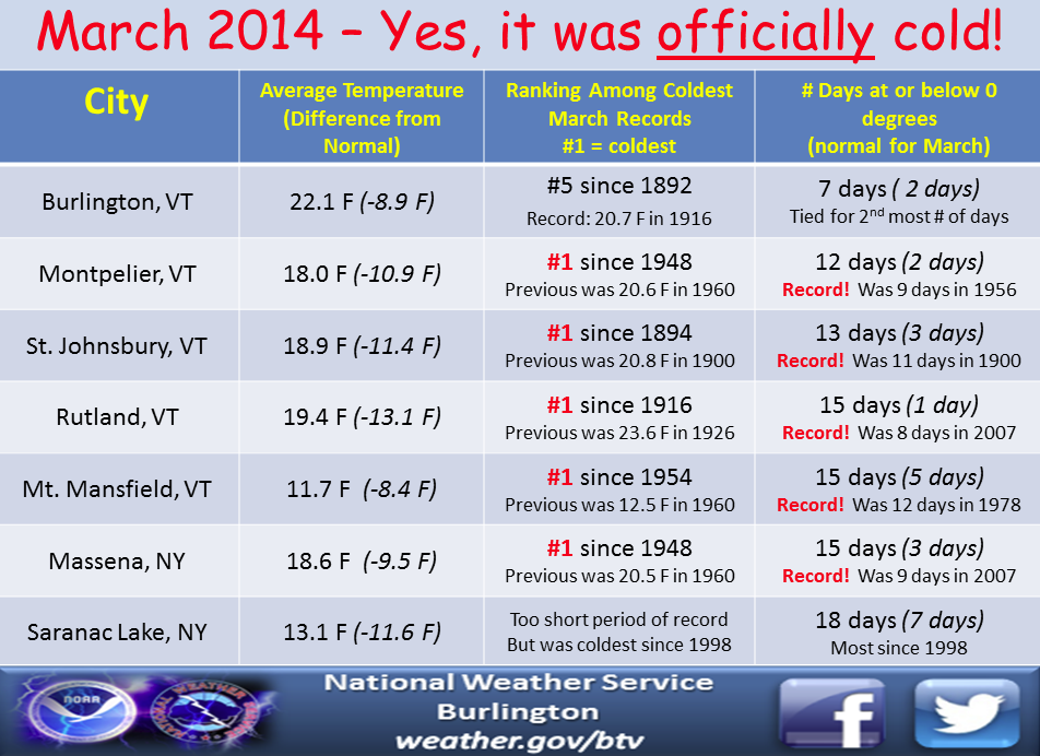
Burlington, VT (records date to 1892)
Average temp: 22.1F. This was 8.9F below average. The all-time record is 20.7F set in 1916. Burlington also saw 7 days at or below zero, which was the 2nd most on record.
Massena, NY (records date to 1948)
Average temp: 18.6F, which was 9.5F below average. Massena saw 15 days at or below zero, the most ever recorded for March. 6 daily record lows were set.
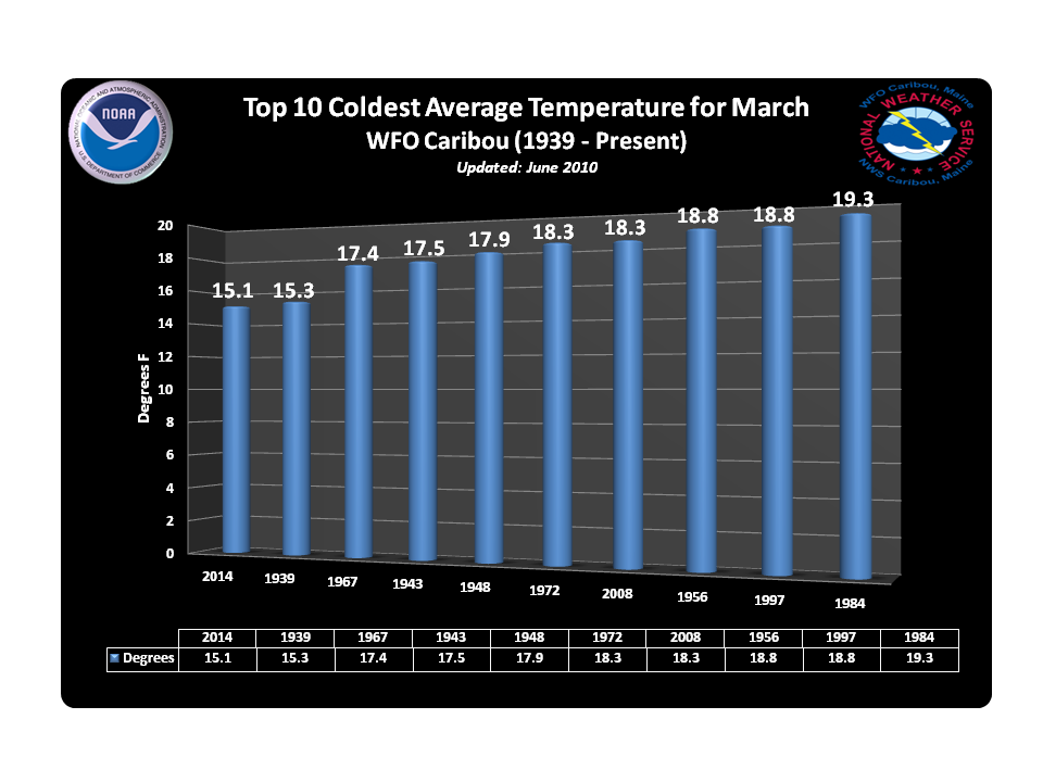
Caribou, ME (records date to 1939)
Average temp: 15.1F, which was 9.4F below average. There were 14 nights at or below zero, tied for the most ever recorded (1939). It was also the 3rd snowiest March on record with 42.1". Only 2008 and 1955 featured more snow.
Mt. Mansfield still has an impressive 70"+ of snow on the summit, after reaching its peak of 87" on March 22nd/23rd (typical time of max snow depth there). The mountaintops aren't the only place still buried in the white stuff. The snow pack is most impressive where you might expect it - Maine. They don't call 'em Mainiacs for no reason. Parts of the state still have a whopping 50" of snow on the ground!! Needless to say it will be quite some time before all that melts. With no major rapid warm-ups on the horizon the melt this year should be gradual and orderly, unless something changes dramatically in the next couple of weeks. A slow warm-up would also be good for maple syrup producers - hopefully they can salvage their season if nights are still chilly and days don't see significantly high temperatures.

The Midwest
Chicago takes the cake for absolutely brutal weather. It was just a couple years ago when people were heading to the BEACH along Lake Michigan in March as record highs were falling like dominoes. Not so much this time around. While the actual depth of the cold in March wasn't that bad (19th coldest on record) it was enough to produce a much more impressive record. The period of December 2013 through March 2014 was the coldest such 4-month period ever recorded in Chicago, with records dating back to 1872! Below are the standings to include previously notorious years, from the National Weather Service Office in Chicago.
RANK AVERAGE YEAR
DEC-MAR TEMP
--------------------------------------------------
1. 22.0 2013-14
2. 22.3 1903-04
3. 22.5 1977-78
22.5 1892-93
5. 22.7 1978-79
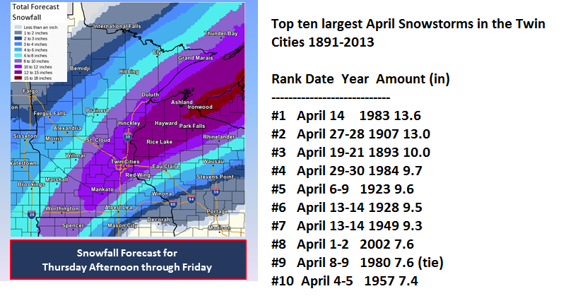
The snow is still very deep across the Upper Midwest - as much as 3' still on the ground across northern Minnesota. And it keeps on coming. Over the course of Thursday/Friday another foot of snow is expected for these same areas. Snow melt alone is not expected to be enough to cause Mississippi River flooding downstream, but may cause local flooding when it finally does melt. If Minneapolis can get into the double-digits from this next snowstorm, it would be one of the Top 3 biggest April snowstorms ever recorded in the city. Yet another superlative!

Source: NOAA and the NOHRSC
The Arctic
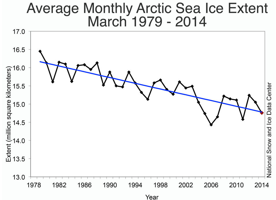
Source: NSIDC
One last newsworthy item came in today on the winter that we hope is finished. According to National Snow and Ice Data Center, the maximum Arctic sea ice extent was reached on March 21st. The extent of that ice wasn't very impressive, at a paltry 5.76 million square miles. Here's an excerpt on the season from the NSIDC:
"Overall the 2014 Arctic maximum was the fifth lowest in the 1978 to 2014 record. Antarctic sea ice reached its annual minimum on February 23, and was the fourth highest Antarctic minimum in the satellite record. While this continues a strong pattern of greater-than-average sea ice extent in Antarctica for the past two years, Antarctic sea ice remains more variable year-to-year than the Arctic."
You may be asking - how is that possible...it was so cold out! We get these types of questions a lot. The point we always stress is that whatever is happening on our tiny, postage stamp size of the planet is rarely indicative of what's going on globally. The global picture is what matters when trying to find trends and changes to our planet. So just because it was very cold here, doesn't mean the whole world was shivering.
In the Arctic temperatures well well above average all winter. Now that doesn't mean it was warm - it's the Arctic. 'Above average' is still absolutely frigid. But with continually dumping cold air southward and emptying out the pole instead of a tight and intense polar vortex caging it in more frequently - these anomalies were able to take place.
At the same time, Antarctic ice coverage is still near all-time record highs. The South Pole has had no shortage of ice, and sat at its 4th highest minimum this season (it's summer there). For several years now the Antarctic has kept high concentrations of ice, while the Arctic quickly dwindles.
As a whole the planet is actually warmer than average. You can see that some of the largest departures from average are across the far northern latitudes, and that the U.S. & Canada stick out like a sore, frozen thumb. You could search the globe and be hard pressed to find a place more farther away from the typical norms during the first 3 months of the year!

Source: WeatherBell