Say Goodbye To The March Rain Deficit
Find Eric Fisher on Twitter and Facebook
The 60º threshold has been a tough one to break lately. We've had a few breaks from the cold each of the past few months, but we haven't broken the barrier since November 27th! Today spiked to 60º on the dot in Boston (no one else reached that high), but no further. Beggars can't be choosers - it felt great! Actually threw open all the windows and let some fresh air flow through the apartment...always a good feeling this time of year. Even the showers that came through had a spring feel, and some people wrote in to say they heard 'peepers' (frogs) for the first time. To cap it all off, a few rainbows spotted. Yes folks, spring is here. It's a bumpy ride, but has some great moments.
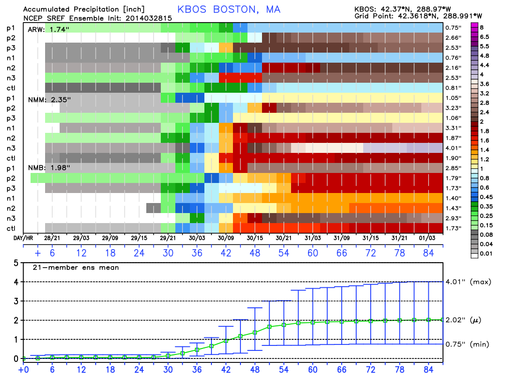
Rain is a right of passage in the springtime too, and there's plenty of that on the way this weekend. In fact - it's a good thing. Boston is running -2.97" behind in the precipitation department for March. All that cold air in a constant NW flow has kept many a storm off our coastline for the past several weeks. We'll make up that deficit in a hurry. Above is the SREF output for rain this weekend. The mean is around 2", and I'm thinking a widespread 1-3" is looking likely from Saturday afternoon through Monday. So when the page is flipped to April, the records will just show 'average' for March.
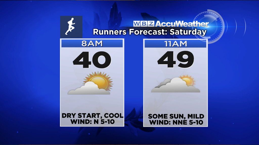
The weekend is NOT a washout though. You'll have ample time to get out and enjoy the outdoors on Saturday morning/midday before this soaker moves north. We should wake up to the upper 30s/low 40s, and warm up into the 50s for many towns by early afternoon. It's a big weekend for marathon runners...typically the last LONG run on the training road. Many will attempt their 20-22 mile training run, and as a runner myself I have to say the recent stretch of Saturdays has been fantastic. It seems like every Saturday for the past month has been the best day of the week! Once again, the weather cooperates. Good luck to all!
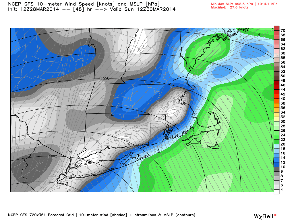
As the day wears on, we'll eye the front that brought showers as a cold front Friday evening. It will stall off to our south in the morning, and then return as a warm front Saturday afternoon. Steady rain should move in around 1pm for the South Coast and Islands, and move its way northward through the afternoon. By dinnertime, the whole area should be seeing a steady rainfall.
Downpours and the heaviest of rain from this storm should come down Saturday night into Sunday morning. A pretty decent bit of instability should enter at least SE Mass, and add in some thunder/lightning to the mix. As the day wears on on Sunday, the rain should get a little more spotty in nature but still expecting gray skies, cool temperatures, and a raw feel to the air. The Eastern States 20 miler does not look like much fun, unless you are extremely hardy stock. 30s & bouts of heavy rain may make this year's running a pretty difficult one to power through.
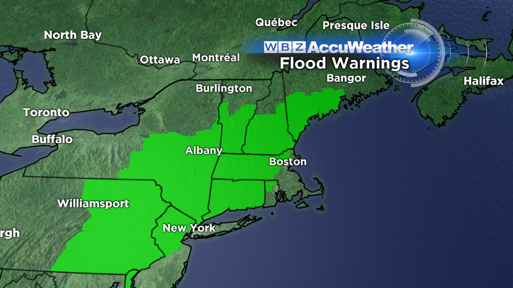
Flood Watches have been posted for much of the region, due to the combo of rain and snowmelt. The ground is still at least semi-frozen in many areas, which means the tendency will be for rain to runoff more than soak into the ground. Plus, there's no plant life that's alive and helping to absorb the rain yet. 1-3" of rain looks like a great bet, and it's not out of the question some towns could see up to 4" of rain. I think that 1-3" of rain will not be enough to cause more than minor issues (like urban street flooding, poor drainage flooding, areas of standing water). It's been very dry and stream flows are low. But it's a situation we'll have to keep an eye on.
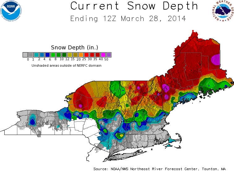
Looking at the latest update to NE snow depth, you can see that we have made some progress in melting away all of this winter's snow. However, there's still a decent amount on the ground across much of Worcester County, the Berkshires, northern Middlesex, and certainly northward into NH/VT/ME. That snow will absorb some of the rain, and the good news for these areas is that we're not combining rain with warm temperatures. Most of the towns with significant snow on the ground will stay in the 30s/40s this weekend. That's a better situation to be in than a day or two of 60+ temps AND rain. By the middle of next week, there shouldn't be too much snow left on the ground here in MA. Will be nice to start seeing the lawn again!
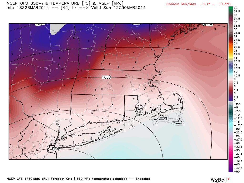
Sunday's temps look very tricky. Above is a look at winds near the surface Sunday morning, plus temperatures at 850mb at the same time. You can see how the areas NW of Boston are already in northeasterly winds, while southeasterlies are keeping milder air in place across SE Mass. They meet in the middle, and that's where heavy rain will likely be ongoing. As the day wears on and the storm moves a little farther east, the northeast winds will win the battle. The ocean is extremely cold right now, and that will force everyone to plummet down into the 30s by the afternoon/evening. That chilly air will be very shallow....I included the 850mb temps to show how a strong 'inversion' will be in place. Basically, the air right above the surface will be much warmer. If we had sunshine and a westerly wind instead of an onshore wind with the same 850mb temps, it'd be in the 70s! Ah well, such is spring around here. For the moment I'm going to lean toward the colder forecast, but stay tuned for any changes that may be necessary.
The storm continues to sit and spin on Monday, a drifting 'stacked low' near the coast. There won't be any strong jet stream winds nearby to push it along, so we'll be stuck with another ugly day of weather for the final day of March. Rather fitting if you ask me. The onshore flow will keep temps in the 30s, and scattered areas of rain, snow, and sleet will rotate around the low. Yes, snow. The column of air should continue to cool to the point where flakes and sleet pellets will start mixing in, especially from Boston north and west. Not expecting any major accumulation, but it shows you how chilly the day will be.
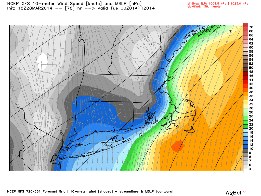
Of main concern on Monday/Tuesday will be the building seas. This onshore flow begins on Sunday afternoon and continues into Tuesday morning. Without much change in the NNE wind direction, each successive tide cycle should come up a little higher. Monday night's will likely end up being the highest, and astronomical tides will be running high in tandem with the storm. So at least minor coastal flooding looks like a real possibility, and may reach moderate flooding if the storm sets up in just the right spot.
The consistent wind direction and rough seas may also pose an erosion concern. Cape Ann to Plum Island, the South Shore, and the eastern flanks of Cape Cod/Nantucket will be most at risk for this. Hopefully it doesn't escalate to anything major, but people living on the coast should be advised that sifting sand is in play for this time frame. Again, the exact placement on strength of the low will be a key player in how this unfolds.
By Tuesday the system will finally depart, and drier air will slowly move in. Tuesday and Wednesday, perhaps into Thursday, look to be the best part of next week with a break from storms and more seasonable temperatures. It doesn't look like we'll be skyrocketing into warmth or anything like that, but at least no 30s!! The Sox home opener at Fenway is scheduled for Friday and early indications are for showers/chilly temps...but nothing to get worried about 7 days out. We'll hope for a pattern change before the boys of summer return home to claim their rings!