SE Mass, Cape And Islands To Get Worst Of Wednesday Snow Storm
BOSTON (CBS) -- Yup, it's still coming - our late season winter storm is on the way and will make for a messy Wednesday morning in southeast Massachusetts.
Check: Current Conditions | Interactive Radar | WBZ Weather Blog
This storm is going to be an absolute beast by Wednesday morning. It will look a lot like a summer-time hurricane a few hundred miles off our coastline, perhaps even having a signature "eye" on satellite imagery. Winds near the center of this storm will likely reach hurricane force, greater than 75mph. Thankfully, this will all be happening well offshore and over the open ocean, but tropical storm force winds will extend several hundred miles out, enveloping much of Eastern Massachusetts.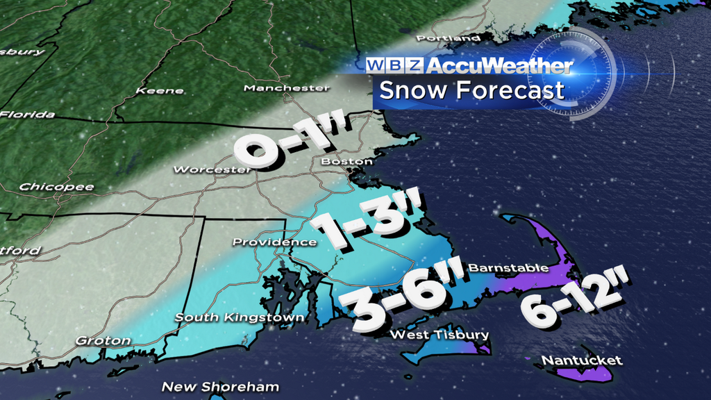
Let's get right to it - here is what you should expect, inch-by-inch, hour-by-hour:
Through Midnight Tuesday: Thickening clouds, but no significant weather. Just before midnight there may be some light snow developing along the South Coast.
Midnight-5AM: The onset of the snow looks a tad later than it did yesterday. The steady shield of snow should come onshore along the South Coast around 2am and reach Boston by about 4-5am. I wouldn't expect more than about an inch or two along the South Coast, Cape and Islands by 5am and just coatings elsewhere.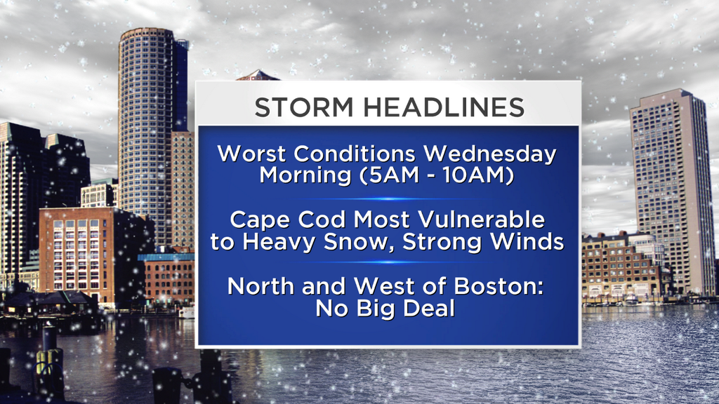
5AM-10AM: The "peak" of the storm - this is when the heaviest snow shield will push into southeastern Massachusetts and the storm will make its closest pass. Whiteout conditions are likely at times over Cape Cod and the Islands with heavy snow and winds gusting 50mph or higher. Snowfall rates of an inch per hour or greater are likely over the Cape and steady, accumulating snow will extend into extreme southeast Mass. From Boston and to the north and west, this will largely be a non-event…just some light snow or flurries, but no significant travel worries.
10AM-2PM: This is a fast-moving storm system and it will already be pulling away and headed for Nova Scotia during this time frame. The back edge of accumulating snowfall will be moving from west to east and the snow will taper off in most locations by midday. The snow will continue over Cape Cod through 2pm, but it will become lighter in intensity by 2pm.
2PM-5PM: The center of the storm will flying off to the northeast, pulling any last snow bands off of the Cape, ending our snow. Winds will slacken off and gusts will lessen. Cleanup time.
So how much?
Outer Cape Cod and the Islands: 6-12"
Extreme Southeast MA, (Plymouth) to Upper Cape: 3-6"
Boston area, immediate Southern Suburbs: Just a dusting to an inch at worst, no big deal.
North and West of Boston (Middlesex, Essex, Worcester Counties, Southern NH): a non-event, just some flurries possible
Again the biggest story with this storm will likely be the wind. 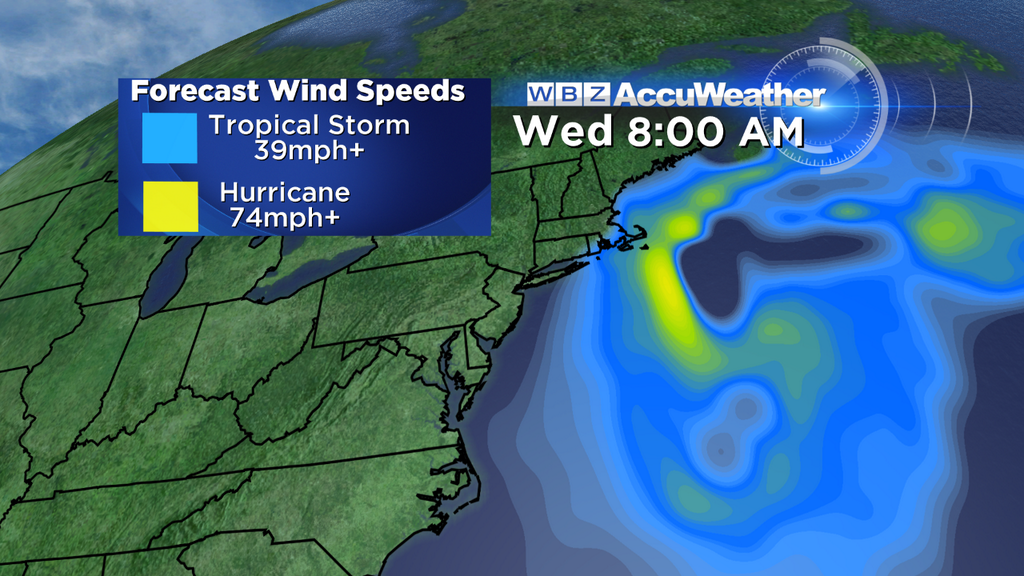
Here are some ranges for peak wind gusts on Wednesday Morning:
Outer Cape, Nantucket: 30-60mph with some isolated gusts to 70.
Upper-Mid Cape: 30-50mph+
East Coast and southeastern Massachusetts: 25-50mph
Rest of the area (inland) 20-40mph
Hang in there, once we get past this one, a pattern change appears to be on the way...50+ Friday and Saturday means most of the snow will be long gone and long forgotten by the end of the weekend. And again, there is a good chance that this storm will be our last significant winter event of the season!
Follow Terry on Twitter @TerryWBZ
MORE LOCAL NEWS FROM CBS BOSTON