Midweek Storm Mostly Rain For Southern New England
BOSTON (CBS) --- It appears that we might be finally ready to turn the corner. The storms are still coming but it is becoming harder and harder to produce snow in southern New England.
Check: Current Conditions | Interactive Radar | WBZ Weather Blog
Winter is trying to hang on, but the strong, March sun is fighting back. To get a pure snowstorm here at this point, you need several factors to line up just right and that will not be the case with our upcoming storm. Sure feels good to deliver some good news once in a while!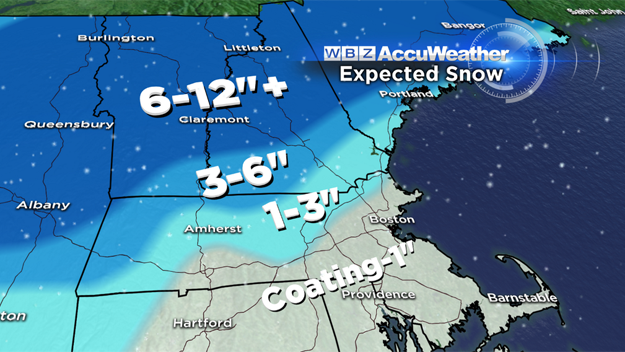
So here's the deal with the Wednesday/Thursday storm:
Some light rain or snow showers are possible as early as Wednesday morning north of the Massachusetts Turnpike. However, the initial batch of precipitation will largely be located north of Manchester, New Hampshire and will fall as snow.
It will take until mid-to-late afternoon for southern New England to get into the action and it will arrive as rain. Between 5 and 11 p.m. the rain will come down fairly heavy at times, likely causing some localized street flooding. Some locations may receive an inch or more of rain Wednesday evening.
After 11 p.m., the cold air from the north will start to seep southward. The rain will gradually begin to mix with and change to snow between midnight and 2 a.m. in the Worcester area and between 3 and 5 a.m. in Boston. By this time, the heaviest precipitation will be over, however there will be some pockets of moderate snowfall by dawn and during the morning commute.
Also of concern is a flash freeze as temperatures will drop fairly rapidly overnight and dip below freezing everywhere by morning. So many of the puddles from Wednesday night will freeze up and then get a fresh coating of snow on top.
By late morning Thursday, the snow will break up and become more spotty.
Any snow accumulation should be done by midday on Thursday, but the winds will continue to howl, ushering in very cold air. Highs on Thursday afternoon will be in the 20's and windchill values will be near zero at times, a stark contract from the 50's today!
So how much snow?
Just a coating to an inch in the Boston area and nearby suburbs, including all of southeastern Massachusetts during Thursday morning.
From Worcester to I-495 north, including Marlboro, Lowell and Lawrence up to Nashua, NH and down Route 2 to Fitchburg: about 1-to-3 inches.
Extreme northern Worcester County, the Monadnock region, western Mass. (elevation): 3-to-6 inches.
The "jackpot" from this storm will be up in central and northern New England (most of the ski areas): a widespread 6-to-12 inches with pockets of up to 18 or 20 inches of snow!
Looking ahead, no big storms on the horizon after this one departs.
Temperatures will be seasonally cold, mainly in the upper 30s through the weekend with one milder day, Saturday (near 50).
You can follow Terry on Twitter @TerryWBZ
MORE LOCAL NEWS FROM CBS BOSTON