Weekend 'Warmth' and Next Week's Uncertainty
Find Eric Fisher on Twitter and Facebook
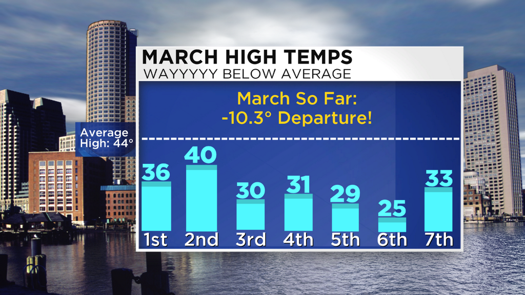
It's all relative. That sums up the general feel of weather around here lately (and truly, all the time). Our memories are short, our senses recalling just recent times, and so when we hit the 30s today it felt like time to head to the Esplanade for 4th of July fireworks. And that delightful high in the low 30s? About 10 degrees below average! Just speaks to the depth of the cold we've had to start March. Every single day this week saw below average temperatures, with Boston running 10.3º below average and Worcester running a whopping 13º below average through 7 days. Looking forward, I only see a day or two in the next 10 that could go above average (and barely at that), so we could be on our way to some record territory if this sort of pattern keeps up.

A storm that brought so much ice to parts of North Carolina as to have their Governor declare a 'State of Emergency' again (in March!!) is rolling along to our south. Dry air over New England and an approaching cold front will help keep this storm at bay, bringing just some clouds to SE Mass overnight and perhaps a few rain showers for Nantucket and the Outer Cape. For a brief time, it may be *just* cold enough to bring some light freezing drizzle to parts of the Cape, but that probability looks fairly low. This low will head out to sea tomorrow morning; nice timing for the Cape Cod St. Patrick's Parade!
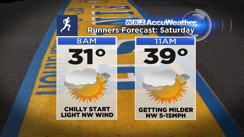
A great Saturday for those hitting the pavement and setting out on long Boston Marathon training runs. Best of luck!
We'll live in a small window of nice weather on Saturday, helping temps jump into the 40s across the area. A cold front swinging through will usher in cooler air aloft and cap our temps in the 40s, with just an outside shot of a few 50s in SE Mass before that air arrives. The higher elevations may stay in the upper 30s to low 40s, so don't expect a ton of melting snow with this brief break (especially considering how cold our snow pack is right now).
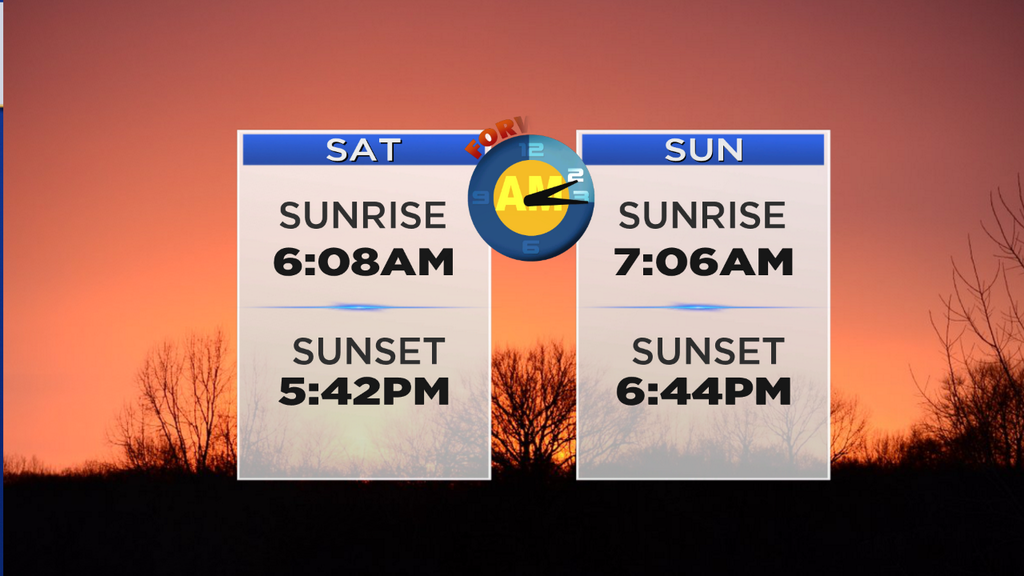
A quick flurry or sprinkle is possible Saturday night, but the main headline is that Daylight Saving Time will begin! 'Spring Forward' and set your clocks ahead 1 hour before going to sleep. Yes, it potentially means less sleep. But you'll be happy with that nice late sunset Sunday night! As for the weather, cool and breezy but not too bad. Mostly sunny skies and highs in the 30s to near 40 are pretty seasonable for this time of year. Another good day to hit the slopes or snowmobile trails!
Very quickly on Sunday night a clipper will glide through, bringing areas of snow showers through Monday morning. There could be some minor accumulation with this one, but doesn't look like anything big. Just a reminder that winter is still in charge. We should manage a milder day on Tuesday, although there are some discrepancies on where a boundary will set up on Tuesday and how much sun we'll actually see. It's this time frame where a lot of question marks arise in our forecast.
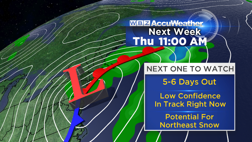
So there's been some chatter about a potential storm, and yes certainly all the models are pointing to one developing during the middle of next week. But at this time frame (which is pretty typical) there is still a ton of uncertainty as to how this will pan out. The solutions range from mainly rain and some mix, to significant snow, to a glancing blow, to missing us to the south. Needless to say, I wouldn't go canceling plans at this point.
The operational ECMWF has been most bullish, producing a phased and powerful low pressure center, taking a track close to or along the coast. It's also much slower, bringing a long-duration bucket of slop to the region and monster snow in parts of the Northeast. This probably falls under a 'worst case scenario' label, and the ECMWF has not had a good track record in the Northeast dating back to last fall.
The operational GFS features a faster moving system that's mainly northern-stream jet energy. The trough associated with it gets to neutral, but doesn't go strikingly negative. The track of the low itself is farther south, and would be a good track for snowfall here in southern New England. There are also several ensemble members that completely miss us to the south, which is a possibility.
Below is a comparison of the 2 operational models (for those wondering, the Canadian GEM has a track even farther west, with a much milder solution for us here locally). These depict the same time (8am Thursday) and you can see how much they differ. The GFS low center is hundreds of miles farther east at this point, with us firmly in the cold (snowy) air from the event. The ECMWF features a low over Atlantic City, NJ and still slowly plodding NNE.
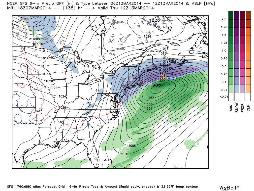
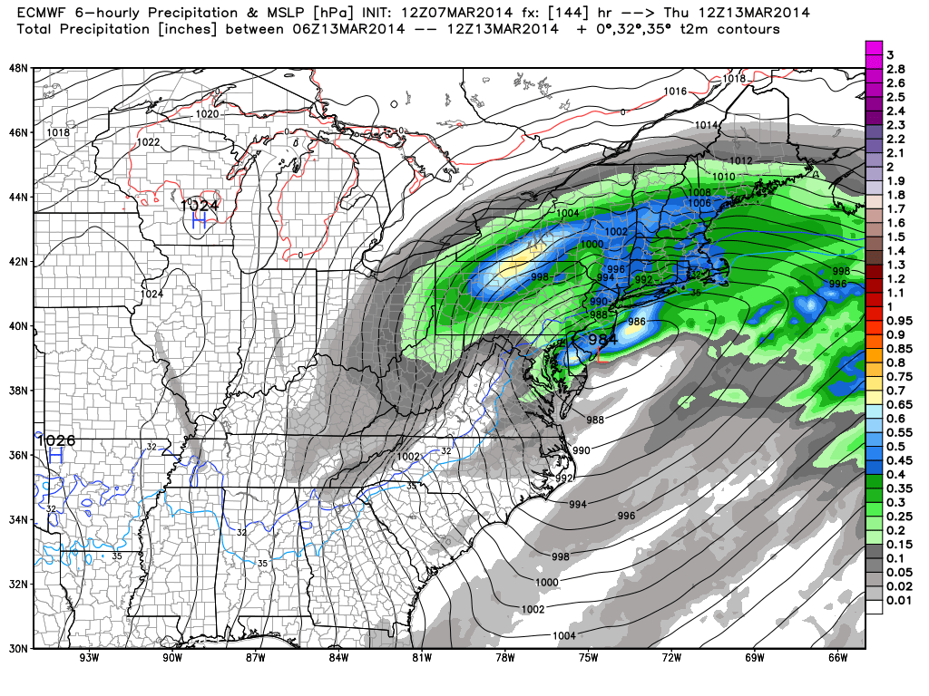
Source: WeatherBell
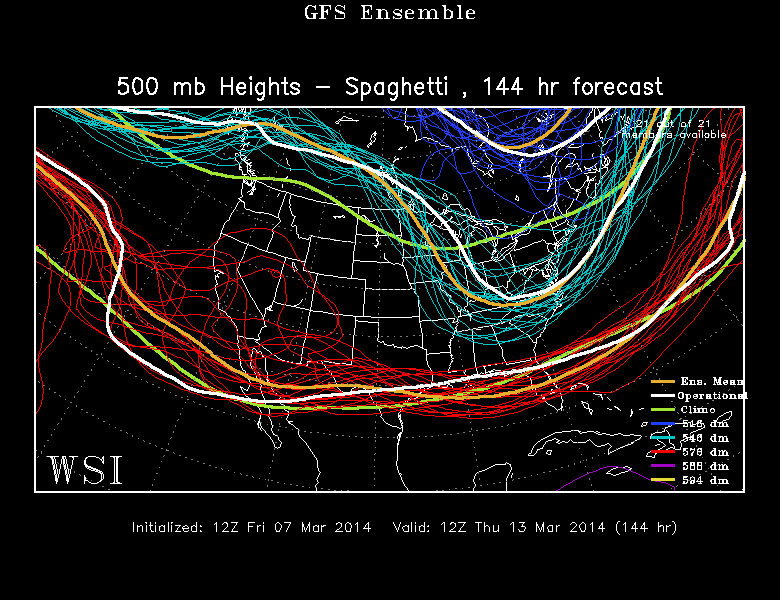
What really helps to tell the story of uncertainty though is in the 500mb spaghetti charts. Below show the ECMWF and GFS ensembles. These are aptly named 'spaghetti charts' because, well, they look like a plate of spaghetti. And they take on this look even more so when you're looking farther out into the future and errors in the modeling of the atmosphere tend to grow. In the short term, these two camps are in great agreement (through Monday). It's after that that they really start to diverge.
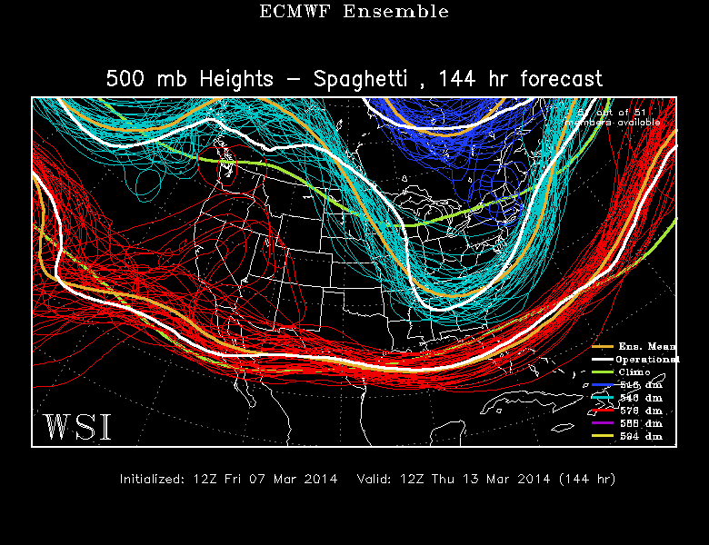
Source: WSI EnergyCast
Not only are their depictions of 500mb heights and trough placement different, but many of the ensemble members of each model are in big disagreement with themselves! Each line represents a different member, and you can see how they vary. This is what suggests very low certainty for now, and anyone claiming to 'know' what's exactly going to happen next week must have the direct line to the man upstairs. We're dealing with potential phasing of 2 parcels of energy, one of which is way out over the Pacific right now and the other over the North Pole. It's near impossible to know for sure how they will interact 5-6 days in advance.
So we know a storm will born, we know it will impact some of those in the eastern U.S. next week. The question of what exactly develops will become a lot clearer as we head into this weekend. I'd think that by Sunday afternoon/evening we'll be able to better answer the questions of precipitation type. track, and timing. One positive no matter what is that astro tides are low during this time frame, limiting and potential coastal flood threat. And either way it will be cold following this one, leading into St. Patrick's Day Weekend. Let's hope we don't have to plow the streets for any parades!