Close To A Foot Of Heavy, Wet Snow Coming Wednesday
BOSTON (CBS) - Is it just me or does it seem like this winter has gone on forever?
Don't those hot and humid summer beach days seem like a lifetime ago? Heck, at this point I can hardly remember Labor Day or even Halloween! Isn't it amazing how much our landscape can be changed over the course of a few months?
Well, if you're looking for signs of spring, you're going to have to wait a bit longer. We are about to plunge deeper into the depths of this cold snowy winter.
Check: Current Conditions | Interactive Radar | WBZ Weather Blog
Historically speaking, the first few weeks of February are amongst our stormiest and snowiest. Just think back one year ago to the Blizzard on Feb 8-9, or back to the Great Blizzard of 1978 which happened Feb 5-7. Typically, our atmosphere is ripe for big storms this time of year and this February will be no different, with two possible snow storms in the next 5-to-7 days.
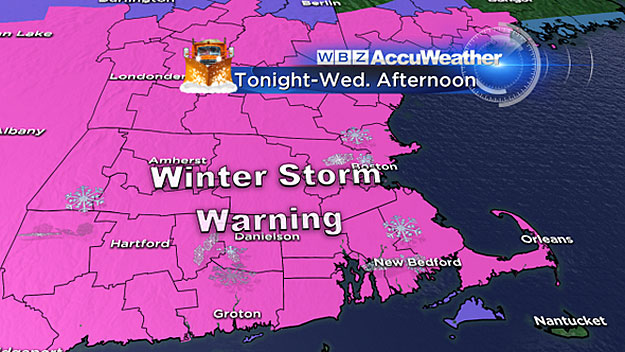
A Winter Storm Warning has been issued for Massachusetts and southern New Hampshire from midnight to 6 p.m. Wednesday.
There are no big changes to the forecast from Monday, (not sure that is good news), so let's take you through, inch-by-inch.
TIMELINE
Midnight through 7 a.m. Wednesday: Snow begins from west to east mainly between 3 a.m.- 5 a.m. It will come on fast, ramping up pretty quickly to a very steady, accumulating snowfall. So by the time most folks hit the roads for the Wednesday morning commute it will be snowing steadily and the roads will be covered with an inch or two.
7 a.m.- 1 p.m. Wednesday: We will be in the "teeth" of the storm during these hours. This storm is what we call "front end loaded" with a big thump of snow at the beginning. Snowfall rates will average 1-to-2 inches per hour in the morning and early afternoon on Wednesday, quickly deteriorating the roads across the region. A rain/snow line will start to creep northward in this time frame, changing the snow to rain over the Islands and parts of Cape Cod. Expect a widespread 4-to-8 inches on the ground by 1 p.m. everywhere north of Cape Cod and the South Coast.
1 p.m.- 7 p.m. Wednesday: Lots of changes in these late hours of the storm. The snow intensity will lessen by late afternoon and it will only be heavy in pockets and bands. Also the rain/snow mix line will continue to move northward up through the South Shore, perhaps even bringing some sleet as far north as Boston late in the day. Snow amounts will vary widely in this time frame, some picking up an additional 6 inches while others will be mixing and get very little additional snowfall. By 7 p.m. Wednesday nearly all of our accumulation will be over.
ACCUMULATION
Here are the final expected totals:
One-to-3 inches over the Islands and Outer Cape
Three-to-6 inches for the rest of Cape Cod and the South Coast up to Plymouth
Six-to-12 inches for just about everyone else including Boston, Worcester and all points north and west.
In fact, most areas will be between 8-to-12 inches, lots of towns will be reporting 9, 10 and 11 inch amounts.
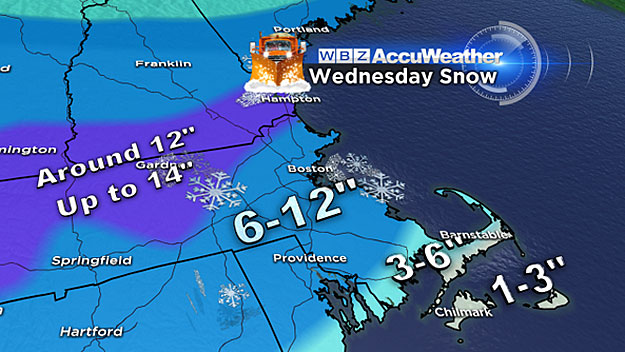
There will be areas that will "overachieve." This has happened with just about every storm this year. A heavy band will set up and sit over a few areas and push snow totals over 12 inches. So I would fully expect some spot 13 or 14 inch totals. One such area may be the Worcester Hills and parts of southern New Hampshire.
This will be a very heavy and wet snowfall unlike most of our Arctic-like storms from January. This will be back-breaking type stuff to shovel. But on the other hand, it's great for snowball and snowman making.
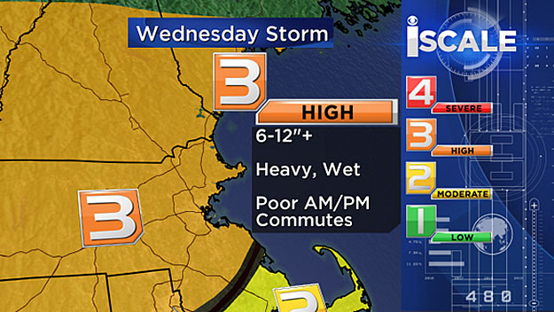
Anytime you get 8-to-12 inches of heavy, wet slop, power outages are a concern. While we do not expect any widespread outages due to the last of any significant wind, there may be some downed limbs and power lines.
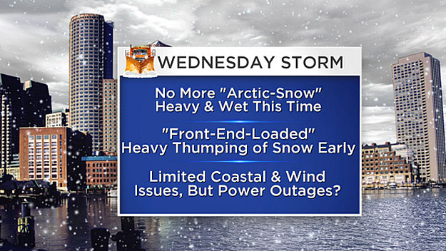
Finally, there are no real coastal flooding concerns with this storm. Winds will gust 20-to-30 miles per hour, not really up to par or worthy of "nor'easter" status. We can save that term for our next potential storm Sunday and Monday.
Follow Terry on Twitter @TerryWBZ
MORE LOCAL NEWS FROM CBS BOSTON


