Significant Amount Of Wet, Heavy Snow Expected Wednesday
BOSTON (CBS) - One down and well, at least a few more to go. February looks to be shaping up as a very busy month in the weather office. All we can do is take 'em one at a time, next up: Wednesday.
Wednesday's storm will be much more significant than the Monday event for several reasons. It will encompass all of New England, dump significant amounts of heavy, wet snow and impact both the morning and evening commutes.
A Winter Storm Warning has been issued for most of Massachusetts and southern New Hampshire from midnight to 6 p.m. Wednesday.
TIMELINE:
The snow begins between 3-6 a.m., from west to east. It will be snowing at a steady clip during the morning commute and there will likely be a few inches on the ground at that point. The peak of the storm occurs from about 7 a.m. through 3 p.m. Only 8 hours, but it will snow at an average of an inch per hour during this time frame. After 3 p.m. the snow will taper to flurries but will not completely shut off until after the Wednesday evening commute.
Check: Current Conditions | Interactive Radar | WBZ Weather Blog
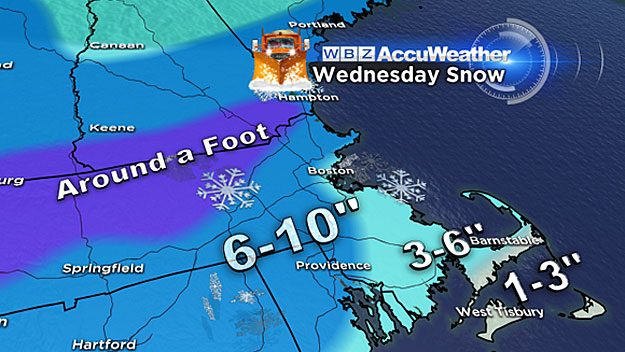
HOW MUCH:
A widespread 6-to-12 inches of snow is likely for nearly all of southern New England. I think there will be a lot of towns in the 7-to-9 inch range with this one. The highest amounts (10-to-12 inches) may occur in the Worcester Hills and parts of southern New Hampshire. As with any storm we will be watching to see if any localized heavy bands set up, this could happen almost anywhere and lead to higher (jackpot) totals. Along the South Coast and over Cape Cod some mixing with sleet and rain is likely during the late morning-early afternoon time frame. Snow totals will ramp down significantly in these locations to around 3-to-6 inches in southern Plymouth down to the upper Cape, 1-to-3 inches of slush and slop on the outer Cape and Islands.
OTHER CONCERNS:
There will not be much wind to contend with nor will there be any significant coastal flooding, basically a straight forward old fashioned snow storm. I am slightly concerned with the potential for some scattered power outages due to the heavy, wet nature of the snow, that's something to watch out for. Also, there may be an area of icing (near the rain/snow line) in southeastern Massachusetts and some ice accretion is possible on untreated surfaces.
WHAT'S NEXT:
We get a few days off to end the week, but the biggest storm may be yet to come. We are watching the potential for a large, nor'easter-type storm later in the weekend, perhaps later on Sunday and into Monday.
Too early for specifics here, but just something to keep in the back of your mind if you have weekend plans.
Follow Terry on Twitter @TerryWBZ
MORE LOCAL NEWS FROM CBS BOSTON