3 Storms Expected In Next 7 Days
BOSTON (CBS) - The groundhogs may have finally gotten one right. Both Punxsutawney Phil and our local hog Ms. G crawled out of their slumber (or perhaps were rudely awakened) early Sunday and saw their shadows.
Check: Current Conditions | Interactive Radar | WBZ Weather Blog
This one was so easy even a groggy, hungry groundhog couldn't miss. In what may have been the easiest forecast of their careers they both predicted 6 more weeks of winter, a forecast I doubt many meteorologists would disagree with.
It almost felt like spring this weekend, right?
Temperatures topped 50 degrees in many spots on Sunday, the leftover snow and ice piles started to recede, no doubt, many of you started thinking ahead towards milder, brighter days. Got sping fever? I would advise against reading on or looking at a 7-day forecast, winter is about to make a big comeback.
What a way to start the month of February. Not one, not two but three storms in the pipeline for the next 7 days.
Here we go.
Storm #1 is Monday
This is a "minor" event, just getting "fringed" by a storm well to our south.
Timing: The first flakes fell over far southeastern Massachusetts around dawn and the steady snow began after 7 a.m. By 10 a.m. the snow overspread most of southern New England. The "heaviest" snow will be mainly along and south of the Mass Pike. It will taper off late in the afternoon and will exit the southeast coast and Cape Cod between 6-8 p.m.
How Much: Very little, about an inch or two along the Pike in and around Boston. Off to the north and west just a coating to an inch; very little if any accumulation in southern New Hampshire and Vermont. The "jackpot" will be in southeastern Massachusetts, including the Cape and Islands where 2 or 3 inches will be common, perhaps a few spot 4 inch totals.
Storm #2 is Tuesday night into Wednesday
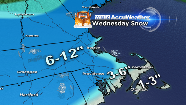
This one has a mich bigger potential to impact the entire area. Some delays and closings are likely. A "moderate" event.
Timing: Snow should break out after midnight Tuesday night, a few inches may be on the ground by the morning commute on Wednesday. This will be a quick mover, steady and heavy snow expected for only about 6-to-10 hours, tapering off during Wednesday afternoon. Most snow accumulation will occur between 7 a.m. and 1 p.m. Wednesday.
How Much: Where it stays all snow, likely from Boston north and west, 6-to-10 inches are possible. There will be a rain/snow/mix line which will work northward during the morning on Wednesday. At this point, it looks like it will stay south of Boston, perhaps getting as far north as Plymouth area. Amounts will taper quickly in the mix zone, down to 3-to-6 inches or so near Plymouth and less over the Cape.
Storm #3? "Major" event?
It's way too early to make any kind of call on a third storm BUT, there is big potential centered around late next weekend/early next week for a significant coastal storm. This COULD be the biggest of the three storms and has nor'easter-type potential. A complex atmospheric setup is on the way, so it's going to be a while before we can nail this one down.
Six more weeks of winter?
The way this winter has gone, sounds like a piece of cake. Let's hope that is truly all that is left.
Follow Terry on Twitter @TerryWBZ


