Bitter Cold Follows Historic January Nor'easter
BOSTON (CBS) - Congratulations!! You just made history…by making it through this January nor'easter you can now say that you survived the 5th greatest January snowstorm on record! That is no small feat given our National Weather Service records go back about 140 years.
Actually I must admit that I am a bit surprised by this stat, doesn't it seem like there must have been more than 4 other storms in the history of January's that were much larger? Boston received 15.1" over the span of Thursday and Friday just beating out the old #5 storm…perhaps you remember this one, 14.7" on January 28th, 1897…OK maybe not.
I have more interesting snow stats for you…
-This storm was our greatest snow producer since the blizzard back in February …but in my mind, the two really don't compare…we had 24.9" during the blizzard and the winds and coastal flooding were much more severe
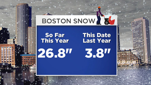
-Boston is now up to 26.8" of snow for this winter season…this is about 17" above what we would "normally" have by this date
-On this date 1 year ago (Jan 3, 2013) we had only 3.8" for the season! What a difference a year can make! But as you may remember, we made up for the slow start with a snow blitz in February and March last winter.
-Even if we didn't get another flake of snow this month, January of 2014 would still go into the record books as snowier than normal…we average about 13" in January.
Ok, enough of that…now on to the next big weather story…the cold.
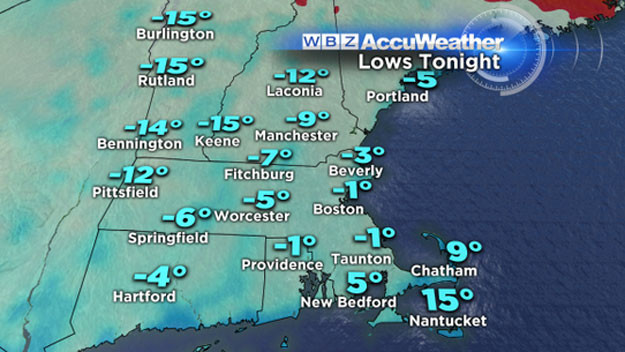
Many times some of our biggest snowstorms are followed by bitterly cold air. This was true of the blizzard in February, the following day was one of our coldest of the winter season…we had a high of just 20 and a low of 15 the day after. Well that is child's play compared to what is following this storm. Low temperatures tonight will drop below zero for most of the suburbs, in fact Boston has a chance to dip below zero as well. If Logan were to go below 0, it would be the first time in 3 years (Jan 24, 2011, -2). While it is unlikely, we have an outside shot at a new record as well, that was -4 degrees set back in 1981.
Watch Barry Burbank's Forecast
At least the winds are going to die off Tonight…wind chills will range between -10 and -20, but could have been much worse given the extremely low air temperature.
In classic New England fashion, we will make a quick rebound this weekend. Would you believe that by Sunday many towns will reach 40 degrees and it will actually be raining Sunday night and Monday? Amazing to think that after the Alaskan-like snowstorm we just had with the lightest, most powdery snow you could imagine that just a few days later we will get rain, not snow.
However, don't think we are in for a January thaw, the temperature roller coaster is going to back down a steep hill next week…Another blast of bitter, Arctic air is set to blanket much of the Midwest and Northeast. While we won't see the worst of the cold (That is reserved for the upper Midwest), it is going to be a pretty frigid 48 hours. We will spend about 24-36 hours in the single digits and teens on Tuesday and early Wednesday. Just adding to what is one of the coldest winters (so far) that we have seen in the northeast in many, many years.


