Nor'easter To Bring Foot Of Snow, Followed By Bitter Cold
BOSTON (CBS) - It didn't happen last winter until February and it never happened at all in the winter of 2011-2012. We have been void of early season, significant snow storms in Boston in recent years, but 2013-2014 is proving to be a very different story.
Blog: Nor'easter Update
We are about to get our second 6 inches+ snowstorm in Boston and the season has barely just begun.
Nor'easter 2014 has arrived. It may take a while to get revved up but once we get there it is going to pack a significant punch.
And that, is where the story begins.
DON'T BE FOOLED
The storm is going to feel pretty wimpy for most of the day Thursday.
I am guessing a lot of parents are going to say, "they cancelled school for this?" The storm was never forecast to start with a bang. In fact, the storm will spend most of the day gathering itself together over the southeastern United States. Our snow during the day is really just an initial weak band separate in many ways from the "real" storm.
Furthermore, it is very likely that there may even be a bit of a lull in the action for a good portion of this afternoon and early evening where it is just sort of flurrying here and there and not really accumulating.
I can see the "flurry" of angry emails now asking what all the hype was about. I assure you, the storm will come, just be patient.
Check: Current Conditions | Interactive Radar | Forecast Maps | WBZ Weather Blog
ACCUMULATION WILL RAMP UP QUICKLY
Through noon there will only be some additional scattered dustings to an inch or so here and there. And then between noon and 5 p.m., probably next to nothing in addition.
At worst there may be 1-to-3 inches in spots by the end of the evening commute. I would imagine with the slow accumulation and fluffy nature of the snow, road crews will be able to keep up quite easily.
After dark, there will be noticeable changes. The east-northeast winds will be ramping up, the snow will be filling in on the radar and visibilities will be lowering, especially near the coast where winds will be strongest and some ocean-enhancement may beef up the snow rates.
I would expect an additional 2-to-4 inches between 5 p.m. and midnight.
From midnight through dawn, things get serious.
This is the time frame where the nor'easter will earn its name. Steady, moderate snow will combine with strong northeast winds to create near whiteout conditions in many areas in eastern Massachusetts.
I would expect an additional 4-to-8 inches to fall in this time frame.
In fact, close to the coast from Cape Ann to Boston, down to the South Shore and over parts of southeastern Massachusetts, there will be periods of "blizzard" conditions.
An official blizzard is defined as sustained winds of 35 mph or greater AND considerable falling and/or blowing snow, frequently reducing visibilities to 1/4 mile or less for 3 hours or more.
It is kind of a mouthful, but put simply, the wind and the snow combine to make driving and existing outdoors nearly impossible.
There will be significant blowing and drifting of the snow with the fluffy nature of it and the strong winds, so trying to measure it may be challenging.
It will be the kind of storm where on one side of your car it will look like 4 feet of snow fell and on the other side there may be next to nothing.
After 8 a.m., the snow will taper off from west to east, last to end over Cape Cod around midday. There may be an additional inch or two in this time frame in extreme eastern areas.
SO HOW MUCH?
The highest amounts will almost certainly be in eastern Massachusetts - inside Route 495 from the North Shore, Cape Ann, to Boston and through the South Shore to parts of Cape Cod and inland southeastern Massachusetts. In this zone we are forecasting 10-to-14 inches of snow.
I would expect some heavy ocean-enhanced snow bands to set up. Very localized, these bands could drop an inch or two per hour and potentially push some towns near the coast over 14 inches up to as much as 18 inches!
North and west of 495 I am actually concerned about a "snow hole" of sorts. There may be a fairly sharp drop off between the haves and have-nots with this event. We are forecasting 6-to-10 inches in this area, but I would not be surprised if some towns got less than 6 inches.
COASTAL CONCERNS
This will be the first test of our Coastline this season.
Winds will gust 25-to-50 mph along the entire coast all night long and into Friday morning.
I am not expecting widespread power outages or damage as we will likely remain just below severe thresholds like we saw during the February blizzard.
However, 12-to-18 hours of powerful onshore winds combined with astronomically high tides will cause some coastal problems.
Three high tides will need to be closely monitored, approximately: midday Thursday, midnight Thursday and midday Friday.
Most of the flooding should be minor (some splash over) but there will be pockets of moderate flooding and some vulnerable shore roads may be washed out.
IT'S GOING TO BE COLD
The kids are going to want to get out on Friday and go sledding and make snowmen, but I would seriously advise against it.
Temperatures during the storm wont get above the teens in most areas and they only get colder from there. Highs on Friday will be between 10-15 degrees and wind chills will remain well below zero all day.
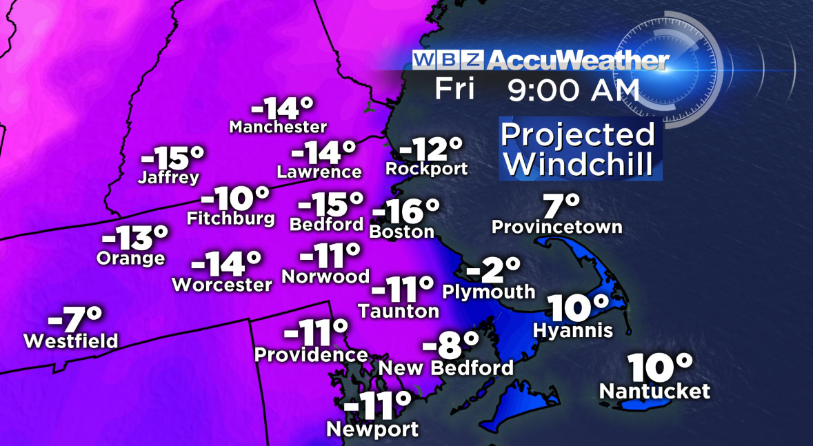
We may see record setting cold by Saturday morning.
In fact, Boston could dip below zero for the first time in a few years.
So in the end, it won't go down as an historic storm or one our most memorable, but it will likely be one of our strongest, most significant and impactful of this winter season.
Travel should be avoided if possible late Thursday night through mid-morning Friday.
And as always stay tuned for updates or changes to the forecast!
Follow Terry on Twitter @TerryWBZ
Watch Barry Burbank's Latest Forecast: