Cold End To 2013, Snowy Start to 2014!
Find Eric Fisher on Twitter and Facebook
Some of us are still on vacation celebrating the holiday and staying out of the commuter rat-race for a few more days. Others are enjoying the slopes up north. And the rest of us are trying to get back into the swing of work. But one thing is universal for us all - we'll be getting knocked around by winter this week. The cold is a given, and a snowstorm may bury parts of New England by Friday. In the middle, New Year's Eve! Let's get this party started.
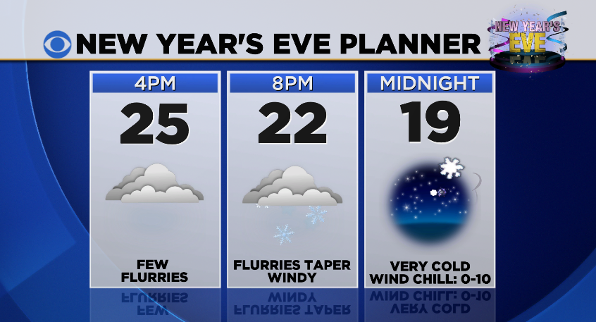
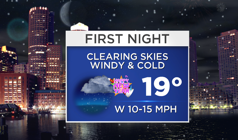
Up first the cold, which was reinforced by an Arctic front this afternoon. Temps will nose dive back into the 0s and 10s overnight under clearing skies. A frigid start to the final day of 2013! A weak clipper will swing on in during the afternoon and evening, but this one isn't the 'bomb out off the coast' type. It's starved for moisture, and will produce only scattered snow showers and flurries (along with clouds). Doesn't look like anything major, and shouldn't bring much of an impact re: your travels to NYE destinations. Snow showers will wrap up in the evening, and we're in for a cold celebration this year. Temps should be back into the 10s for most by midnight, but wind chill values will be in the 0-10º range. So if you're heading outdoors to revel in the final minutes of the year, bring along plenty of layers to keep you warm! Foot and hand warmers may not be bad fashion choices. And a warm beverage won't hurt, either :-)
Alright - now onward to the snow show. Lots of chatter on this one right now, but there is still a pretty high level of uncertainty regarding exact strength and track (as there often is 3-4 days out). Let's start off with 10 things we know tonight:
1) Plenty of cold air with this one - probably no precip issues (all snow)
2) In fact, so cold that most of the snow will be very light and fluffy, meaning high snow ratios (maybe 18:1 to 25:1 for most of the interior!) Only potential wet snow threat looks to be near Cape & Islands.
3) The event will be long in duration, regardless of intensity. Snow will likely begin early Thursday and go all the way through much of Friday
4) At least 6" looks likely for most of Southern New England. There isn't much disagreement there at this time.
5) The 'ceiling' for this event is high. Meaning - if it can crank and stay closer to the coast, some major snow totals are not out of the question.
6) Coastal impacts will be key - slow moving storms with long fetches (distance of consistent wind direction) can affect multiple tide cycles. We'll also be just past 'new moon' phase, so astronomically tides will be running on the high side.
7) Dangerous cold/wind chills may be involved (subzero wind chills during storm)
8) Lesser impacts are expected across northern New England
9) Coastal erosion may be a major factor
10) It will be gone by the weekend
INGREDIENTS:
Like any delicious winter recipe, you've got to have the right ingredients for a snowstorm. Here's what we've got on the table.
COLD - plenty of it, and not going anywhere. Northern tier states seeing significantly below-average temperatures as lobes of the polar vortex swing on down from the Arctic and into our neighborhoods. Believe it or not, the next week (scheduled for next week) looks even more brutal! The west looks best, with no major wintry weather or cold temperatures expected there in the extended.
ENERGY: Currently hanging out in the Gulf of Alaska. This will head down across the country, pick up some moisture from the Gulf of Mexico, and then help form a coastal low by Thursday.
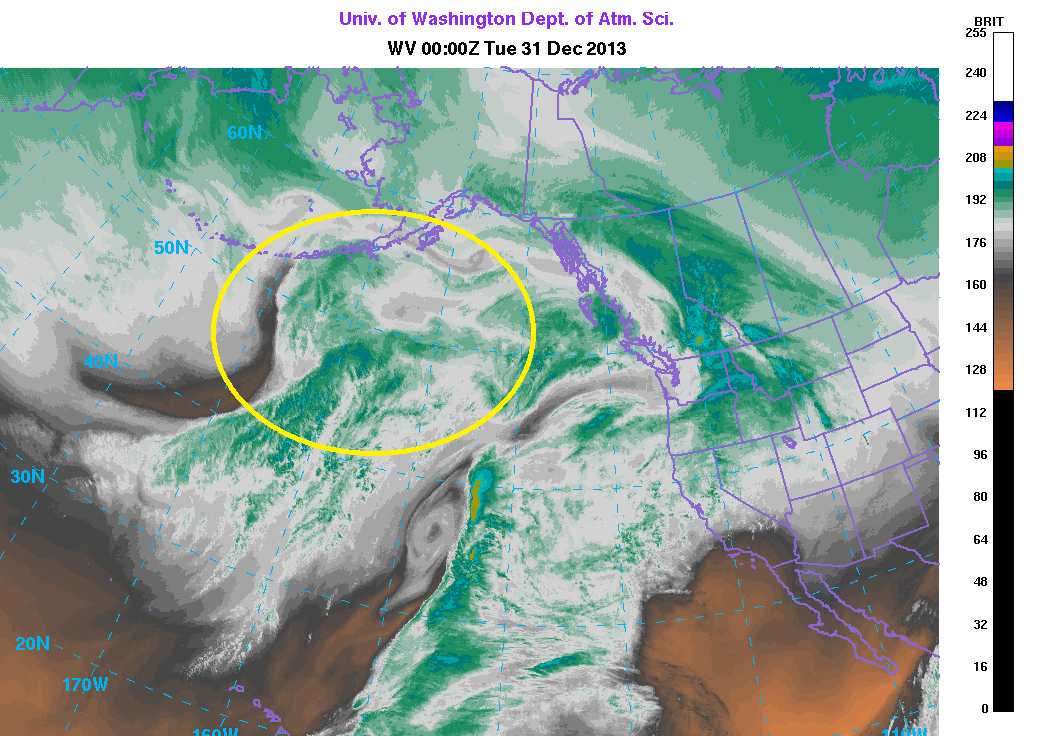
Circled area is where current jet energy is located. Courtesy: University of Washington
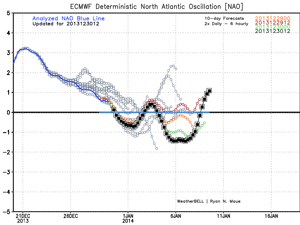
BLOCKING: You hear this term a lot in wintertime across the Northeast. It has to do with strength/position of high pressure in the North Atlantic. When the NAO (North Atlantic Oscillation) goes (-), that means blocking is in place and troughing of the jet stream is usually a predominant feature along the NE coast. This tends to mean stormier/colder weather for us, and the blocking high helps cage in these storms so that they don't just quickly shoot out to sea. It's marginal at best with this one. But while not a spectacular signal, we should go -NAO or netural for this storm and that may help create a long duration event. I'd like to see a stronger signal, personally, to keep this storm closer to our coast. The potential for it to slip out farther to the southeast is higher than snow lovers would like.
If you're into the really geeky stuff, let's dive into a few more of the specifics. The ECMWF has been strongest/farthest north, but has trended farther SE today with its storm track. These little fluctuations are normal and frequent in the days leading up to a storm, especially when phasing of jet energy is involved. You've got to thread a small needle to have things go just right for a big event. The GFS is farther to the SE with its track, and also faster. It brings in the snow quicker on Wednesday night/Thursday am and departs more quickly on Friday as well.
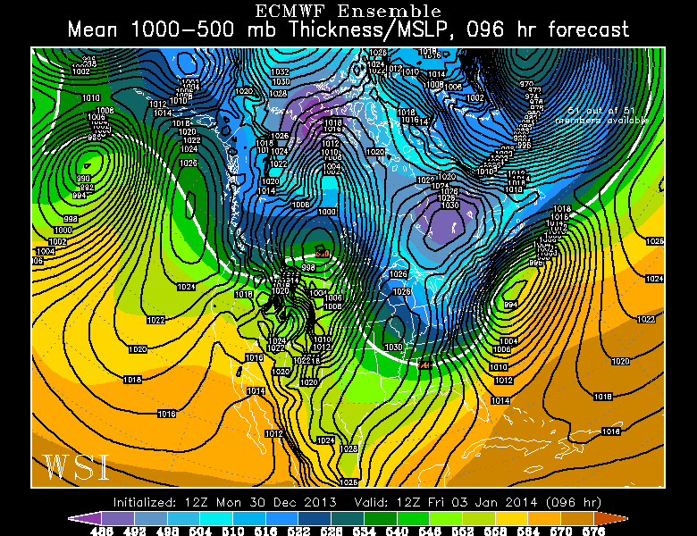
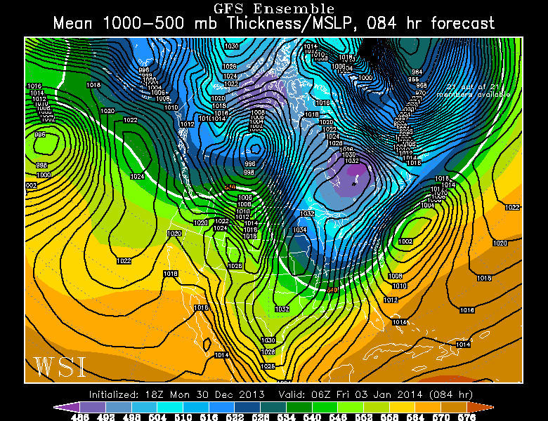
ECMWF and GFS ensemble forecast for Friday. Courtesy: WSI
For what it's worth, the Canadian GEM is MUCH farther out to sea with the storm center. What these varying solutions tell us is that we can't say confidence in the forecast is high just yet. Certainly there are enough solutions with a farther out to sea track to urge a bit of caution in the outcome. While a 6" event seems fairly unavoidable, the MAJOR event is not a given yet.
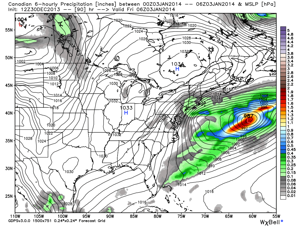
GEM forecast - low center well out to sea. Courtesy: WeatherBell
For giggles, here is the ECMWF snowfall output for the storm through Friday. This is the most bullish of the models right now. Also something to keep in mind when looking at this - the ratio used to get snowfall totals is 10:1. Meaning, you'd get 10" of snow for every 1" of liquid precipitation (if it was rain). That will not be the actual ratio during this storm. It's more likely to be closer to 20:1. So in essence, you could double these totals for a 'ceiling' or 'worst case scenario.'
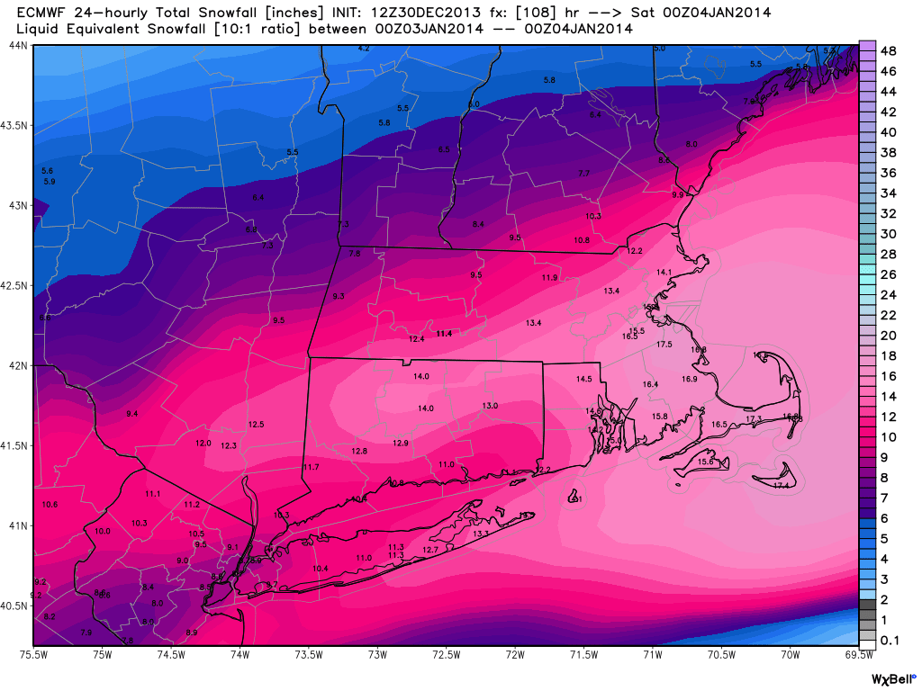
12z ECMWF Snow forecast. Courtesy: WeatherBell
Bottom line is that I don't think we'll be able to escape a plowable snow event here. But I wouldn't be surprised if the trend goes a little farther SE over the next few days. I'd make sure the snowblowers are in working order and think about what you'd do if school/work was cancelled on Friday. I think the snow on Thursday will be light enough so that yes, travel will be quite slow - but not expecting a major shutdown of the state. The peak of the storm would likely be pushed more toward Thursday night and Friday.
Coastal concerns are definitely there, and if the winds can gust up or over 50mph we're talking power outages and significant flooding. That's an aspect to keep a careful eye on. There's often nothing good about 24-36 hours of 30+mph winds generally coming from the same direction (in this case NE to ENE). The combo of a strong Arctic High to the north and a storm to our south helps keep this gradient strong and persistent.
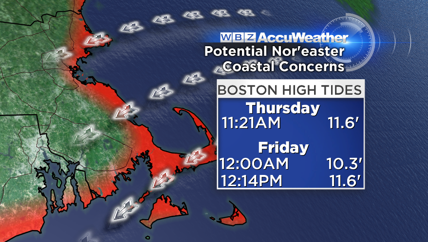
The high tide cycles we'd be most concerned with. It's the Friday afternoon high tide that would likely bring the highest water levels and impact. The tide levels listed are the actual high tide level in Boston *without* storm surge.
No matter where the exact center tracks or how much snow falls, it's all gone by Friday night. With a fresh snowpack and very cold air we could be looking at many subzero lows on Friday night into Saturday morning. Saturday will stay very chilly, but temperatures should moderate a little bit on Sunday. Models are hinting at storm potential for Monday, but not a given at this point. One storm at a time!