Weekend Storm: What You Can Expect
BOSTON (CBS) - We are in for a real thumping of snow for about six to eight hours. Snowfall rates of one to two inches per hour are likely until 6 a.m. Sunday.
At the same time, our atmosphere will begin to warm at all levels, changing the heavy snow over to a mix of sleet, freezing rain and plain rain in some locations. So while the snow is extremely light and fluffy tonight, it will be heavy, wet and in some locations topped by a layer of ice Sunday morning.
WINTER STORM: Current Conditions | Interactive Radar | Weather Blog | Share Weather Photos | iScale | Closings
The timing of this changeover is critical to final snow totals. If the changeover occurs just an hour or two later, we could be in for 2-4 inches more snow than forecast. If it comes in an hour or two early, our snow forecasts will be too high. At any rate, where the change to ice and rain does happen, what actually fell as snow overnight will be compressed and packed down, so 8 inches of snowfall may look more like 4-6 inches by the time you go out and shovel. A complex storm to say the least.
Here is how we see things breaking down for each region in Southern New England:
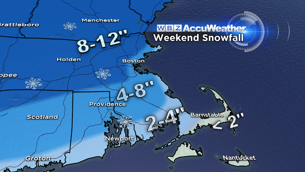
Cape Cod and the Islands:
Snow will change to rain first in this area, right around midnight or 1 a.m. Therefore, we are only forecasting 1-2 inches of snow, which will all be washed away by morning.
Southeastern Massachusetts:
This region includes the entire South Shore and South Coast. We are predicting 2-4 inches of snow in this region and a change to rain between 2 and 4 a.m. Again, most of the snow will be washed away.
Boston area, immediate suburbs:
We are forecasting 4-8 inches in the city and nearby suburbs, with a change to rain around 5 a.m. This will leave a few inches of slop to clean up, but it will look nothing like 4-8 inches in the end.
North and west of Boston:
In the 128/495 area north and west of Boston, we are forecasting around 8 inches, plus or minus an inch or two. This area will also change to sleet and eventually rain from 5 to 7 a.m. before tapering off all together after 8 a.m.
Farther north and west:
In northwest Middlesex County, Northern Worcester County, and Southern New Hampshire, the cold air is really going to try to hold in tight at the very lowest level of the atmosphere (ground level).
In fact, we may struggle to ever get above freezing in this region. So we are forecasting 8-12 inches of snow, with a change to sleet and freezing rain. There may be an icy glaze on everything, making travel and cleanup treacherous.
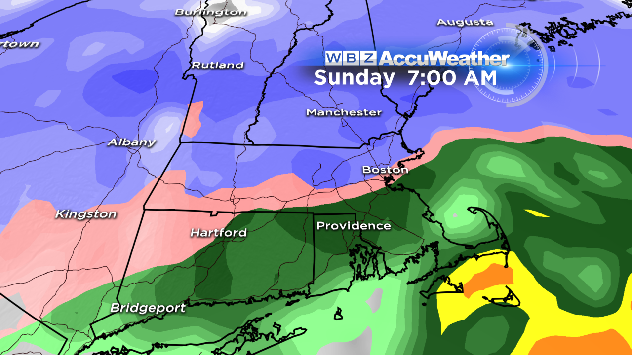
Again, the storm is over by mid-morning Sunday and in most locations you should be able to go on about your day by lunchtime and afternoon. But beware that this warming and changeover will make the snow heavier, wetter and harder to move then we originally thought, and anything you don't get off the driveway will freeze up Sunday night and Monday
Highs on Monday are only expected in the 20s, with a little more snow on Tuesday.
MORE LOCAL NEWS FROM CBS BOSTON


