Winter Storms This Weekend; Likely To Affect Monday AM Commute
BOSTON (CBS) - Here we go! Snow is in the forecast not once but twice this weekend, break out the shovels and boots, winter is about to get serious!
We are tracking two wintry storms, neither one of them a major deal, but both with a mixture of precipitation types and some potential headaches.
Storm #1
This one is already here - a long line of rain, ice and snow extends all the way from Nova Scotia, to Massachusetts to Texas.
While this is creating major travel troubles for a good portion of the Midwest, it will not be as potent for us here in New England. The off and on rain showers Today will gradually change over to sleet and snow Tonight as much colder air pushes in.
It will likely be snowing in Central and Western Massachusetts between 6-10pm. The changeover will occur a bit later in Boston and nearby suburbs, likely closer to midnight. Snow will be falling just about everywhere between midnight and 5am and then it will all be over.
SEE ALSO: Beyond The Forecast Blog
By the time most of you wake up, the snow will be done.
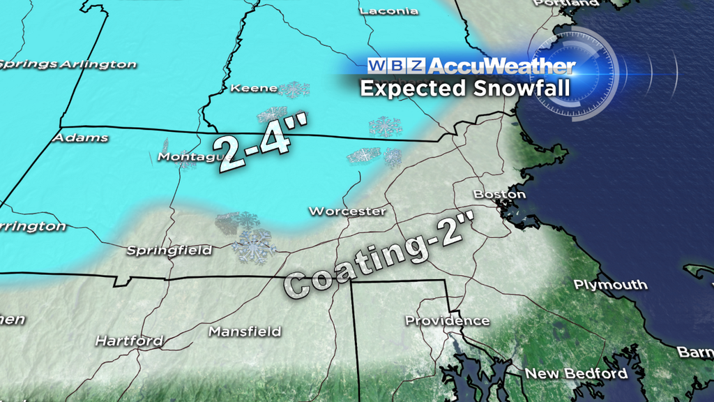
So how much? Well this all depends upon how quickly the cold air works in and the snow can start sticking. Looks like a coating to 2" in Boston and all the nearby suburbs, little or no snow from Cape Cod to the South Coast and South Shore.
Farther north and west, north of the Mass Pike and West of I-495, there will likely be higher snow totals. We are forecasting 2-4" in this zone including northern Worcester County and southwest New Hampshire. In some of the higher elevated locations, especially the Berkshires there may be as much as 6" of snow.
Storm #2
Less than 48 hours after storm #1, we have our next weather challenge.
This one is a bit different. First, we will have some very cold air to start with, high temperatures on Sunday will only be in the mid 30s. This cold air will be very hard to scour out. Storm #2 wants to be a warm storm, its track is going well west of us and it is coming right out of the warm waters of the Gulf of Mexico.
SEE ALSO: Current Conditions | Interactive Radar
However, it will be running into a solid wall of cold high pressure, this will force this warm-thinking storm to begin as snow for all of Southern New England.
Snow should break out around midnight Sunday night and continue through the Monday AM commute. I expect that it will be on the light side, this is by no means a nor'easter or major event. There will be very little wind, no coastal issues, only a variety of precipitation and a morning commute to deal with.
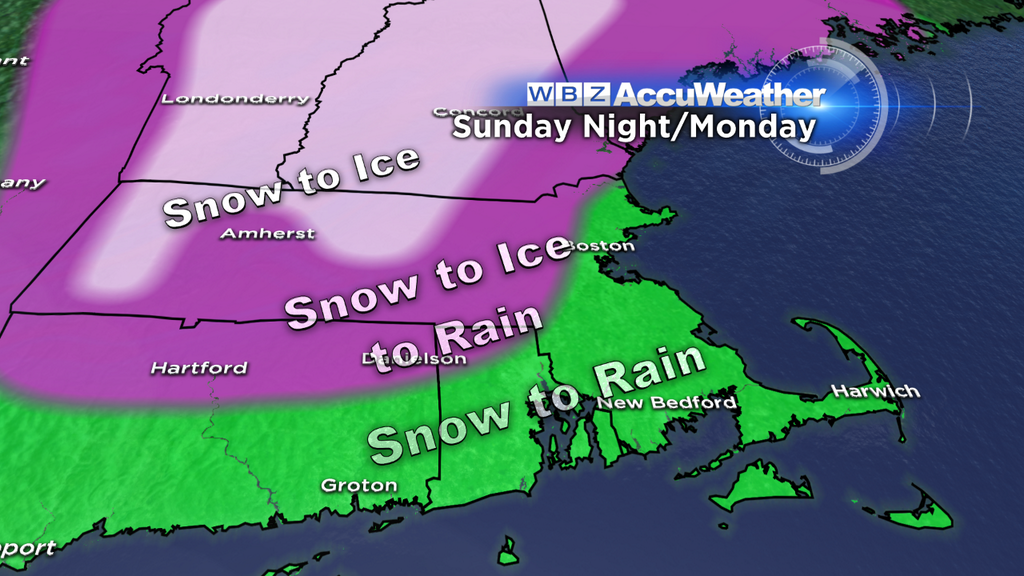
The snow will gradually change to an icy mix and to rain for most during Monday morning, but it will take a while to do so. Along the Coast, including Boston and all of Southeastern Massachusetts, this change to rain will happen first, likely during the AM commute on Monday. To the north and west, around 128 and 495 there will likely be a prolonged period of sleet and freezing rain falling on top of the earlier snow.
So, if you are commuting from the northwest on Monday morning, you may be in for a long, slippery ride. These areas will eventually warm and switch to rain, likely by late morning or midday Monday. The last to see significant warming will be those out in Northern Worcester County and parts of southwest New Hampshire (elevated areas), it may take almost all day to get above freezing in these spots.
Cold air will hold firm and be near impossible to remove at the ground level. Warmer air will flow in at higher levels of the atmosphere though, halting the snow, but perhaps leading to a good deal of icing.
More on this as we get a bit closer. A bit early to call snow totals, but I would NOT expect more than 3-6" anywhere with all the mixing that likely to occur. The bigger issue with storm #2 will be the variety of precipitation and icing.


