Big Weekend, Mainly Quiet Weather!
Find Eric Fisher on Twitter and Facebook
Ho-hum another great day. In fact, the 6th day so far this October with a high temperature 70º+ at Boston Logan. 15 of the first 18 days of the month have featured at or above average temps, and each day through Tuesday should feature more of the same. But once we head into next week, a major shift in the jet stream will cool things down.
First up, eclipse photos! In short, the penumbral eclipse was not exactly spectacular (although the full moon was). Very faint indeed, but these photos sent in by a couple of our viewers show the earth's shadow nicely.
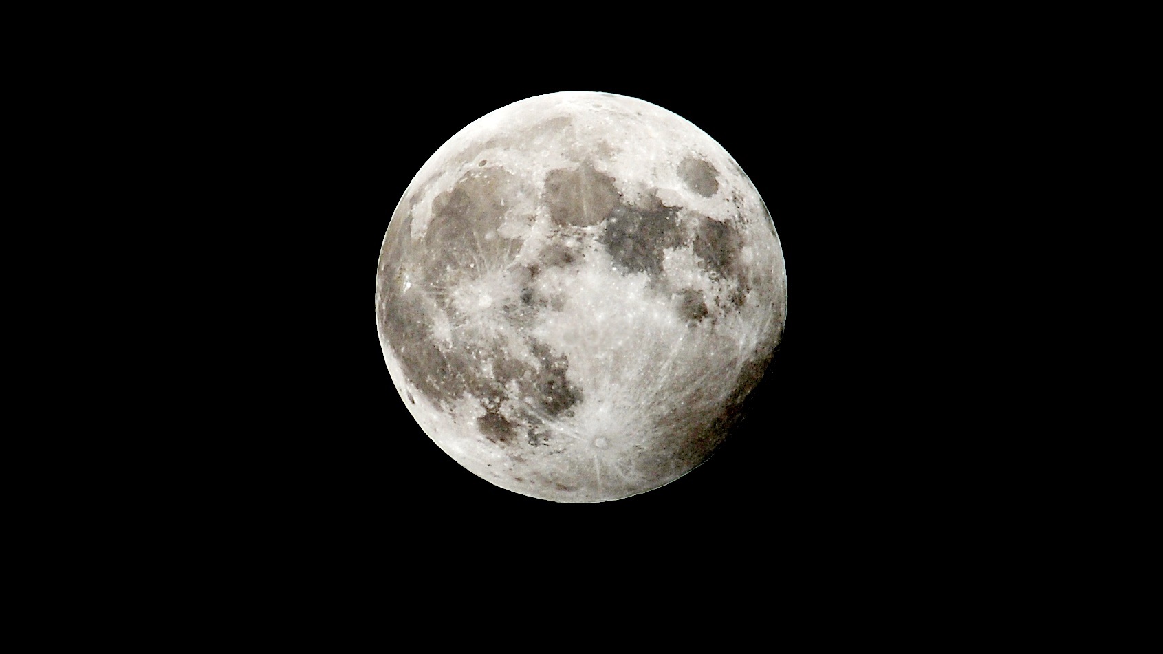

From Bill in Salem, NH (top) and Keri in Dracut (bottom)
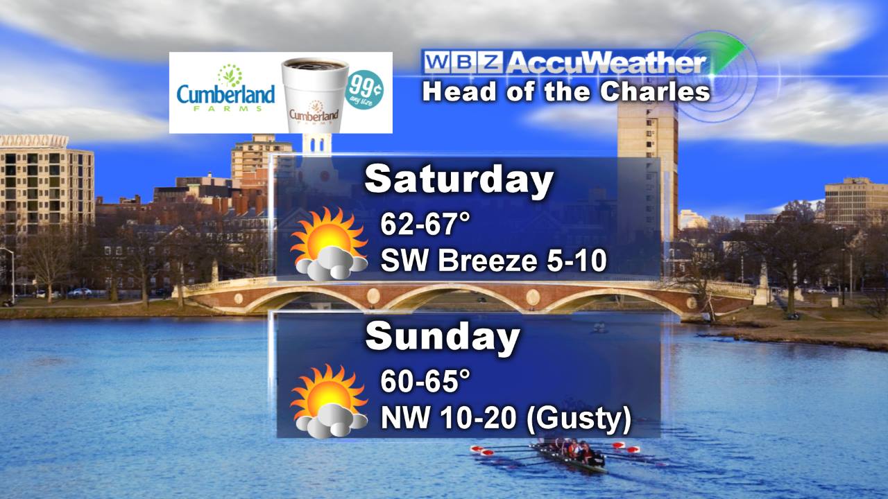
It's a big weekend for Boston and New England in general. We've got the Sox looking to punch a ticket to the World Series (!!), the Pats down the road in New Jersey, the Head of the Charles Regatta drawing hundreds of thousands to the river, the Welfleet Oyster Festival, Keene Pumpkin Festival, fall foliage peaking locally...the list goes on! And the vast majority of the time we'll be able to enjoy nice weather for all those things.
First we'll take in a chilly night in the upper 30s/low 40s with a gorgeous full Hunter's Moon in the sky. Saturday starts off crisp with gorgeous sunshine, and temps will bound back up into the mid 60s. We'll watch high clouds start to filter in during the afternoon, and the cloud deck may get rather thick along the South Coast, Cape, & Islands during the afternoon. Some drizzle or light shower activity may also graze the Islands by dinnertime.
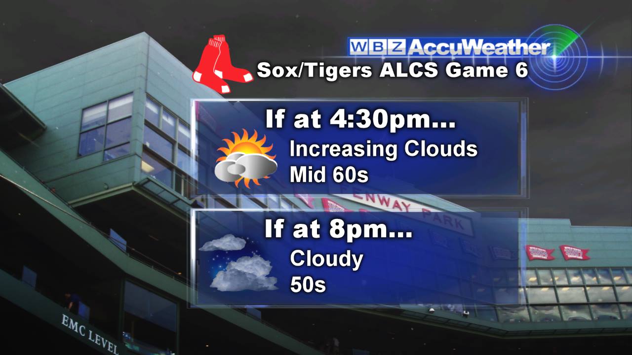
We'll be watching those showers for the big match-up at Fenway Park. I think the best play will be to bring the rain gear along, just the play it safe. This is especially true if the Dodgers win and the game is played at 8pm. If the Cardinals win and the Sox play earlier, rain should not be a factor at all. Let's hope we don't need a game 7 and the good guys wrap this thing up!
A cold front will sweep through Saturday night, and bring a smattering of light showers along with it. I don't expect anyone to see more than .20" of total rain from this system, barely enough to water the grass or your mums. Any lingering showers should wrap up very early on Sunday morning, with clearing skies and a mostly sunny day to follow. A gusty WNW breeze will be in the 10-20mph range, which may make for a little chop in the Charles River. Still, much better than some of the other less desirable conditions we've dealt with for the regatta in the past!
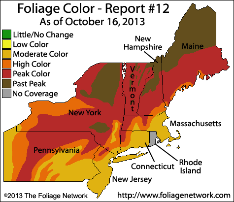
Current foliage report from the Foliage Network
High pressure builds in for Monday, and with light winds in the morning temperatures may be able to dip down to 32º in spots. So we may kick off the week with a frost, especially north and west of Boston. Otherwise bright sunshine and more beautiful weather to start the new week. Tuesday looks mild as yet another front approaches, and some showers will accompany that front by late in the day.
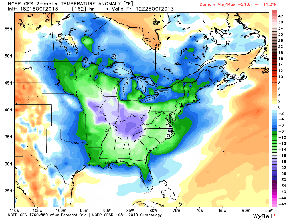
Then the hammer drops and MUCH colder air will invade not just the Northeast, but much of the entire eastern half of the Nation. A big swath of temperatures -10 to -30º below normal will cover a big old chunk of America. I suppose it's about time; the fall has been nothing short of glorious so far!
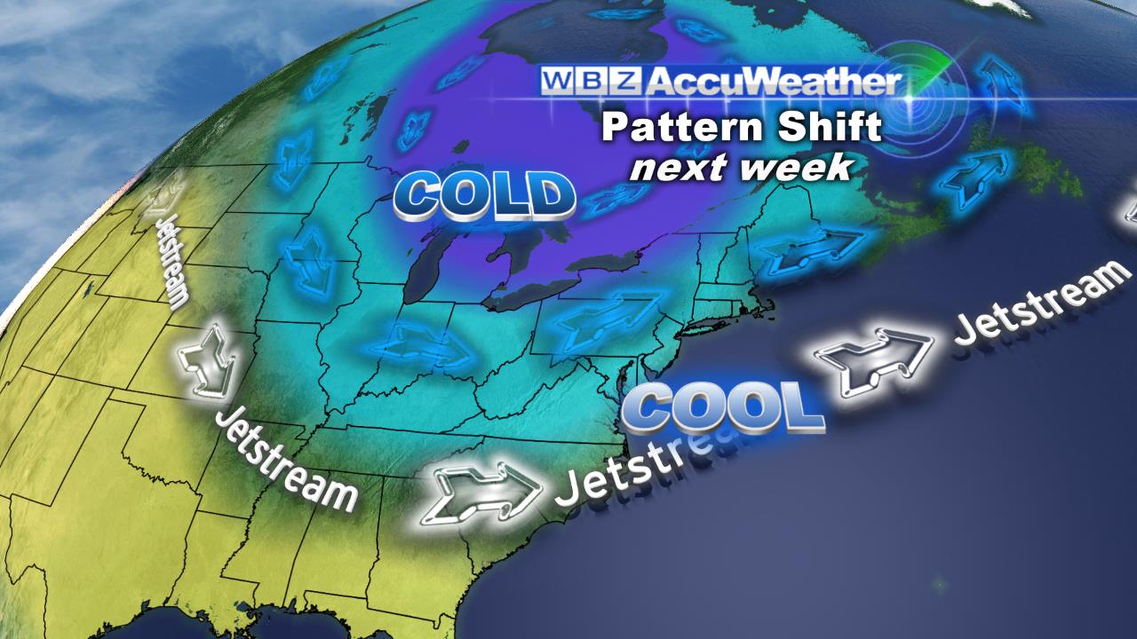
We'll start to feel the cold air on Wednesday, and then it will really settle in Thursday through Saturday. Highs will stay in the 50s, and some higher terrain may not even be able to make it out of the 40s late next week. Some snow showers for higher elevations of the Northeast aren't out of the question either, and lake effect snow may kick in across the Great Lakes. So get ready for a dramatically different end to October compared to what we've enjoyed leading up to the final week. It should also bring the first widespread freeze to the region, ending what's been an excellent and long growing season.
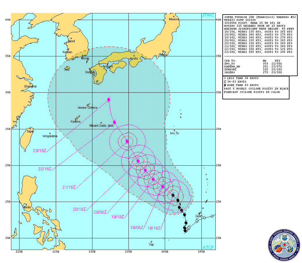
The Atlantic Basin is still completely quiet in terms of tropical activity, and we may be able to declare the season dead soon. Not much fanfare this year, which is a good thing! However, it's quite busy in the western Pacific. A monster super-typhoon named Francisco is churning there, and will head toward Japan in the days to come. People there will be watching this one closely, as it may be a high-impact for them next week.
 Francisco Satellite Loop