Cut-off Low - Weatherman's Woe! (And an Earthquake!)
Find Eric Fisher on Twitter and Facebook
That's how the old saying goes amongst weather prognosticators! There can be nothing more frustrating in terms of both a forecast and for all of us who have to live through the conditions cut-off lows can bring. The people in North Carolina and other parts of the Mid-Atlantic are most acutely feeling that way, as they'll be dealing with the most rainfall & cloud cover from this beast. But here in New England, it's the living on the edge that's the focus of our attention.
They're called cut-offs because the areas of low pressure are 'cut-off' from the main jet stream flow. In fact, there's actually a ridge of high pressure over much of the Northeast and into Southeastern Canada. The storm has become stuck underneath it, with nothing to push it out of the way. We call this setup a 'Rex Block.'
 East Coast IR Loop
The main impacts here will just be cloud cover and a persistent onshore flow of air out of the NE. Actual rainfall will end up being pretty limited. We'll watch showers and areas of drizzle track along the South Coast, Cape, and Islands Thursday night through Saturday morning. I would be surprised if anyone picked up <.25" of rain through Saturday am. More annoying than anything else, this pattern will not budge much since the storm itself is not budging much. If you live north of the Mass Pike, rainfall should be very sparse. Maybe some drizzle, but that's about it. No rain is expected north of Route 2 at all. You can thank strong high pressure to our northeast for that, which is feeding in drier air at the surface and holding rainfall at bay to the south.
Other coastal impacts will include some rough surf and a gusty wind that won't go away for quite a while. A general 10-25mph wind should linger into Sunday morning, with some gusts up to 30mph at times. Wave heights are expected to build to 6-10' just offshore. The National Weather Service has also issued a Small Craft Advisory through at least Friday night.
If you're headed up north early for the weekend, there will be more sunlight and generally quiet/nice weather on Friday, so no worries there! For anyone else across eastern MA, Friday will probably just end up a sleepy, cool, breezy, damp day. Good one for an extra cup of coffee or tea! But no other major impacts from the storm.
As we head into Saturday, a little impulse will dive down from Canada and push a layer of ocean stratus across the region. With a damp onshore flow, that moisture will stay trapped at the lower levels. What that basically means is that we're looking at some persistent low clouds from ME, NH and eastern VT down across MA and RI. Areas of drizzle will accompany those low clouds. The question is - will they lift in time to give us some breaks of afternoon sun? The answer is probably no, but there's at least a chance we'll end up with a brighter end to the day than the start. No significant rain is expected, just some drizzle, so outdoor plans should be manageable.

There's a much better chance for sunny skies, especially in the afternoon, on Sunday. So if you're planning a trip to one of the regional fall festivals or a nice hike in the fall foliage, this would be a better bet. A similar day is setting up for Monday, with temperatures in the mid 60s each day. So overall, I think we'll manage some pretty decent outdoor weather this Columbus Day Weekend, especially after Saturday!
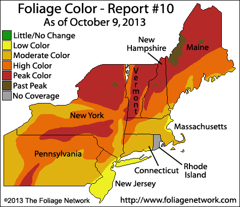
Current foliage status from FoliageNetwork.com
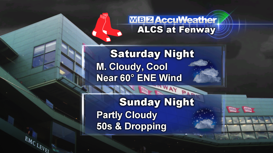
Of course the other big news for this weekend is the Red Sox quest for a World Series! Weather should not be a big issue for either game at Fenway Park. Saturday night looks chilly and damp, which may hold down some home run balls, but otherwise fine. Chilly with mist in the park is perfect for playoff baseball, IMO! Sunday night looks chilly and quiet with some starlight overhead. Go Sox!
Looking into next week, the pattern may become more progressive. There are also a lot of hints that our weather may start to turn colder in the east, with a trough in the jet stream moving toward us. In fact, I can't resist pointing out an oddity in the models that showed up today. This is the GFS 384 hours out, all the way to October 26th. It shows a significant snow storm over the Northeast! In the meteorology community we always chuckle about the oddball scenarios that show up way out in the models, in particular the GFS. Weather prediction is essentially based on chaos theory...and little tiny imperfections in data at the beginning of the models can manifest as BIG problems over time. That's a big reason why long-range forecasts are not nearly as good as short-range forecasts. BUT - I have to say every once in a while, the models do pick up on things much farther out than most people imagine. Plus that last week of October has been more than infamous over the past 2 years in the Northeast (Sandy and Snowtober). So we'll throw it in the blog tonight, and check back in a couple weeks ;-)
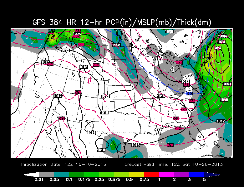
GFS forecast from WSI Energycast
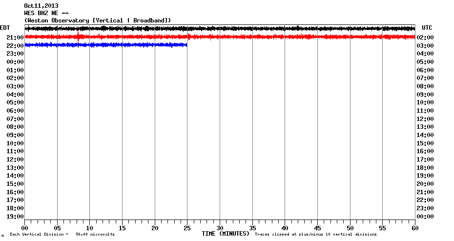
In other news...there was in earthquake in New Hampshire Thursday evening! Many folks around Franklin and Concord to Laconia felt it around 9:07pm. While the USGS site is essentially down thanks to the government shutdown, we're fortunate to have Boston College's Weston Observatory to be monitoring us! That's in cooperation with the New England Seismic Network. Below is a seismograph showing the tiny blip around 9:07p.
And here is the location. As of this writing, it was preliminarily listed as a M2.5, about 5km northwest of Contoocook, NH. Earthquakes are not rare to the Granite State, and this one caused no damage. Just a little evening excitement for anyone living nearby!

On the world weather front, a major disaster may be heading toward the east coast of India. Below is Phailin, a massive cyclone in the Bay of Bengal. It may become the most powerful hurricane that we've seen across the globe all season, and is expected to crash into India with winds gusting over 170mph. Needless to say, this will be a major concern and hopefully will not end in a humanitarian crisis. It's as large as Katrina, and essentially takes up the entire Bay of Bengal.
 Phailin Satellite Loop
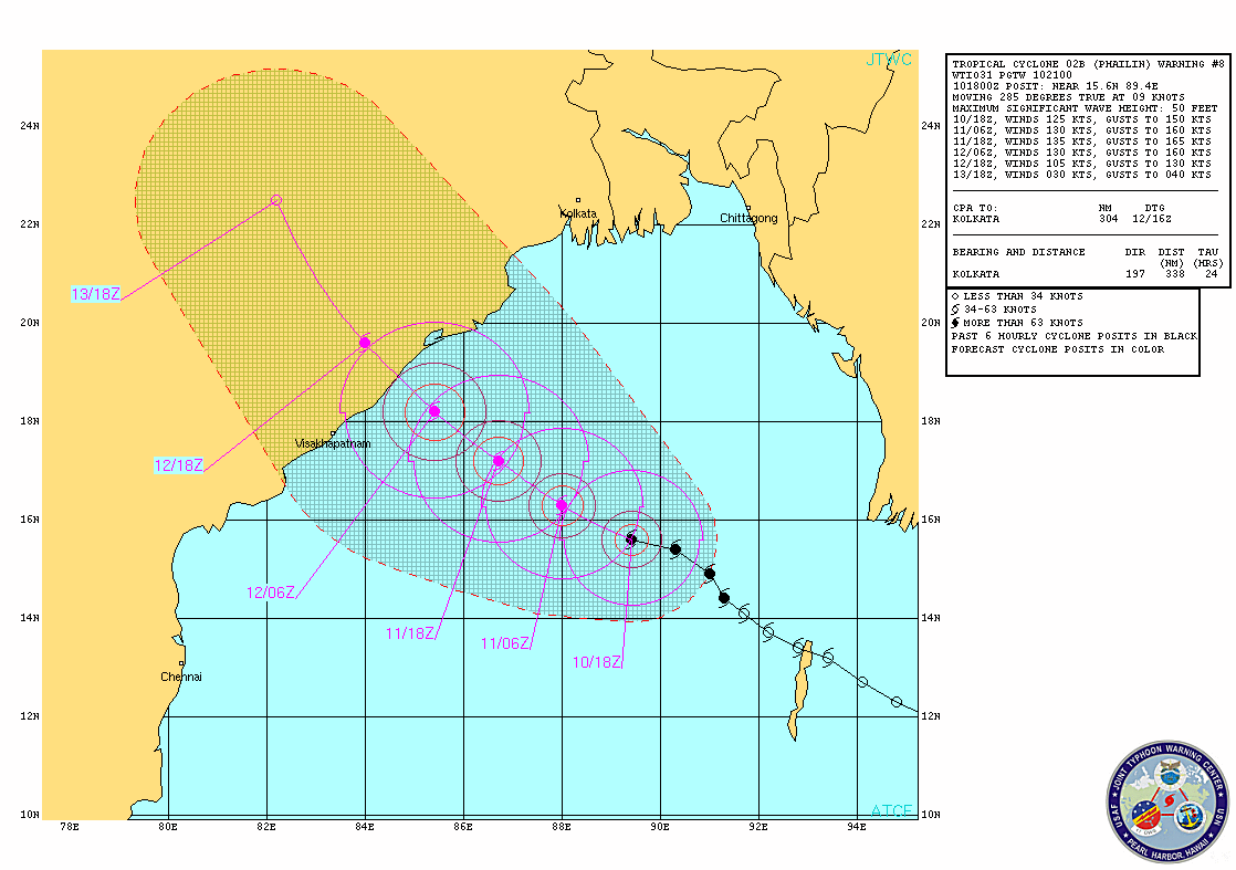
Phailin track and intensity forecast from the Joint Typhoon Warning Center