A 60 degree temperature swing ahead!
Hot enough to make things uncomfortable in rooms without AC, but not quite hot enough for record highs. Yes, it can certainly get hot in September in New England. In fact, temperatures in the 90s can (and have) occurred well into October. The daily record for September 11th remains at 99 degrees, and the all-time September record at Boston-Logan is a whopping 102 degrees. We officially hit 97 on Wednesday, with heat indices well into the triple digits. In any case, it was certainly hot enough for many.
Big storms are rumbling to our west tonight, and a few may survive as brief downpours into the Boston area. But most of eastern Mass will stay dry overnight as the forcing for these storms is much weaker in this part of the region. The highest chance of seeing one overnight will be across Worcester and northern Middlesex/Essex Counties. Take a peek at an HRRR forecast, showing a simulated radar. You can easily spot the trend of storms weakening to the east.
 HRRR Simulated Radar
For tomorrow, we'll still be in a sultry summer air mass. Our winds will shift slightly to nearly due south, and dew points will stay extremely high in the low 70s. We'll have a lot more cloud cover mixed in, due to the debris left over from previous storms Wednesday night. Those storms will spark anew as we head into the afternoon hours, but again they will start mainly to our west. The overall setup is more conducive to severe weather across the Hudson Valley and western New England, where a wind maxima will be rotating through. Shear will be higher there, and forcing stronger along the cold front.
So in these parts, we'll be watching the radar. With a more unidirectional flow from the south through levels of the atmosphere, the storms will not have a big push from the west to move them along. So they will slowly march eastward into the evening and overnight hours. The highest chances of rain for eastern and southeastern Mass will come after the sun goes down. A few storms could reach severe levels, but the main threats will be for gusty winds, lighting and heavy rain with plenty of water vapor to go around.
For the Patriots home opener, Nowcasting (forecasting on the fly during active weather) may be in effect. Either way you slice it, it will be hot and very humid, as well as quite breezy at 10-25mph. My gut tells me the rain will be just starting to push in around kickoff or shortly thereafter. I wouldn't go to the game without rain gear. Interestingly, the Patriots have only played 2 games in 80+ heat at Foxboro, and have won them both. So maybe the heat suits them!
A wave of low pressure forming along the front will keep rain in the forecast Thursday night and into Friday morning. Once it finally heads out to sea (and pushes Tropical Storm Gabrielle out to sea with it), the cold pool of air moving in aloft will promote more clouds and a few more afternoon showers. The wind will swing around to the north, bringing in much drier and cooler air. That's what we'll have for the weekend!
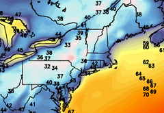
Saturday looks breezy and cool with highs in the 60s. With that cooler air aloft, some diurnal cumulus will pop up pretty quickly. The dense cloud cover will be across central and northern New England. The farther south you go, the clearer the skies will be. And for those of you who weren't big fans of the heat today...check out the GFS forecast lows for Sunday morning! That will be a good 60 degree swing for parts of the Northeast, from upper 90s to mid 30s.
Sunday looks WONDERFUL, a perfect fall day. Apple picking, hiking, grabbing a pumpkin or two, heading out to the Big E in West Springfield, whatever you want. Stunning with sunshine and highs near 70. Can't beat that! A quick front will bring a spot shower on Monday, and then we're back to the good stuff for Tuesday and Wednesday.
And for those who were watching the tropics...we technically *tied* the record for the latest the first hurricane of the Atlantic season has developed. Humberto became a hurricane at the 5am advisory, but Gustav is the overall latest to develop in 2002. It reached hurricane status on the same day, but 3 hours later! A close call for sure.


