Snow Tuesday Should Bring Delays, Cancellations, Challenging Commute
BOSTON (CBS) - All you have to do is step outside to know this is not your typical March weather. When you went out to start the car this morning, you were hit with temperatures which felt like January. Lows were in the teens and low 20's and some spots like Orange and Keene, New Hampshire got as low as the single digits!
Check: Interactive Radar | Current Conditions | Weather Blogs
This March is turning out to be almost as abnormal as last March, just in the other direction. March 2012 featured temperatures averaging more than 8 degrees above normal per day. One year later, Boston has already received 13.1 inches of snow this March and we are about to add significantly to that.
Read: Ask The Weather Team
Gas up the snowblower, put the plow back on the truck and grab the shovels from the shed, winter isn't done with us just yet, not even close.
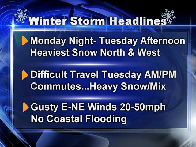
Snow will break out tonight between 10 p.m. and 1 a.m., first to the south and west (Worcester could see first flakes around 10 or 11) and last along the coast and to the north (in Boston by midnight or 1 a.m.).
Snow will fall steadily all night and this is key. In late March your best chance of getting good snow accumulation is for it to arrive at night. I believe the vast majority of the snow accumulation will occur overnight tonight and into Tuesday morning.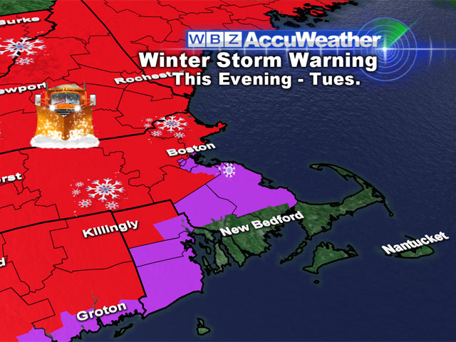
There will be a widespread 2-to-4 inches (at least) on the ground by Tuesday morning's commute, just about everywhere. I expect lots of delays, cancellations and an extremely challenging morning drive.
After 7 or 8 a.m., there will be a rain-snow line which will creep northward from the Cape. Also, the precipitation will begin to lessen in intensity by late morning. The combination of these two factors will likely halt or severely slow down the snow accumulation for a while.
Snow will change over to rain in all of southeastern Massachusetts during the morning and by midday it will likely be raining along the coast and in Boston as well.
Farther north and west, some light sleet and freezing rain will mix with the snow during this semi-lull period. Just when you think it may be ending, a second surge of energy will get drawn into the system and the precipitation will pick up once again.
By mid-to-late afternoon heavy rain and snow will once again be falling but this time temperatures will be a few degrees warmer. So round two will likely fall mainly as rain inside of Route 128, in Boston, and across all of southeastern Massachusetts.
The northern 495 belt (Lawrence-Lowell) will likely see a mix of rain, sleet and snow with round two. Farther north and west of 495, this will be another round of heavy, wet snow with several more inches of accumulation. The storm finally winds down after 8 p.m. (nearly 24 hours after it started), ending from south to north across Southern New England. It will actually continue well into the night in Central and Northern New England.
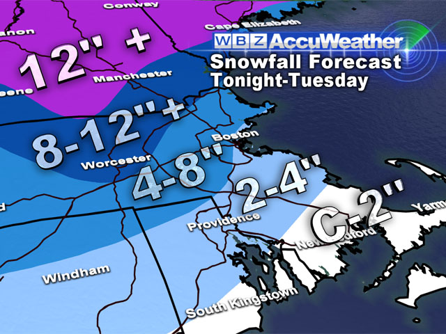
So how much?
A coating to 2" along the extreme South Coast and over Cape Cod, all at the very beginning of the event.
2-4" in Southeastern Massachusetts, away from the coast, again mainly in the first several hours of the storm, much of it washed away by rain on Tuesday.
4-8" From Boston and in the immediate suburbs, and down the Mass Pike.
8-12" around the northern belt of 495 and north and west into Northwest Middlesex County and Northern Worcester County and Southern New Hampshire.
12"+ in the hills of Southwest New Hampshire and all of Central and Northern New England. Another bonanza for ski resorts!
The good news, and I think we could all use some, is that this storm will not have a huge impact on the coastline. Tides are at their lowest levels for the month, so any coastal flooding will be minor during high tides around 5-6 a.m. and p.m.
Unfortunately we cannot escape some additional beach erosion, which will likely become the big and lasting story after this winter is said and done. Winds will be gusty along the coast, out of the east, 25-50mph during the storm, somewhat lower inland, this will not be a major concern for this storm but could cause some scattered power outages.
Normally the one thing you can just about lock up with March snow events is that it won't stick around very long. Typically the snow melt begins almost immediately and the strong March sun makes quick work of any exposed snow cover.
This time may be a little different. The days following this storm will stay fairly cold, certainly below normal with high temperatures mainly in the upper 30s the rest of this week with yet another chance of some snow coming on Thursday.
So if you are wondering if this was the last hurrah, the short answer is, I doubt it.
Spring may officially begin on Wednesday of this week, but I don't believe it will feel much like spring for at least another few weeks.
You can follow Terry on Twitter at @TerryWBZ.