Why Did We Get So Much More Snow Than Expected?
BOSTON (CBS) - Southern New England was hit with a storm to remember Friday as several towns that expected a few inches of snow ended up with close to two feet instead.
Check: Interactive Radar | Current Conditions | Weather Blogs
The intensity of the snow caught nearly everyone off guard, forcing schools to close at the last minute and plows to jockey for space with cars in rush hour traffic.
So why did we get so much more snow than expected?
Read: Ask The Weather Team
Let's start way back at the end of last week. You may remember at the time we were talking about a powerful storm that was going to blast the upper Midwest and the mid-Atlantic. From there it appeared that it was going to pass well to our south, about 600 miles in fact, harmlessly out to sea.
Check: Who Has The Most?
That is, in fact, what happened. The storm buried the country in snow from Montana to Maryland and emerged offshore around Virginia Beach, headed straight eastward, away from New England.
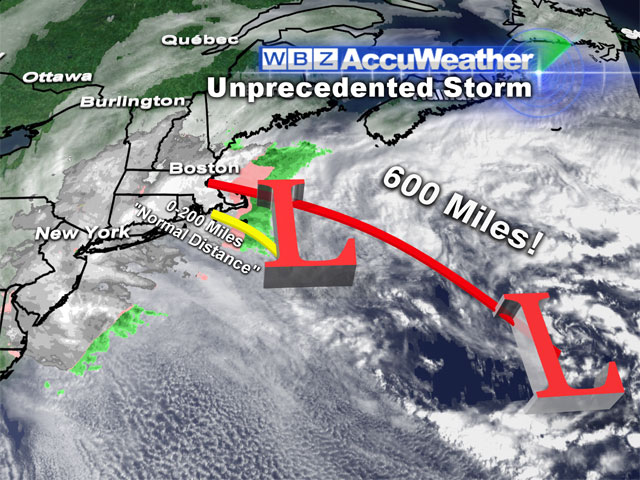
99 times out of 100 when a storm is that far south and heading east not north, it is of no concern to us in New England. The only exception to that may be in hurricane season just due to the sheer size and strength of some of the tropical systems.
This storm has been unlike anything we have ever seen or forecast.
In the words of meteorologist Barry Burbank, now in his 35th year forecasting weather here at WBZ-TV, "this has been an unprecedented event."
Here is what happened.
The storm exited the Virginia coast Wednesday morning and headed straight east, as expected.
However, a plume of moisture formed and blossomed and began to spread northward from the center of the storm. This band of moisture set up shop about 600 miles from the actual center of the storm, right over New England, and never moved or relented.
We actually caught onto this band on Wednesday and thought we had the forecast correct but a few key atmospheric factors changed the whole game.
1) Wind direction
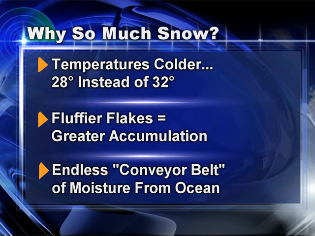
The winds were supposed to be east-northeast, a direction around 30 degrees. In actuality they were slightly more northerly, about 10 degrees. It doesn't sound like much, but this makes a huge difference.
2) Temperatures
Because of the slight shift in wind direction, the winds came mainly from the land, not the milder ocean and were about 2-to-4 degrees colder than expected.
3) Snow "ratio"
This 2-to-4 degree temperature difference turned what was supposed to be heavy, wet snow to a much fluffier snow. We were forecasting a 3-to-1 ratio, 3 inches of snow for every 1 inch of liquid precipitation, which would lead to about 4-to-8 inches of snow in the end.
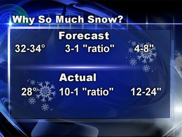
The colder temperatures raised that ratio to 10-to-1 and the 4-to-8 inches became 12-to-24 inches just like that.
And that is it.
A slight change in wind direction, leads to slightly colder temperatures, along with one monster of a storm with an abundance of precipitation all streaming right into southern New England and there's your recipe for Meteorological Disaster Soup. We all got an extra helping today.
I wish I could say that we won't get fooled again, but we all know that not to be true. We are in the business of predicting the future, the future of an endlessly moving and changing atmosphere.
We can look at endless computer models doing trillions of calculations and in the end we will never be able to forecast with anywhere near 100-percent accuracy.
Thereby lies the true pleasure and pain of being a meteorologist.
You can follow Terry on Twitter at @TerryWBZ.


