More Snow? A Wet And Stormy Pattern Forecast For Coming Weeks
BOSTON (CBS) - With the cleanup still ongoing from the Blizzard of 2013, the last thing anyone wants to hear is that dirty little four letter word coming out of the meteorologists this week (S-N-O-W).
Trust me I think I can speak for meteorologists all over New England, we don't need any more face-time on TV right now either.
Check: Closings | Interactive Radar | Forecast Maps | Current Conditions
Well, there appears to be some good news and some bad news today in our little corner of the world of weather. And since I know everyone could use some good weather news right about now I will start there.
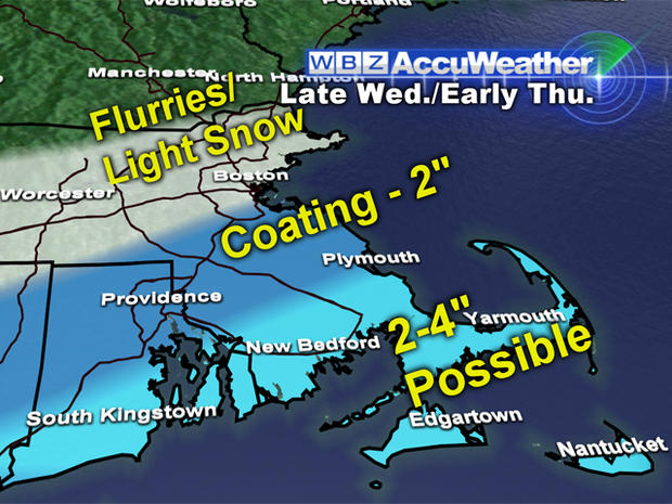
There are essentially two significant chances of snow this week and both of them appear as though they will be minor. The first chance comes late Wednesday night and early Thursday, this one never really looked like it would be all that impressive.
This storm has already formed and is currently bringing rain and snow to portions of Texas. It will actually give parts of the Mid-Atlantic some snow accumulation, places like Baltimore, Washington D.C., Philadelphia and even New York City could see a few inches.
But, when it arrives here Wednesday night around midnight, the majority of the snow will be just a bit too far south, over the Atlantic Ocean. We will catch the northern fringe and for about 6-8 hours early Thursday morning some light snow is likely across southeastern Massachusetts. Best chance of accumulation will be over Cape Cod and the Islands as well as extreme southeastern Mass. 2-to-4 inches are possible down there.
From Boston and the Mass Pike south to about Plymouth, a dusting to an inch or two is possible. Farther north, just a few flurries or a period of light snow but no accumulation is expected north and west of the city.
Storm number 2 has put a bit of a scare into us this week, but thankfully appears now as though it will not develop into a major storm for the Northeast.
Weather models had been having a tough time over the last few days painting a clear picture of how events would unfold this weekend, with some suggesting that another significant winter storm would develop.
That worst case scenario now appears unlikely, all the pieces are not going to line up this time, at least not in time for New England to get another blow.
There may be some light snow on Saturday (a few inches at most), but the real storm development looks like it will happen out to sea, another snowstorm for the fishes.
So you remember I said there was good news AND bad news?
Well I think there is a very good chance that we haven't seen our last big snowstorm this season.
Don't get me wrong, I am not forecasting or expecting a Blizzard of 2013 Part 2. But, the weather pattern is changing to some degree and the Southern Jet Stream is becoming very active.
This means there is a much higher potential for big, "juicy" East Coast storms to develop, whether they hit New England or not, or come in the form of rain or snow, is yet to be determined.
However, for at least the next couple of weeks, a wet and stormy pattern seems likely across the eastern U.S.
So keep the shovels handy and the snowblowers gassed up, winter likely has a few punches left.