Weekend Storm Evolves Into Less Snow, More Ice
BOSTON (CBS) - Ice, ice baby … this storm is evolving quickly, even as I type. The snow threat is lowering as the ice and flooding rain threat is rising. There are all kinds of hazards to pour through with this event, so let's get right to it.
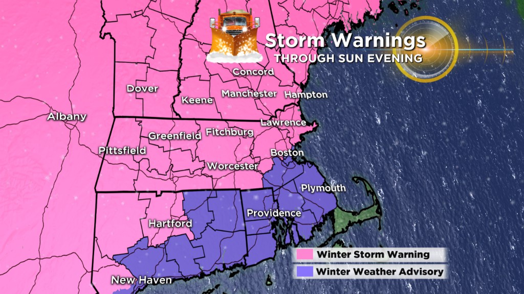
QUICK TIMELINE
Snow starts: Between 8 p.m. and 10 p.m. (the steady stuff).
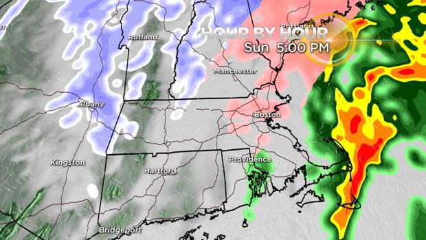
Change to rain/ice:
2 a.m. – South Coast, Cape
4 a.m. – Boston, Worcester
6 a.m. – 495, nearing MA/NH border
Rain/ice tapers: Between 2 p.m. and 5 p.m. Sunday afternoon.
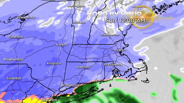
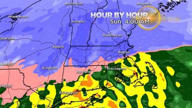
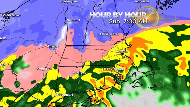
SNOW
Expect light flurries in the air here and there through 8 p.m. Saturday, but the steady, accumulating stuff holds off until after 8 p.m. There is a small window for snowfall with this storm, and if you blink, you might miss it. By the time most folks wake up Sunday morning, it will be rain, sleet or freezing rain.
AMOUNTS
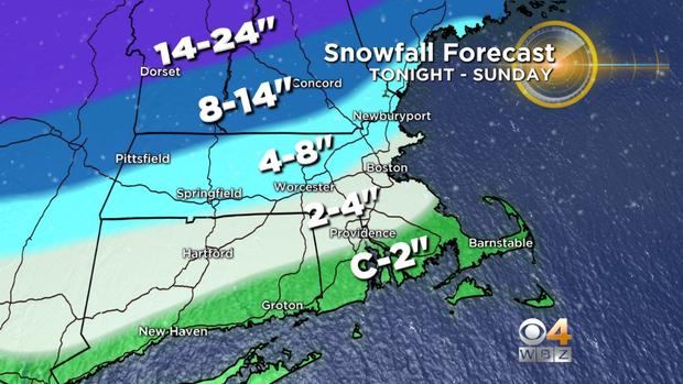
C-2" – Southern Plymouth County and Bristol County, Cape and Islands … all quickly washed away.
2"-4" – Providence to Boston, northern Plymouth and Bristol counties, Norfolk County, southern Essex County … again mostly washed away or severely compacted.
4"-8" – 495 (northwest of Boston) from Marlboro to Lowell and Lawrence and all areas farther northwest in southern New Hampshire … severely compacted by change to ice Sunday.
8"-14" – or higher. Generally in the higher elevations of central and northern New England.
ICE
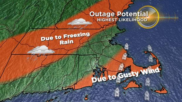
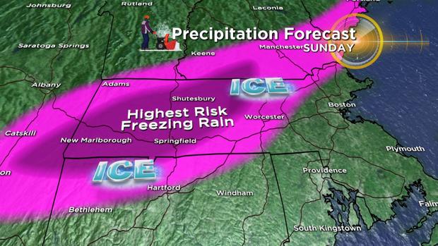
This is our biggest concern with this storm. A large amount of sleet and freezing rain will fall for a good portion of the day on Sunday. All areas north and west of Boston, especially those north and west of 495, are in the crossfire for a large amount of sleet and freezing rain. Sleet is not all that concerning, but freezing rain can be extremely hazardous. Freezing rain is essentially rain that falls and freezes as it makes contact with the ground level. The primary area of concern for freezing rain accretion is an area from Hartford, Conn., to Springfield, Mass., to northern Worcester County and parts of northern Middlesex County and into southern New Hampshire and coastal Maine. There is a risk of .10"-.25" or more of ice accretion in this area on Sunday. This will add a lot of weight to tree limbs and lines and increase the risk for power outages as the wind picks up behind the storm.
RAIN
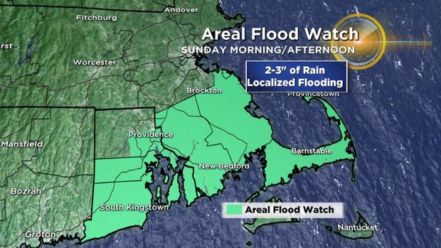
This storm is absolutely loaded with moisture. Parts of our area could receive nearly 3" of liquid, nearly unheard of for a winter storm. Those areas at greatest risk for inland flooding would be southeastern Massachusetts and Cape Cod. Torrents of rain and downpours on Sunday morning and afternoon will lead to areas of localized street and urban flooding. I certainly wouldn't be surprised if there were some embedded thunderstorms in southeastern Massachusetts on Sunday.
COASTAL FLOODING
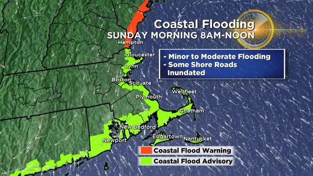
With the track of the storm now coming farther north, likely close to Boston, the coastal flood threat has lessened for a good portion of the area. The South Shore and Cape Cod will have winds out of the south-southwest, an offshore direction for many of the typical flood prone areas. South-facing beaches on the Cape and Islands may experience some minor to moderate flooding.
Along the North Shore and particularly along the New Hampshire and Maine coastline, there remains a concern for minor to moderate coastal flooding. The winds in these areas will generally be out of the east-northeast on Sunday morning, a more typical direction for a winter time flooding event.
The only high tide of concern is on Sunday morning, peaking between 8 a.m. and noon. After this time frame, winds will be offshore (west-northwest) behind the storm system.
WIND
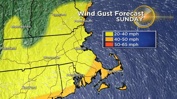
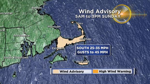
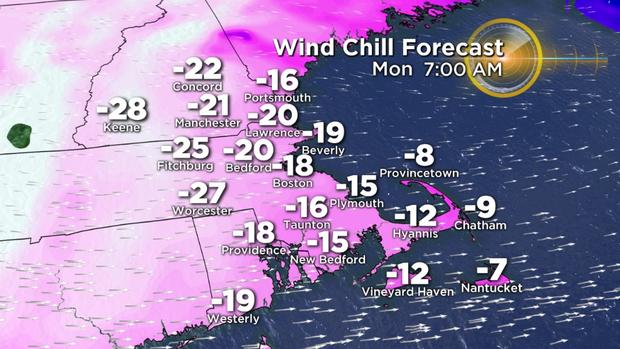
While winds won't be real strong with this event, they will be just gusty enough to increase the risk of power outages. Two areas of greatest concern – Cape Cod and the Islands – will experience the strongest gusts (40-50 mph) on Sunday morning/afternoon out of the south. Later in the day, as the storm pulls away and colder air rushes in, the entire region will gust between 20-40 mph, right through the night on Sunday. Wind chill values will plunge as low as -20 to -30 degrees late Sunday night and during Monday morning.
FLASH FREEZE/BITTER COLD
The coldest air of the season will pour in here directly from northern Canada Sunday afternoon and night. The entire region will plunge well below freezing, making a glacier of all the precipitation that fell earlier. By Monday morning, most suburbs will be in the single digits or below zero. High temperatures on Monday will struggle to reach 10 degrees. Then, another frigid night Monday night, with many towns going back below zero and only a modest rise in to the low 20s by Tuesday afternoon.
This is clearly a complex storm system and is still changing by the minute. Please stay with WBZ-TV and CBSBoston.com for updates … and stay safe!
Follow Terry on Twitter @TerryWBZ.