Direct Hit Or Glancing Blow? Monday Nor'easter's Track Taking Shape
BOSTON (CBS) – Don't shoot the messenger. Another nor'easter may be on the way for early next week. How much more can we take?
This relentless pattern producing blow after blow to New England just seemingly won't end. Three nor'easters in less than two weeks? Our Coastline is listing, our trees are falling, our nerves are on edge. It seems we've never needed a weather respite more than we do right now.
The only comparison that comes to mind would be the snow blitz back in February 2015. But this is March and we are oh so close to flowers blooming, burgers on the grill and reading a book on the beach. so close yet so far.
Before you smash your computer screen, there is hope for more of a glancing blow this time. Models over the last 24-48 hours are latching on to a track that would be significantly farther east than our last two nor'easters. Under this scenario, we would still get some rain, snow and wind but not nearly the impact that a closer track would produce.
WATCH: Barry Burbank and Eric Fisher on next storm
But alas, it is still early. As of this writing we are a solid 72 hours away from the storm's arrival and a A LOT can happen and change in that timeframe. So here you go. Don't let what you are about to read ruin your weekend, just stash this information in the back of your brain, "to be dealt with later".
Let's break this down into three possible scenarios.
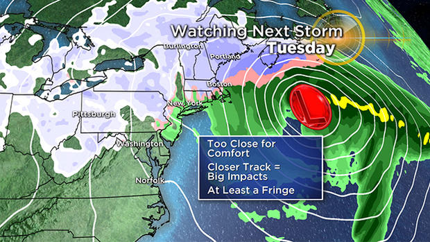
Timeframe for a storm would be late Monday, Monday night and Tuesday.
Scenario #1
This is the free and easy one - a complete miss. Unfortunately, this is also the least likely scenario.
Odds of this scenario: 10 percent. "So you're tellin' me there's a chance."
Scenario #2
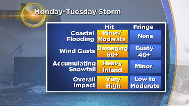
A hit. This would mean the storm goes right over (or very close to) the 40N 70W mark, the benchmark for most of our biggest and most productive storm tracks here in New England. This would be a full-fledged raging nor'easter. This worst-case scenario would bring another foot-plus of snow to parts of the area and wind gusts over 60 mph, centered along the coast. It could bring another round of power outages, tree damage and general misery. Any good news? Well, the tides are low astronomically, so coastal flooding would likely be minor to moderate at worst. Also temperatures would be a bit colder than the last storm, meaning a lighter-type of snow, not nearly as heavy and wet. That would be where the good news would end.
Odds of this scenario: 30 percent
Scenario #3
A fringe or glancing blow. The track would be outside the 40N 70W area, farther east. So, the heaviest precipitation and strong winds would all be offshore over the fishes. Impacts in Southern New England would be like that of a mini-nor'easter. Some light to moderate snow amounts, likely 6 inches or less. Gusty winds, but likely 40 mph or less and very little, if any coastal flooding.
Odds of this scenario: 60 percent
And there you have it… place your bets!
Obviously, we will be updating the forecast all weekend long on WBZ-TV and CBSBoston.com.
Follow Terry on Twitter @TerryWBZ