Not Out Of The Woods Yet: Precipitation Over, But Wind And Waves Still A Concern
BOSTON (CBS) – We're not out of the woods just yet. While the precipitation may be done, there is still a good deal of wind, waves and flooding to deal with this weekend.
RAIN
Again, the rain is done, but many towns received between 4-6 inches in parts of southeastern Massachusetts.
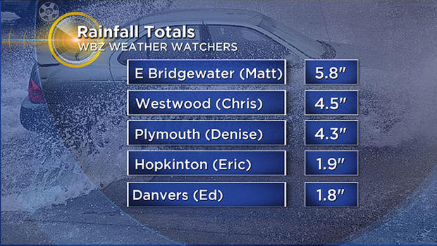
Take a look at some of these final totals from our WBZ Weather Watchers:
Matt in East Bridgewater – 5.8 inches
Chris in Westwood – 4.5 inches
Denise in Plymouth – 4.3 inches
The rest of the area from Boston and points north generally received between 1-3 inches.
SNOW
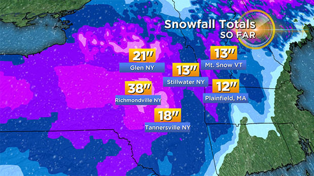
We knew this would be the toughest part of the storm to predict. The atmosphere was right at the tipping level last night but thankfully remained just mild enough for mainly rain instead of a very heavy, wet snow.
Just imagine if temperatures had been a few degrees colder - this would have easily been one of our greatest snowstorms ever recorded. Instead, most of the snow fell in the Berkshires and New York state.
Totals out that way got as high as 1-4 feet!
We did get some minor accumulations locally:
Franklin – 2.1 inches
Worcester – 1.2 inches
Lexington – 0.2 inches
WIND
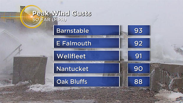
The wind gusts last evening were some of the strongest we have seen in more than a decade! We haven't seen such widespread and persistent wind gusts 80-90+ since perhaps the storm back on December of 2005 or more likely all the way back to Hurricane Bob in 1991.
The winds decreased significantly overnight, but will remain gusty (especially along the Coast, Cape and Islands).
Gusts 45-65 mph will persist for a good portion of today over extreme southeastern Mass.
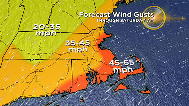
Farther inland, expect gusts between 35-45 mph.
Cut those numbers in half for Sunday - still gusty but no longer damaging.
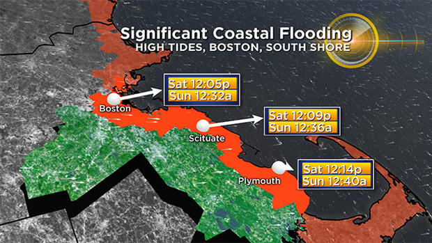
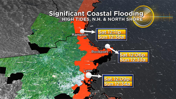
COASTAL FLOODING
The last big concern with this storm remains the widespread coastal flooding. Thankfully, last night's high tides came in just a bit shy of forecast. While there was still significant flooding, it could have been much worse.
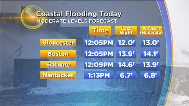
Our next high tide arrives around noon Saturday and forecasts are for another round of moderate flooding, in fact a bit higher than last night in most areas.
With the winds turning to a more northerly direction (and also decreasing) all subsequent high tide cycles should gradually lower.
The next high tide, after midnight tonight, will bring mainly minor flooding.
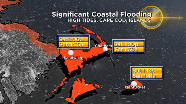
There may be some pockets of moderate flooding along the north side of Cape Cod Bay.
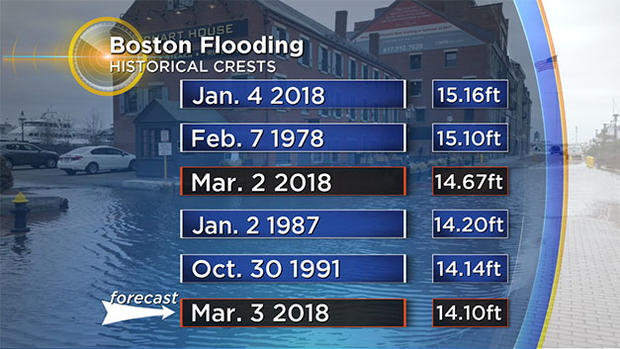
As a side note, the tide levels around Noon on Friday reached the third highest ever recorded in Boston, coming up just shy of the Blizzard of '78 and our January nor'easter of this year.
WHAT'S NEXT
A little light snow in the air later on Sunday and Sunday night, could leave a coating to an inch in spots. A quiet start to the work week, with temperatures around average for early March (low 40s).
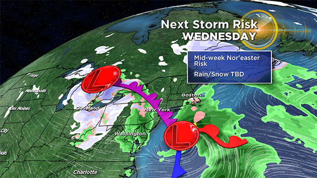
The big talk this week will revolve around another potential coastal storm in the Wednesday/Thursday timeframe.
While it is too early to tell exactly what impact this storm may have here, there is certainly a chance of another round of significant rain/snow and wind (although nothing like what we just experienced).
Follow Terry on Twitter @TerryWBZ