Nor'easter Slams Southern New England - Here's What's Still To Come
BOSTON (CBS) - An historic nor'easter is delivering a crushing blow to southern New England.
CHECK: Widespread Power Outages
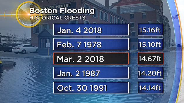
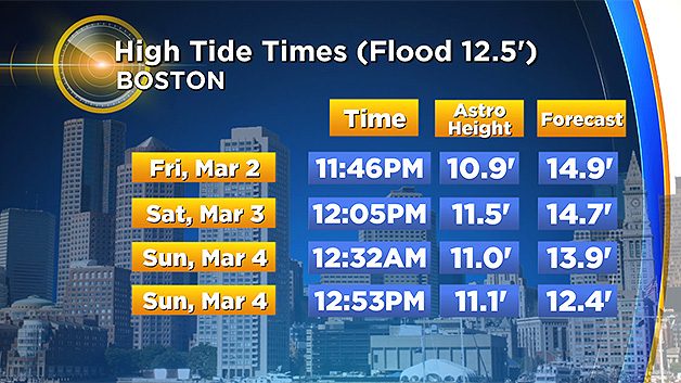
Our first high tide of concern reached near record levels midday Friday. Boston crested at 14.67 feet, the third highest level ever recorded, behind only the Blizzard of '78 and the January 4th storm.
And the storm has really just begun.
Here is a brief look at where we stand and what is still to come:
RAIN
As of noon Friday most areas already had 1-to-2 inches of rain. Bands of heavy rain will continue to rotate in from the ocean all afternoon long, before eventually changing to wet snow. Final rainfall totals will range between 2-to-4 inches, with a few higher amounts likely.
Widespread urban and small stream flooding is certain with some main stem (larger) rivers rising to near their banks.
SNOW
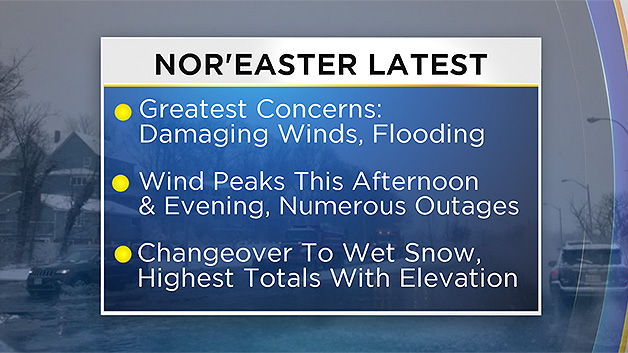
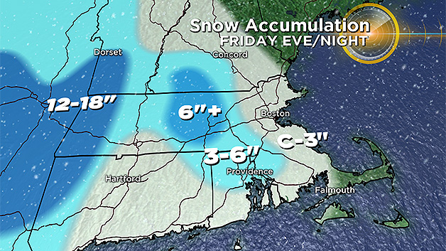
Our entire region is teetering on the brink of changing from rain to snow. The thermal profiles are very borderline. The Berkshires have been snowing heavily all day and will end up with 12-to-20 inches+ of snow accumulation.
There are two other areas of concern with regards to snow accumulation:
Worcester Hills:
It's likely to change from rain to wet snow early to mid-afternoon, with several inches (perhaps 6 or more) accumulating by tonight.
Rhode Island and SE Mass:
As the storm starts to pull away this evening, colder air will rotate southward. There will still be a heavy band of precipitation over southeastern Mass. as this occurs. So, we anticipate rain changing to snow in this region after 7 p.m. with the possibility of a few to several inches of accumulation before tapering off by midnight.
The rest of the area including Boston and Middlesex and Essex counties will likely see a change to snow later this afternoon. However there likely will not be enough precipitation left in this area for any significant snow accumulation.
WIND
Winds gusted 30-60 mph all morning on Friday with the peak winds expected between 1 and 8 p.m.
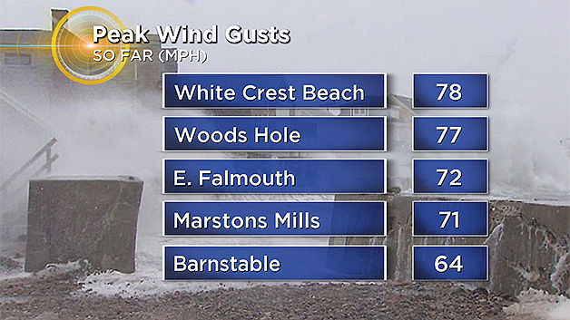
Expect frequent gusts of 40-60 mph across eastern Mass. and 60-80 mph along the coastline, Cape and Islands.
Trees and telephone poles will continue to fall all afternoon and evening. Expect severe damage to vulnerable homes along the coastline and power outages to continue to grow exponentially hour by hour.
While winds will slowly decrease later tonight, they will remain gusty all weekend long. Gusts to 50 mph+ are expected at the coast on Saturday and 20-40 mph on Sunday.
COASTAL FLOODING
Having already exceeded tide levels from the Perfect Storm in 1991 and nearly reaching the Blizzard of '78 and the January nor'easter, it is clear this storm is not to be underestimated.
This is a very dangerous, life-threatening event along our coastline, particularly at ocean exposed shorelines from Salisbury to Plymouth.
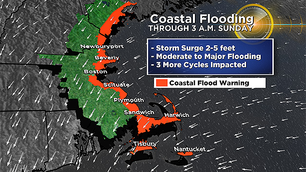
The next high tide of concern arrives around midnight tonight, and levels are predicted to be even higher than midday Friday, likely reaching levels just shy of all-time record highs.
Tonight's high tide will feature the peak and worst flooding from this storm for most east-facing locations.
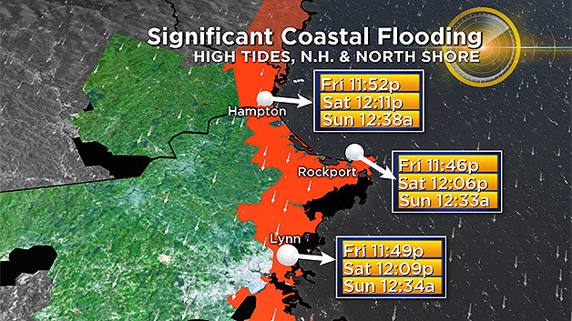
The next high tide cycle arrives around noon on Saturday. Moderate flooding is anticipated for most coastal locations with this occurrence.
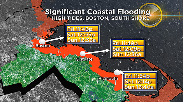
However, the north facing shoreline of Cape Cod Bay will likely receive major flooding given the change in wind direction to a more northerly component.
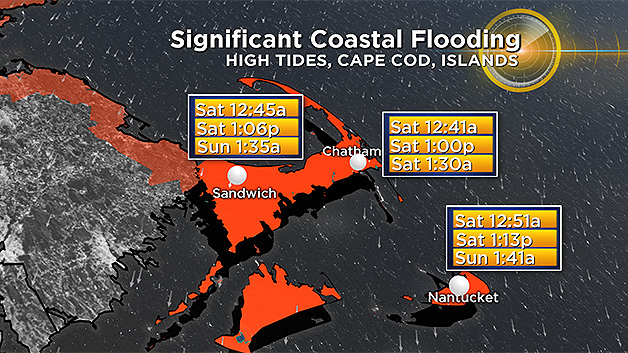
Saturday night's high tide just after midnight will likely only have minor to pockets of moderate flooding (again most pronounced in Cape Cod Bay).
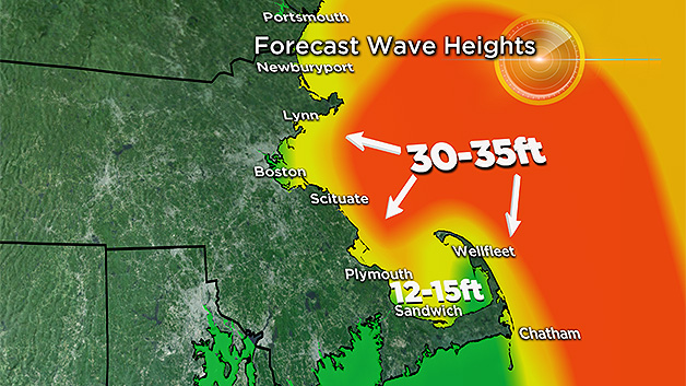
The wave action from this storm will be absolutely incredible. Wave heights just offshore will grow to 30-40 feet!
Significant beach erosion is another major concern given the strength and duration of this event. Many protective dunes and sea walls will be challenged and some homes may be permanently damaged or perhaps washed into the ocean.
Please heed all warnings and stay tuned to updated forecasts throughout the event on WBZ-TV and CBSBoston.com.
Follow Terry on Twitter @TerryWBZ


