Major Coastal Storm Likely To Impact Southern New England Friday-Saturday
BOSTON (CBS) - I am trying so hard not to use the classic "in like a lion" phrase to describe the storm that is on the way…It just fits it so perfectly. After a "walk in the park" month of February (I mean people were literally walking in the parks it was so mild), you just had to know that March wasn't gonna follow suit. And sure enough, right on cue, as we flip the calendar, a major Coastal storm is about to take shape.
Our atmosphere is going through all sorts of changes right now. Large-scale, major pattern shifts are occurring as we speak and these will have dramatic effects on the weather in New England and across the Country in the coming days and weeks. The Arctic Oscillation (many times coupled with talk of the dreaded Polar Vortex) is weakening, sending pockets of cold, Arctic air plunging southward to the continents of Europe and North America. At the same time, another common measure for a stormy pattern in New England, the North Atlantic Oscillation (NAO) is tanking…this essentially means high pressure is about to stack up over Greenland, pushing cold and stormy conditions southward into the northeastern United States.
So what does all this mean? Basically, don't count out winter just yet. While we are still a good 24 hours away from being able to give a more confident, detailed forecast for Friday-Saturday, it is becoming more and more clear that Southern New England will see significant impacts from this developing monster of a storm.
The next few days are quiet…Wednesday will bring the warmest temperatures of the week thus far, nearing 60 in many areas. Clouds will be increasing Thursday but still a fairly quiet, pleasant day.
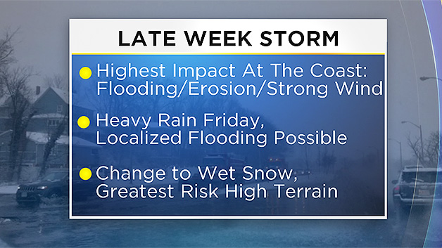
The focus for this upcoming storm will be Friday into Saturday.
PRECIPITATION
This remains the biggest wildcard right know. While odds favor more rain than snow, until we lock in a storm track there will continue to be some questions as to precipitation type and amounts.
Best chance for significant snowfall appears to be well to our west…through southern portions of New York State, northern Pennsylvania and perhaps into western Connecticut. A bit closer to home, there may be some lighter snow totals in parts of the Berkshires, Vermont and perhaps as far north as the White Mountains of New Hampshire. Snow is less certain in these areas due to the possibility of some mixing with rain.
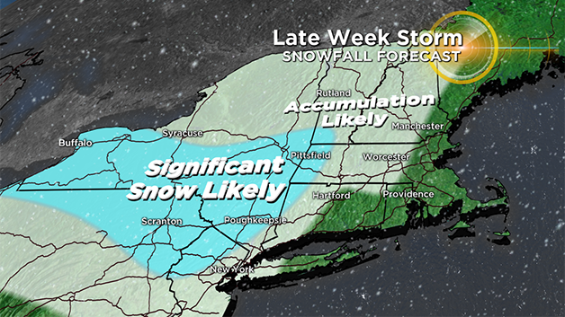
For the rest of Massachusetts and Southern New Hampshire it looks a bit too warm for much snow accumulation. Odds favor mainly rain here, with perhaps some wet snow mixing in later in the storm.
WINDS
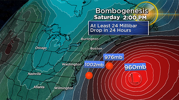
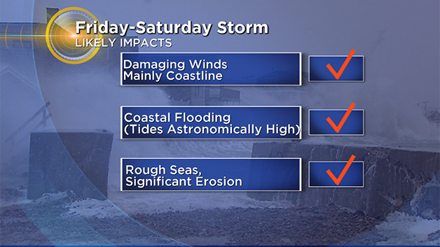
Confidence is much higher with regards to wind with this storm. This may be another case of "bombogenesis" as the storm will undergo rapid deepening while transferring its energy to the Mid-Atlantic Coastline. This storm will become an absolute monster south and east of Nantucket later Friday and Saturday. This will create a large and powerful wind field, extending out several hundred miles from the storm's center.
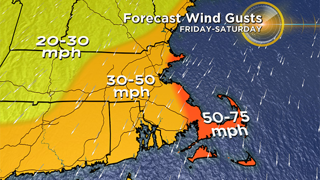
Cape Cod and the Islands are at greatest risk for damaging winds, perhaps ranging as high as 50-75mph Friday and Saturday.
The rest of Eastern MA will see winds gusting 30-50mph, enough to cause some scattered damage and perhaps some power outages.
COASTAL FLOODING
Unfortunately this storm is coinciding with astronomically high tides. In fact, the highest tide levels of the month will occur smack dab in the middle of this storm on Friday and Saturday. Combine that with a persistent and prolonged east – northeast wind over several high tide cycles and you have the recipe for some serious coastal issues.
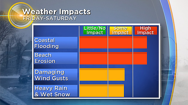
A coastal flood watch has been issued by the National Weather Service, in effect from Friday morning through Saturday afternoon for the entire eastern Mass. coastline from Nantucket to the New Hampshire border. A storm surge of 2-to-3 feet is forecast. Widespread moderate coastal flooding is likely meaning some structural damage will be possible, road closures will occur and some evacuations of isolated neighborhoods may be necessary.
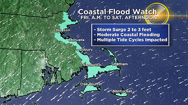
Three high tide cycles will be impacted: Friday morning's high tide (around 11 a.m.), Friday night's high tide (around midnight) and again Saturday (around midday).
The seas will be rough for several days during and following the storm (it is a slow mover) 15-25 foot seas are likely just offshore through at least Sunday.
Significant beach erosion is another major concern given the strength and duration of this event.
As this storm is still some 2-3 days away, I would urge that you stay tuned for updates on WBZ-TV and CBSBoston.com.
Any small change in track with a storm this size and scope will cause dramatic forecast changes.