What Happened? Poor Modeling, Fluff Factor Led To Forecast Error
BOSTON (CBS) - So that was a bit of a surprise! Were you one of those lucky folks to get 7-8" of snowfall this morning? No, you didn't miss a forecast update, this one was clearly under-forecast in some areas south of Boston. In fact, you may have noticed a slight lowering of forecast snow totals yesterday (we went from 2-5" down to 2-4" for the 5pm newscast on WBZ). Behind the scenes, we actually discussed lowering the forecast even farther (glad we didn't).
The storm just didn't have that look yesterday…it was ragged, seemingly progressive (moving more east, out to sea, than northeast), and to boot, the air was exceedingly dry over southern New England. It had all the ingredients of an underachiever (just the opposite of what it turned out to be). Not only did it look lame on satellite and radar, but our model guidance yesterday was coming in lighter and lighter. One model of note was just about pitching a shutout (no snow accum.) for us a few hours before the arrival of storm. Don't get me wrong, I am not going to blame a bad forecast on a computer model, BUT these models have gotten REALLY good in the last few years. Many of the hi-res models are now able to pick up on very small features, like localized banding, something we could never dream of years ago. Nothing we saw yesterday indicated the potential for up to 8" of snow…
So what happened?
Well a couple things...
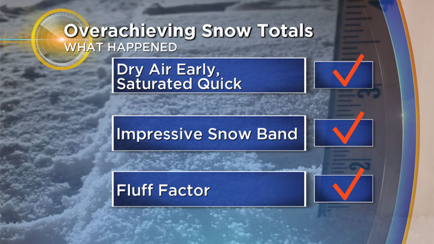
1) Poor modeling…Again, the computer models never really got a good grip on this one. There was significant waffling between a non-event to a light to moderate snowfall for the last several days. And very few indications of a bigger snowfall, if anything we feared the opposite.
2) Banding…A classic monkey wrench and forecast-buster, the nearly stationary, heavy band of snow. It is a fairly common occurrence in nor'easter-type events and something we have been able to forecast much better recently due to computer model enhancements…not this time. Frequently in coastal storms you will notice one or two areas of brighter blue or white on the radar, in a line or band, some distance to the north and west of the storm's center. Again, this is common and happens where the greatest lift is happening in the atmosphere. This didn't seem like the type of storm to produce one of these heavy snow bands, at least not over land. Well, guess what, it happened. For several hours this morning, a band of moderate to heavy snow sat right over southeastern MA and stretched back into Rhode Island and parts of eastern Connecticut and Long Island. This is where snowfall amounts were nearly double what was forecast.
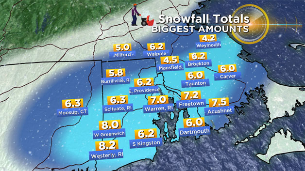
3) The Fluff Factor…Adding insult to injury, the dreaded fluff factor. In a typical snowstorm, the ratio of water to snow is 10:1…meaning you get about 10" of snow for every 1" of liquid. In colder storms, that ratio is a bit higher and we thought that may be the case, perhaps as high as 15:1. Welp, try more like 20 or 25:1! Just .2-.4" of liquid equated to 5-8" of snowfall in the jackpot zone.
Some of you may be reading this thinking I am crazy…the forecast was actually pretty darn good in many areas, take for instance the Pike from Boston to Worcester. Boston was forecast to get up to 2" and ended up with 2.4"
Same deal in Worcester, we though a coating to 2" and they got 1"
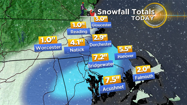
North of the Pike also went well. Folks from Fitchburg to Westford to Andover woke up to nothing, and probably are shaking their heads right now saying, what storm?
But we are better than that now, or at least we think we are. The definition of a good vs bad forecast has changed in recent years. Ten or 20 years ago a busted forecast was a real BUST…meaning a complete miss one way or another. Our technology and understanding of the weather has greatly improved since those days, making a complete bust very unlikely (but not impossible). Instead, a bad forecast now means getting 4-8" when the forecast was 2-4". Was it a bad forecast? Yes. But a complete bust? Well, that depends on your perspective and certainly your location!
We pride ourselves on the ability to give you the most accurate and timely forecast possible. As much as technology continues to improve, the atmosphere is a crazy place and remains, to some degree, unpredictable. So while the complete and utter forecast failures may become less and less frequent, there will still be, inevitably, some forecast error.
Will we ever see the day when forecasts are perfect? I highly doubt it. But rest assured we are doing everything in our power to get as close as we can get.