Winter Weather Forecast - January 2018 Update
BOSTON (CBS) - It's only fitting during the 40th anniversary of a monster February blizzard that we talk about what's in store for this February and March.
We thought now would be a good time to look at our winter outlook from November, see how it's doing, and look forward to the home stretch. We are past the climatological midway points for both coldest average temperature (January 18th) and average snowfall (January 27th) in the Boston area. Every day is bringing more daylight and a stronger sun. Spring is starting to ping in the back of our minds, but alas we know winter is far from done.
Last year, we went to the beach in February and set records in New England for warmest temperatures so early in the season.
There was even a tornado (the only one of the year in Massachusetts) that touched down in Conway! Of course three years ago, in 2015, it was an epic snow blitz that buried New England and set records for cold. You can get a little bit of everything in the longest-shortest month of the year. And it *always* snows at least once.
Let's start with how things are going so far. Back in November, here were the takeaways we outlined for the upcoming season:
- The winter would be front loaded with December having the biggest cold departure from average
- Ice storms would be in play (a hallmark of La Nina winters)
- We would see more clippers than in previous years
- Milder than average temperatures would fight back mid-January into February
- We called for about 40″ of snow in Boston this winter (+/- 5″), around 75″ in the snow belt zones of central and northern Mass, 15-30″ Cape Cod and the South Coast, and a big year across northern New England.
I think we can say that so far, things are going pretty well!
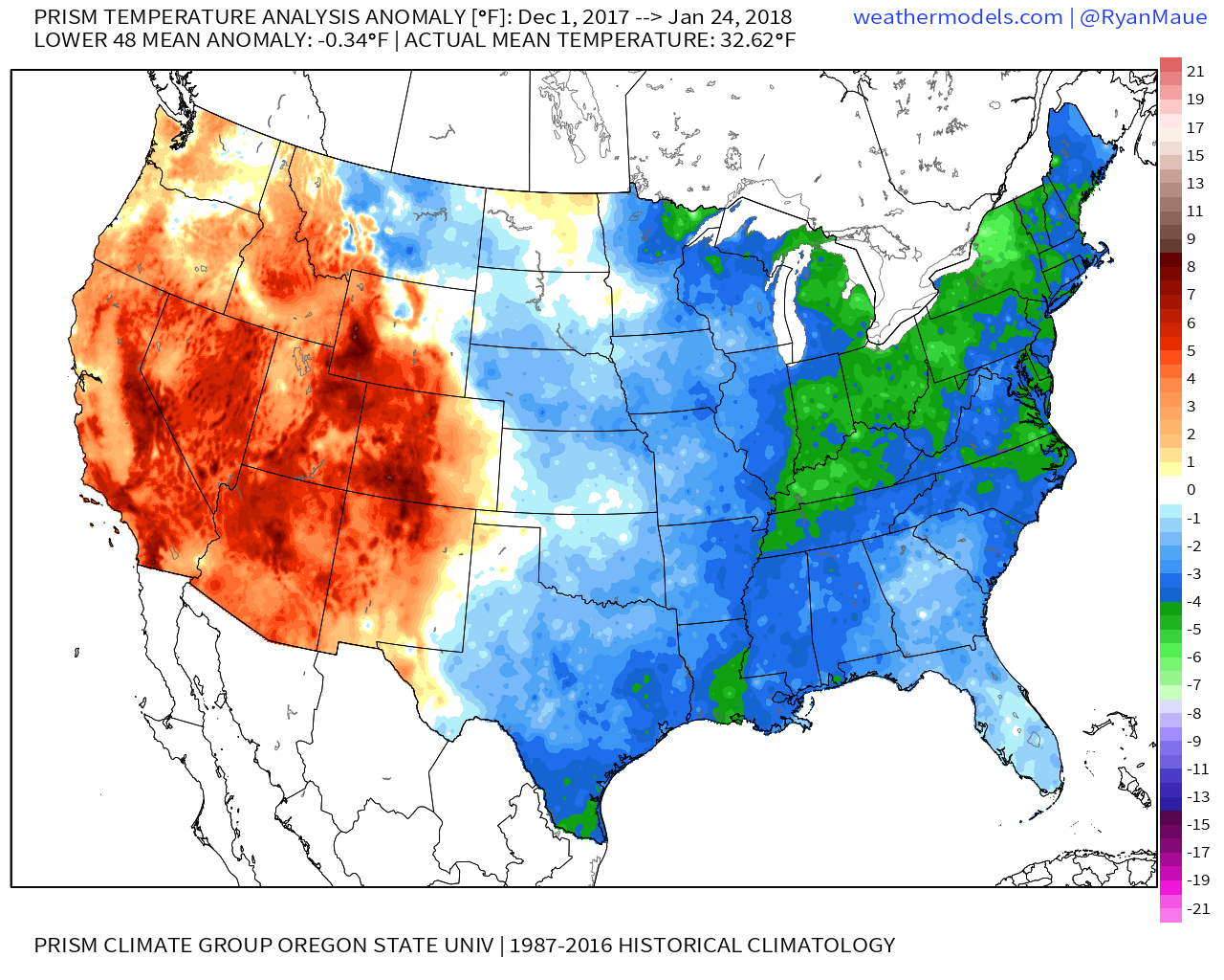
December finished -4.0F versus average, largely because of an absolutely frigid blast starting after Christmas. Slurpee waves returned to Nantucket and ice chunks washed ashore on Cape Cod. While early January cold was superlative and was in fact the coldest first week of January on record for most of New England, we are going to end up finishing right about average for the month as a whole. Several bursts of mild air with insider-runner storms helped bring the whole month back to neutral. So we are on track for December having the coldest departure from average.
We had a major ice storm right before Christmas, and have had a couple of different ice events outside of that one potent storm. We've definitely had a number of clippers swing down across the region with lots of northern stream energy in this La Nina background state. And milder than average temperatures have started to fight back lately. I'd say generally the 'January thaw' has been decent but has not quite lived up to pre-winter expectations.
How about snowfall?
It's been a bullish start but we've stepped off the gas a bit the last couple of weeks. We are sitting at an exactly average amount of snow for the season as of this writing for most of southern New England. So February (maybe March too?) will be our make or break month. We need about 20-40" more across SNE to reach average for the entire season (ranging from the Boston area to central Massachusetts).

Without further ado, let's get to what's on deck for the rest of the season.
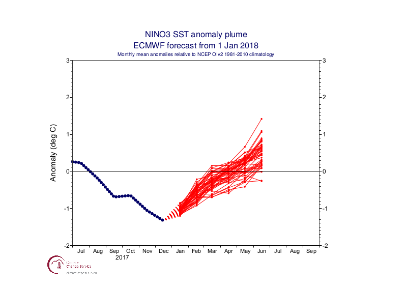
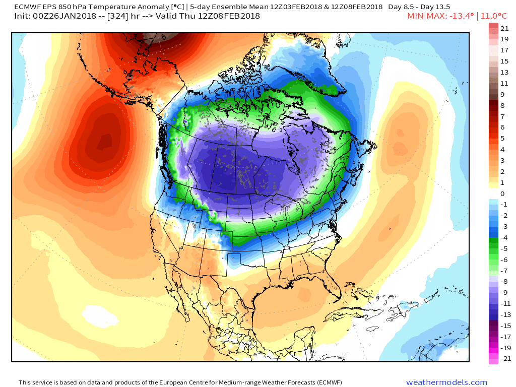
While February looks to start out generally mild with another inside-tracking storm, signs are pointing toward a burst of more very cold air mid to late month which could linger into March. We've been monitoring a reservoir of frigid arctic air that's been cooking over Siberia recently. At some point, it's only natural that this is going to flush out and head elsewhere in the hemisphere. The major high-latitude blocking that produced times of record-setting cold across the eastern U.S. earlier in the season has retrograded west, thanks to a warm rotation of the MJO (Madden-Julian Oscillation). This tropical forcing has shifted the pattern to bring stormier and colder conditions to the western U.S. after a very warm and dry first half of winter. So things have recently been in a state of 'evening out.'
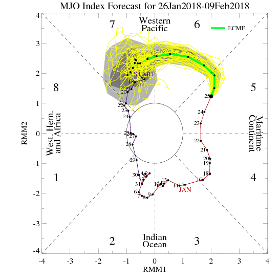
The MJO is expected to continue its rotation into the colder phases (8,1,2) soon. And with that, we may see our ridge-trough positions switch back to what we saw in early January. This could help transport some of that very cold Siberian air over to our side of the world and bring snowstorm potential back to New England as well. The cold starts to plunge across the Upper Midwest and Plains first (starting to happen right now) and then should begin to shift east later in the month.
Most of the longer-range guidance is hitting mid-February into mid-March as the most likely time for us to get quite cold again. If it truly ends up being as anomalously cold as the first arctic blast we received, then our outlook for a warmer than average winter overall won't pan out. We'll have seen a colder than average December-January combo and if February can't hold on to milder than average conditions there's no way to make up the deficit. As of this writing, it looks unlikely that February will be much above average for temperatures (if at all). If it is indeed colder than average, it will be the fourth straight colder than average month in Boston. A streak like that hasn't happened for three years, and has occurred only twice so far this decade (both during winters, interestingly enough).
Naturally, colder conditions help to favor snowfall. February is peak East Coast storm season, and we have a pretty interesting setup waiting in the wings.
It appears there will be a decent amount of western Atlantic ridging pushing back against very cold arctic air descending from Canada. That's pretty prime for an active storm track from the Midwest to the Northeast and Mid-Atlantic. Whether we get snow, rain, or mix always comes down to just a few miles of difference in track. But overall I'd say it looks like we have plenty more opportunities for some snow to visit over the next month and a half. Certainly not time to put away the snowblowers!
We probably won't kick off spring too early here in New England.
La Nina has likely just peaked but is expected to linger into spring and perhaps even summer before completely loosening its grip. This could help to keep us chilly early in spring with perhaps some relaxation in that cold pattern during the second half of March into April. So it may end up being another March in the trenches after all. As we always state with the seasonal outlooks, it's a budding science and far from perfect. We'll hope the tea leaves are wrong and we'll bask in some warm March days! At the very least, we know 7 o'clock sunsets start in March and the equinox is on the 20th. In the long run, the sun wins. Look for St. Patrick's Day to be the hinge point.